Ferwerderadiel
Ferwerderadiel
Ferwerderadeel | |
|---|---|
Municipality | |
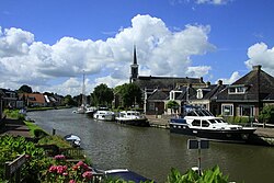 Canal through Burdaard | |
 Flag  Coat of arms | |
 Location in Friesland | |
| Coordinates: 53°20′N 5°50′E / 53.333°N 5.833°ECoordinates: 53°20′N 5°50′E / 53.333°N 5.833°E | |
| Country | Netherlands |
| Province | Friesland |
| Merged | 2019 |
| Area | |
| • Total | 133.18 km2 (51.42 sq mi) |
| • Land | 97.71 km2 (37.73 sq mi) |
| • Water | 35.47 km2 (13.70 sq mi) |
| Elevation | 1 m (3 ft) |
| Time zone | UTC+1 (CET) |
| • Summer (DST) | UTC+2 (CEST) |
| Postcode | 9070–9179 |
| Area code | 0518, 0519, 058 |
| Website | www |

Ferwerderadiel (![]() pronunciation) is a former municipality of Friesland in the northern Netherlands. Its official name is West Frisian, the Dutch name is Ferwerderadeel (pronounced [fɛrˈʋɛrdəraːˌdeːl] (
pronunciation) is a former municipality of Friesland in the northern Netherlands. Its official name is West Frisian, the Dutch name is Ferwerderadeel (pronounced [fɛrˈʋɛrdəraːˌdeːl] (![]() listen)). In 2019 it merged with the municipalities of Dongeradeel and Kollumerland en Nieuwkruisland to form the new municipality Noardeast-Fryslân.
listen)). In 2019 it merged with the municipalities of Dongeradeel and Kollumerland en Nieuwkruisland to form the new municipality Noardeast-Fryslân.
Population centres[]
Bartlehiem, Blije, Burdaard, Ferwert, Ginnum, Hallum, Hegebeintum, Jannum, Jislum, Lichtaard, Marrum, Reitsum, Wânswert, Westernijtsjerk.
Topography[]

'Dutch topographic map of the municipality of Ferwerderadiel, June 2015
Notable people[]

St. Fredk. van Hallum
- Saint Frederick of Hallum (ca. 1113 – 1175) a Premonstratensian priest
- Barthold Douma van Burmania (1695 in Hallum – 1766) a Dutch statesman and ambassador to the court of Vienna
- Pieter Boeles (1795 in Ferwerd – 1875) a Dutch Minister and linguist
- Gerardus Heymans (1857 in Ferwert – 1930) a Dutch philosopher, psychologist and academic
- Watse Cuperus (1891 in Blije – 1966) a Dutch journalist and writer in the West Frisian language
- Eeltsje Boates Folkertsma (1893 in Ferwert – 1968) a West Frisian language writer
- Maria Sterk (born 1979 in Hallum) a Dutch marathon speed skater
Gallery[]

Birdaard, drawbridge and church
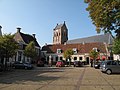
Ferwerd, Vrijhof and church

Marrum, church
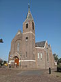
Hallum, church


References[]
- ^ "Kerncijfers wijken en buurten 2020" [Key figures for neighbourhoods 2020]. StatLine (in Dutch). CBS. 24 July 2020. Retrieved 19 September 2020.
- ^ "Postcodetool for 9172PJ". Actueel Hoogtebestand Nederland (in Dutch). Het Waterschapshuis. Archived from the original on 21 September 2013. Retrieved 8 September 2013.
- ^ "Bevolkingsontwikkeling; regio per maand" [Population growth; regions per month]. CBS Statline (in Dutch). CBS. 1 January 2019. Retrieved 1 January 2019.
External links[]
 Media related to Ferwerderadiel at Wikimedia Commons
- Official website
| show Places adjacent to Ferwerderadiel |
|---|
| show Authority control |
|---|
This Friesland location article is a stub. You can help Wikipedia by . |
Categories:
- Noardeast-Fryslân
- Former municipalities of Friesland
- Friesland geography stubs