Arancón
Arancón | |
|---|---|
 Asunción church | |
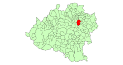 | |
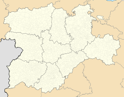 Arancón Location in Spain. | |
| Coordinates: Coordinates: 41°48′2″N 2°16′53″W / 41.80056°N 2.28139°W | |
| Country | |
| Autonomous community | |
| Province | |
| Comarca | |
| Judicial district | |
| Municipality | Arancón |
| Government | |
| • Alcalde | Gregorio García Martín (2007) (PP) |
| Area | |
| • Total | 77.61 km2 (29.97 sq mi) |
| Elevation | 1,065 m (3,494 ft) |
| Population (2018)[1] | |
| • Total | 85 |
| • Density | 1.1/km2 (2.8/sq mi) |
| Time zone | UTC+1 (CET) |
| • Summer (DST) | UTC+2 (CEST) |
| Postal code | 42180 |
| Dialing code | 975 |
| Website | Official website |


Arancón is a municipality in the province of Soria, Spain, located at the foot of the mountain range of and Mount Cencejo. The localities that form it are Arancón, , , , and .
Main sights[]
- Roman road: Via 27 of Antonino, which united Caesaraugusta (Zaragoza) with Asturica Augusta" (Astorga).
- Medieval source of La rana ("The Frog")
- Two Roman milliarium are exposed in a public garden next to the Church. They were used during the Middle Ages to lay the foundations of a bridge. Arancón can be considered the milliarium capital in Soria. After the church there are another two milliarium.
- Asunción romanesque church (Arancón)
- Concepción church ()
- Saint Bartholomew hermitage ruins
Economy[]
This section does not cite any sources. (April 2021) |
- Culture of wheat, rye, barley and sunflower
- Sheep cattle and pasture rent
- Greater hunting boundary
Flora and fauna[]
Flora includes holm-oak, rivets, steppe, tea, camomile, heather and lavender
Wildlife include wild boar, red deer, roe deer, rabbit, hare and partridge
References[]
- ^ Municipal Register of Spain 2018. National Statistics Institute.
| Wikimedia Commons has media related to Arancón. |
This article about a location in the province of Soria, Spain is a stub. You can help Wikipedia by . |
Categories:
- Municipalities in the Province of Soria
- Province of Soria geography stubs