Herrera de Soria
Herrera de Soria | |
|---|---|
 | |
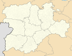 Herrera de Soria Location in Spain. | |
| Coordinates: 41°45′46″N 3°00′44″W / 41.76278°N 3.01222°WCoordinates: 41°45′46″N 3°00′44″W / 41.76278°N 3.01222°W | |
| Country | |
| Autonomous community | |
| Province | |
| Municipality | Herrera de Soria |
| Area | |
| • Total | 26.07 km2 (10.07 sq mi) |
| Elevation | 1,094 m (3,589 ft) |
| Population (2018)[1] | |
| • Total | 9 |
| • Density | 0.35/km2 (0.89/sq mi) |
| Time zone | UTC+1 (CET) |
| • Summer (DST) | UTC+2 (CEST) |
| Website | Official website |


Herrera de Soria is a municipality located in the province of Soria, Castile and León, Spain. According to the 2004 census (INE), the municipality had a population of 21 inhabitants.
References[]
- ^ Municipal Register of Spain 2018. National Statistics Institute.
This article about a location in the province of Soria, Spain is a stub. You can help Wikipedia by . |
Categories:
- Municipalities in the Province of Soria
- Province of Soria geography stubs