Caracena
Cueva de Ágreda | |
|---|---|
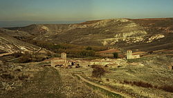 Panoramic view of Caracena | |
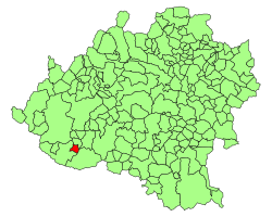 Location of Caracena in Soria Province | |
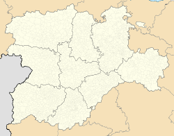 Cueva de Ágreda Location in Spain. | |
| Coordinates: Coordinates: 41°22′59″N 3°5′28″W / 41.38306°N 3.09111°W | |
| Country | |
| Autonomous community | |
| Province | |
| Municipality | Caracena |
| Area | |
| • Total | 18.15 km2 (7.01 sq mi) |
| Elevation | 1,080 m (3,540 ft) |
| Population (2018)[1] | |
| • Total | 15 |
| • Density | 0.83/km2 (2.1/sq mi) |
| Time zone | UTC+1 (CET) |
| • Summer (DST) | UTC+2 (CEST) |
| Website | Official website |

Caracena is a municipality located in the province of Soria, in the autonomous community of Castile and León, Spain.
There is a Romanesque church, St Peter's. From the point of view of the Catholic Church, it is part of the Diocese of Osma, which in turn is part of the Archdiocese of Burgos.
This village is located in , a historical road from Alicante to Burgos. Caracena is located between and Carrascosa de Abajo.
Situation[]
Located on the banks of the Caracena river, limits with:
- From the south with , and .
- From the west with and .
- From the north with Carrascosa de Abajo.
- From the east with , and the deserted town of Pozuelo.
The road access takes place by the local road who connects with . This road have connection with Spanish provinces of Soria and Segovia due to the connection between the local road and the that starts in Ayllón.
References[]
- ^ Municipal Register of Spain 2018. National Statistics Institute.
Authority control | |
|---|---|
| General | |
| National libraries | |
This article about a location in the province of Soria, Spain is a stub. You can help Wikipedia by . |
- Municipalities in the Province of Soria
- Province of Soria geography stubs