Argelia, Antioquia
This article needs additional citations for verification. (January 2013) |
Argelia | |
|---|---|
Municipality | |
 | |
 Flag  Seal | |
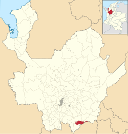
 Location of the municipality of Argelia in the Antioquia Department | |
 Argelia Location in Colombia | |
| Coordinates: 5°44′33″N 75°8′47″W / 5.74250°N 75.14639°WCoordinates: 5°44′33″N 75°8′47″W / 5.74250°N 75.14639°W | |
| Country | |
| Region | Andean Region |
| Department | |
| Subregion | Eastern |
| Area | |
| • Total | 254 km2 (98 sq mi) |
| Population (2005) | |
| • Total | 8,911 |
| • Density | 35/km2 (91/sq mi) |
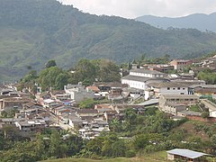
Argelia is a town and municipality in Antioquia Department, Colombia. Part of the subregion of Eastern Antioquia.
Climate[]
Argelia has a tropical rainforest climate (Af) which closely borders a subtropical highland climate. It has very heavy rainfall year round.
| Month | Jan | Feb | Mar | Apr | May | Jun | Jul | Aug | Sep | Oct | Nov | Dec | Year |
|---|---|---|---|---|---|---|---|---|---|---|---|---|---|
| Average high °C (°F) | 22.8 (73.0) |
23.3 (73.9) |
23.6 (74.5) |
22.8 (73.0) |
22.9 (73.2) |
23.2 (73.8) |
23.5 (74.3) |
23.3 (73.9) |
23.1 (73.6) |
22.2 (72.0) |
22.1 (71.8) |
22.2 (72.0) |
22.9 (73.2) |
| Daily mean °C (°F) | 18.3 (64.9) |
18.7 (65.7) |
19.1 (66.4) |
18.9 (66.0) |
18.7 (65.7) |
18.7 (65.7) |
18.8 (65.8) |
18.7 (65.7) |
18.5 (65.3) |
18.0 (64.4) |
18.0 (64.4) |
18.1 (64.6) |
18.5 (65.4) |
| Average low °C (°F) | 13.9 (57.0) |
14.2 (57.6) |
14.6 (58.3) |
14.6 (58.3) |
14.9 (58.8) |
14.6 (58.3) |
14.1 (57.4) |
14.1 (57.4) |
13.9 (57.0) |
13.9 (57.0) |
14.0 (57.2) |
14.0 (57.2) |
14.2 (57.6) |
| Average rainfall mm (inches) | 365.9 (14.41) |
400.0 (15.75) |
512.6 (20.18) |
484.8 (19.09) |
477.7 (18.81) |
330.0 (12.99) |
332.5 (13.09) |
324.1 (12.76) |
461.4 (18.17) |
555.4 (21.87) |
564.9 (22.24) |
494.4 (19.46) |
5,303.7 (208.82) |
| Average rainy days | 24 | 22 | 27 | 26 | 25 | 21 | 19 | 19 | 24 | 27 | 27 | 27 | 288 |
| Source 1: [1] | |||||||||||||
| Source 2: [2] | |||||||||||||
See also[]
References[]
Categories:
- Municipalities of Antioquia Department
- Antioquia Department geography stubs
