Guatapé
Guatapé | |
|---|---|
Municipality and town | |
 Aerial image of Guatapé and in the background the Piedra del Peñol | |
 Flag  Seal | |
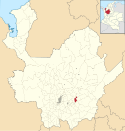 Location of the municipality and town of Guatapé in the Antioquia Department of Colombia | |
| Country | |
| Department | |
| Subregion | Eastern |
| Elevation | 1,890 m (6,200 ft) |
| Demonym(s) | Guatapenses Guatapeños |
| Time zone | UTC-5 (Colombia Standard Time) |
Guatapé is a town and municipality in the Department of Antioquia, Colombia.[1] It is a part of the subregion of Eastern Antioquia and is located 79 kilometres (49 mi) from Medellín, the capital of the department. Guatapé is bordered on the north by Alejandría, San Rafael to the east, and Granada and El Peñol to the south. This town is the gathering place for Las Vegas, referring to the small farms of the area.
The town is a major tourist attraction, especially for travelers from Medellín. El Peñón de Guatapé, a large rock that visitors can climb, and the famous zócalos (murals) that adorn several buildings attract many tourists.
History[]
Before Iberian conquistadors reached the area in the 16th century, this territory was inhabited by indigenous groups, some controlled by a cacique named Guatape. In his honor, the town was named after him. The name "Guatapé", comes from the Quechua language, related to "stones and water". Another name that the town had in the past was "La Ceja de Guatapé".
In 1714, the indigenous people under Guatapé of this region were grouped into a shelter known as "San Antonio de Remolinos Peñol". Traces of their existence come from clay urns found in the town of Alto Verde, and several archaeological sites not yet studied in the villages of La Peña, La Piedra, El Roble and El Rosario.
Guatapé was founded 4 October 1811, by the Spaniard Don Francisco Giraldo y Jimenez. It was declared a municipality in September 1867.
Guatapé has undergone changes throughout its history. It was predominately a farming town that relied on livestock, agriculture and mining. Empresas Públicas de Medellín built a large hydroelectric complex here in the 1970s. This megaproject produced large impacts on social, economic, political, environmental and cultural development in the locality. With the construction of this dam, Guatapé became one of the most important electric production centers in the country.
Demographics[]
Total Population: 6,469 inhabitants (2015)
- Urban population: 5,045
- Rural population: 1,424
Literacy: 92.3% (2005)
Ethnicity: According to figures presented by DANE census in 2005, the ethnic makeup of the township is the following:
- Mestizo & White (99.96%)
- Afro-Colombian (0.04 %)
Sites of interest[]

- Calle del Recuerdo ("Memory Lane")
- Parish Church of Nuestra Señora del Carmen
- Chapel of Our Lady of Santa Ana
- Community Historical Museum.
- Pueblo de Zócalos
- Waterfalls
La Piedra[]

El Peñón de Guatapé is a rock formation that borders a lake. It formed along the Antioquia Rock Base (batolito de antioquia), 70 million years ago. With two-thirds of its height below ground, the exposed vertical face is over 200 meters high and visible from throughout the surrounding countryside. Visitors can scale the rock via a staircase built into one side, a path that includes more than 649 steps to the top.[2] On the flat top of the rock, food vendors offer outdoor tables overlooking vistas that stretch to the horizon in every direction. Above the food vendors are two gift shops, and an open-air viewing area to see the spectacular scenery.
Also you can visit two monasteries, that belong to the "Benedictinos" Communities. The monks are devoted to receive and share with visitors.
There are many Ferries available, to take tours around the dam, and to visit islands known as "The Fantasy Island Hotel", located at 3 NM, north of Guatapé shore. There are also many extreme and traditional water sports available.
As of April 2009, there were plans to construct an airport for ultralight aviation.[3]
Zócalos[]
Each building has tiles along the facade's lower walls in bright colors and dimensioned images. Many of the tiles are tied to the products sold by the shops, or the beliefs of the residents. Others are cultural images of the farming heritage of the community.
Gallery[]
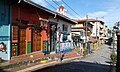
Typical street scene in Guatapé
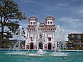
Church of Our Lady of Carmen

Map of neighborhoods and veredas


References[]
- ^ "Alcaldía de Guatapé - Antioquia". Government of Antioquia State (in Spanish). Archived from the original on 2015-12-03. Retrieved 2010-03-24.
- ^ Guatape's Official Major Office. Retrieved 2009-04-03.
- ^ "Guatape Official Site". Government of Antioquia State. 2009-04-03. Retrieved 2009-04-03.[dead link]
External links[]
| Wikimedia Commons has media related to Guatapé. |
 Guatape travel guide from Wikivoyage
- Corporacion CIMTED, Desarrollo desde lo local, Entrepreneur projects in the Guatape City
- ON-LINE RADIO STATION - LIVE GUATAPE VIDEO
| hide | |||||||||||||||||||
|---|---|---|---|---|---|---|---|---|---|---|---|---|---|---|---|---|---|---|---|
Capital: Medellín | |||||||||||||||||||
| Regions and municipalities |
| ||||||||||||||||||
| Related topics | |||||||||||||||||||

- Municipalities of Antioquia Department
- Populated places established in 1811