Aringay
This article needs additional citations for verification. (August 2013) |
Aringay | |
|---|---|
| Municipality of Aringay | |
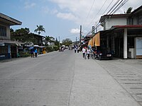
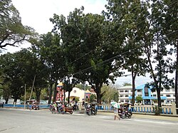 Aringay town center along the National Highway | |
 Flag  Seal | |
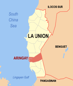 Map of La Union with Aringay highlighted | |
show OpenStreetMap | |
 Aringay Location within the Philippines | |
| Coordinates: 16°23′54″N 120°21′20″E / 16.398208°N 120.355481°ECoordinates: 16°23′54″N 120°21′20″E / 16.398208°N 120.355481°E | |
| Country | Philippines |
| Region | Ilocos Region |
| Province | La Union |
| District | 2nd district |
| Founded | 1641 |
| Barangays | 24 (see Barangays) |
| Government | |
| • Type | Sangguniang Bayan |
| • Mayor | Eric O. Sibuma |
| • Vice Mayor | Benjamin O. Sibuma |
| • Representative | Sandra Y. Eriguel |
| • Municipal Council | show
Members |
| • Electorate | 30,606 voters (2019) |
| Area | |
| • Total | 84.54 km2 (32.64 sq mi) |
| Elevation | 38 m (125 ft) |
| Highest elevation | 299 m (981 ft) |
| Lowest elevation | 0 m (0 ft) |
| Population (2020 census) [3] | |
| • Total | 50,380 |
| • Density | 600/km2 (1,500/sq mi) |
| • Households | 10,621 |
| Economy | |
| • Income class | 2nd municipal income class |
| • Poverty incidence | 8.59% (2015)[4] |
| • Revenue | |
| • Assets | |
| • Expenditure | |
| Service provider | |
| • Electricity | La Union Electric Cooperative (LUELCO) |
| Time zone | UTC+8 (PST) |
| ZIP code | 2503 |
| PSGC | |
| IDD : area code | +63 (0)72 |
| Climate type | tropical monsoon climate |
| Native languages | Ilocano Pangasinan Tagalog |
| Website | www |


Aringay , officially the Municipality of Aringay (Ilocano: Ili ti Aringay; Filipino: Bayan ng Aringay), is a second class municipality in the province of La Union, Philippines. According to the 2020 census, it has a population of 50,380 people. [3]
Known in Philippine History as the birthplace of revolutionary leader Diego Silang,[5] its economy is based primarily on agriculture, producing rice, tobacco and fruit crops as economic staples. A nascent tourism industry is centered on its beach resorts. Its ethnic population is predominantly Ilocano and Christian (Roman Catholic).
Geography[]
Aringay is located about 239 kilometres (149 mi) north of Manila and 31 kilometres (19 mi) south of San Fernando, the regional and provincial capital.
Climate[]
The town experiences the prevailing monsoon climate of Northern Luzon, characterized by a dry season from November to April and a wet season from May to October.
| hideClimate data for Aringay, La Union | |||||||||||||
|---|---|---|---|---|---|---|---|---|---|---|---|---|---|
| Month | Jan | Feb | Mar | Apr | May | Jun | Jul | Aug | Sep | Oct | Nov | Dec | Year |
| Average high °C (°F) | 30 (86) |
31 (88) |
33 (91) |
34 (93) |
33 (91) |
31 (88) |
30 (86) |
29 (84) |
30 (86) |
31 (88) |
31 (88) |
31 (88) |
31 (88) |
| Average low °C (°F) | 20 (68) |
21 (70) |
22 (72) |
24 (75) |
25 (77) |
25 (77) |
25 (77) |
25 (77) |
24 (75) |
23 (73) |
22 (72) |
21 (70) |
23 (74) |
| Average precipitation mm (inches) | 15 (0.6) |
16 (0.6) |
24 (0.9) |
33 (1.3) |
102 (4.0) |
121 (4.8) |
177 (7.0) |
165 (6.5) |
144 (5.7) |
170 (6.7) |
56 (2.2) |
23 (0.9) |
1,046 (41.2) |
| Average rainy days | 6.3 | 6.6 | 9.5 | 12.8 | 20.6 | 23.5 | 25.4 | 23.4 | 23.2 | 21.4 | 14.0 | 8.2 | 194.9 |
| Source: Meteoblue [6] | |||||||||||||
Barangays[]
| Rank | Barangay | Population | Rank | Barangay | Population | |
|---|---|---|---|---|---|---|
| 1 | San Eugenio | 3,682 | 14 | Macabato | 1,235 | |
| 2 | Poblacion | 3,464 | 15 | San Simon West | 1,225 | |
| 3 | San Benito Sur | 3,354 | 16 | Pangao-aoan East | 1,221 | |
| 4 | Dulao | 3,284 | 17 | San Juan West | 1,182 | |
| 5 | Santa Rita West | 3,192 | 18 | Santa Rita East | 1,078 | |
| 6 | Santa Lucia | 2,861 | 19 | San Simon East | 1,051 | |
| 7 | Samara | 2,487 | 20 | San Antonio | 1,024 | |
| 8 | San Benito Norte | 2,428 | 21 | Gallano | 1,014 | |
| 9 | Basca | 2,050 | 22 | San Juan East | 899 | |
| 10 | Santa Cecilia | 1,823 | 23 | Alaska | 891 | |
| 11 | Santo Rosario West | 1,789 | 24 | Pangao-aoan West | 807 | |
| 12 | Manga | 1,465 | Aringay Total | 44,949 | ||
| 13 | Santo Rosario East | 1,443 | ||||
History[]

Aringay was an ancient village known in pre-colonial times as Alingay or Alinguey. When Spanish colonizers arrived in the late 16th century, they found an enclave of ethnic Pangasinenses actively trading with their Ilocano and Ifugao neighbors and traders from China, Japan and Southeast Asia. In a small village now known as Samara, a settlement headed by a descendant of Lakan Dula is thriving. The presence of Spanish soldiers, administrators, and Augustinian missionaries ushered in the town's colonial era and its conversion to Roman Catholicism.
Aringay remained a part of Pangasinan province until April 18, 1854, when the Spanish fused the northern towns of that province with the southern towns of Ilocos Sur to create the new province of La Union (hence, "The Union") The municipalities of Caba and Gallano (later placed in the province of Benguet and then abolished in 1900) were later carved out of Aringay's northern borders.
The 18th and 19th centuries marked the active expansion of Ilocano territory. Scores of migrants from the Ilocos provinces pushed their way south so that by the end of the 19th century, Aringay was home to mostly Ilocano and Ilocanized Pangasinenses.
Outbreaks of rebellion rocked the town during four centuries of Spanish, American and Japanese colonization. Bloody confrontations ignited by revolutionaries such as Diego Silang and Gabriela Silang during Spanish occupation and by insurgents during the Philippine–American War and the Japanese occupation in World War II marred the bucolic villages of Aringay.
A decisive battle on Aringay River against U.S. forces crippled US forces. By 1901, the province of La Union was freed by the American occupation.
Japanese forces attacked Aringay in December 1941 and occupied the town until their brutal withdrawal in 1945–1946, when many Aringayenos massacred the entire battalion of Japanese command in Aringay.
Demographics[]
| Year | Pop. | ±% p.a. |
|---|---|---|
| 1903 | 8,572 | — |
| 1918 | 11,247 | +1.83% |
| 1939 | 12,487 | +0.50% |
| 1948 | 13,079 | +0.52% |
| 1960 | 17,572 | +2.49% |
| 1970 | 21,835 | +2.19% |
| 1975 | 25,042 | +2.79% |
| 1980 | 27,524 | +1.91% |
| 1990 | 33,258 | +1.91% |
| 1995 | 36,743 | +1.88% |
| 2000 | 41,422 | +2.60% |
| 2007 | 43,438 | +0.66% |
| 2010 | 44,949 | +1.25% |
| 2015 | 47,458 | +1.04% |
| 2020 | 50,380 | +1.18% |
| Source: Philippine Statistics Authority [8] [9] [10][11] | ||
In the 2020 census, the population of Aringay was 50,380 people, [3] with a density of 600 inhabitants per square kilometre or 1,600 inhabitants per square mile.
Economy[]
| Poverty Incidence of Aringay | |
| Source: Philippine Statistics Authority[12][13][14][15][16][17] | |
Possible merger with Agoo and proposed cityhood[]
In 2014, La Union Second District Representative Eufranio Eriguel filed House Bill 4644, which seeks to merge the municipalities of Agoo and Aringay into a component city to be known as the City of Agoo-Aringay.[18]
Gallery[]
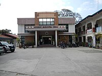
Municipal hall
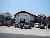
Public market

Town plaza
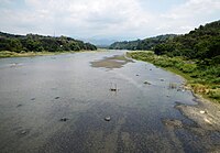
Aringay River
Street view


Notable people[]
- Diego Silang
- Gloria Díaz - Miss Philippines 1969, Miss Universe 1969
- Elpidio Quirino
References[]
- ^ Municipality of Aringay | (DILG)
- ^ "2015 Census of Population, Report No. 3 – Population, Land Area, and Population Density" (PDF). Philippine Statistics Authority. Quezon City, Philippines. August 2016. ISSN 0117-1453. Archived (PDF) from the original on May 25, 2021. Retrieved July 16, 2021.
- ^ Jump up to: a b c Census of Population (2020). "Region I (Ilocos Region)". Total Population by Province, City, Municipality and Barangay. PSA. Retrieved 8 July 2021.
- ^ https://psa.gov.ph/sites/default/files/City%20and%20Municipal-level%20Small%20Area%20Poverty%20Estimates_%202009%2C%202012%20and%202015_0.xlsx; publication date: 10 July 2019; publisher: Philippine Statistics Authority.
- ^ Guillermo, Artemio R. (2012). Historical dictionary of the Philippines (3rd ed.). Lanham, Md.: Scarecrow Press. p. 401. ISBN 978-0-8108-7511-1. OCLC 774293494.
- ^ "Aringay: Average Temperatures and Rainfall". Meteoblue. Retrieved 26 April 2020.
- ^ "2010 Census of Population and Housing: Population Counts - Cordillera Administrative Region" (PDF). Philippine Statistics Authority, April 4, 2012. Archived from the original (PDF) on 26 June 2015. Retrieved 16 November 2014.
- ^ Census of Population (2015). "Region I (Ilocos Region)". Total Population by Province, City, Municipality and Barangay. PSA. Retrieved 20 June 2016.
- ^ Census of Population and Housing (2010). "Region I (Ilocos Region)". Total Population by Province, City, Municipality and Barangay. NSO. Retrieved 29 June 2016.
- ^ Censuses of Population (1903–2007). "Region I (Ilocos Region)". Table 1. Population Enumerated in Various Censuses by Province/Highly Urbanized City: 1903 to 2007. NSO.
- ^ "Province of La Union". Municipality Population Data. Local Water Utilities Administration Research Division. Retrieved 17 December 2016.
- ^ "Poverty incidence (PI):". Philippine Statistics Authority. Retrieved 28 December 2020.
- ^ https://psa.gov.ph/sites/default/files/NSCB_LocalPovertyPhilippines_0.pdf; publication date: 29 November 2005; publisher: Philippine Statistics Authority.
- ^ https://psa.gov.ph/sites/default/files/2003%20SAE%20of%20poverty%20%28Full%20Report%29_1.pdf; publication date: 23 March 2009; publisher: Philippine Statistics Authority.
- ^ https://psa.gov.ph/sites/default/files/2006%20and%202009%20City%20and%20Municipal%20Level%20Poverty%20Estimates_0_1.pdf; publication date: 3 August 2012; publisher: Philippine Statistics Authority.
- ^ https://psa.gov.ph/sites/default/files/2012%20Municipal%20and%20City%20Level%20Poverty%20Estima7tes%20Publication%20%281%29.pdf; publication date: 31 May 2016; publisher: Philippine Statistics Authority.
- ^ https://psa.gov.ph/sites/default/files/City%20and%20Municipal-level%20Small%20Area%20Poverty%20Estimates_%202009%2C%202012%20and%202015_0.xlsx; publication date: 10 July 2019; publisher: Philippine Statistics Authority.
- ^ Elias, Jun (July 10, 2014). "Bill seeks to merge 2 La Union towns into component city". PhilStar Global. Retrieved January 28, 2021.
External links[]
| Wikimedia Commons has media related to Aringay, La Union. |
- Aringay Profile at PhilAtlas.com
- Philippine Standard Geographic Code
- Philippine Census Information
- Local Governance Performance Management System
| show Places adjacent to Aringay |
|---|
| show Authority control |
|---|
- Municipalities of La Union
- Populated places established in 1641
- 1641 establishments in the Spanish Empire