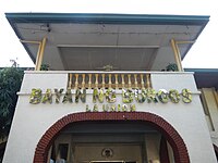
Burgos, La Union
Burgos
Disdis | |
|---|---|
| Municipality of Burgos | |
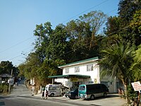
 Burgos town center along Naguilian Road | |
 Seal | |
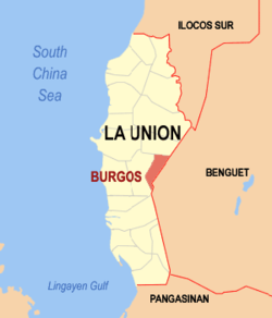 Map of La Union with Burgos highlighted | |
OpenStreetMap  | |
 Burgos Location within the Philippines | |
| Coordinates: 16°31′30″N 120°27′30″E / 16.525°N 120.4583°ECoordinates: 16°31′30″N 120°27′30″E / 16.525°N 120.4583°E | |
| Country | Philippines |
| Region | Ilocos Region |
| Province | La Union |
| District | 2nd district |
| Named for | José Burgos |
| Barangays | 12 (see Barangays) |
| Government | |
| • Type | Sangguniang Bayan |
| • Mayor | Robert B. Madarang Jr. |
| • Vice Mayor | Isidro C. delos Reyes |
| • Representative | Sandra Y. Eriguel |
| • Municipal Council | Members |
| • Electorate | 7,269 voters (2019) |
| Area | |
| • Total | 70.80 km2 (27.34 sq mi) |
| Elevation | 336 m (1,102 ft) |
| Highest elevation | 1,010 m (3,310 ft) |
| Lowest elevation | 21 m (69 ft) |
| Population (2020 census) [3] | |
| • Total | 9,006 |
| • Density | 130/km2 (330/sq mi) |
| • Households | 1,747 |
| Economy | |
| • Income class | 5th municipal income class |
| • Poverty incidence | 10.11% (2015)[4] |
| • Revenue | ₱69,933,063.40 (2020) |
| • Assets | ₱243,429,198.78 (2020) |
| • Expenditure | ₱76,962,468.81 (2020) |
| • Liabilities | ₱19,509,569.76 (2020) |
| Service provider | |
| • Electricity | La Union Electric Cooperative (LUELCO) |
| Time zone | UTC+8 (PST) |
| ZIP code | 2510 |
| PSGC | |
| IDD : area code | +63 (0)72 |
| Native languages | Ilocano Tagalog |
| Website | www |

Burgos, officially the Municipality of Burgos (Ilocano: Ili ti Burgos; Filipino: Bayan ng Burgos), is a 5th class municipality in the province of La Union, Philippines. According to the 2020 census, it has a population of 9,006 people. [3]
Barangays[]
- Agpay
- Bilis
- Caoayan
- Dalacdac
- Delles
- Imelda
- Libtong
- Linuan
- New Poblacion
- Old Poblacion
- Lower Tumapoc
- Upper Tumapoc
Climate[]
| Climate data for Burgos, La Union | |||||||||||||
|---|---|---|---|---|---|---|---|---|---|---|---|---|---|
| Month | Jan | Feb | Mar | Apr | May | Jun | Jul | Aug | Sep | Oct | Nov | Dec | Year |
| Average high °C (°F) | 28 (82) |
29 (84) |
30 (86) |
31 (88) |
29 (84) |
29 (84) |
27 (81) |
27 (81) |
27 (81) |
28 (82) |
29 (84) |
28 (82) |
29 (83) |
| Average low °C (°F) | 18 (64) |
19 (66) |
21 (70) |
23 (73) |
23 (73) |
23 (73) |
23 (73) |
23 (73) |
23 (73) |
22 (72) |
20 (68) |
19 (66) |
21 (70) |
| Average precipitation mm (inches) | 42 (1.7) |
48 (1.9) |
74 (2.9) |
110 (4.3) |
269 (10.6) |
275 (10.8) |
362 (14.3) |
325 (12.8) |
330 (13.0) |
306 (12.0) |
126 (5.0) |
61 (2.4) |
2,328 (91.7) |
| Average rainy days | 11.2 | 12.0 | 17.1 | 21.2 | 27.1 | 26.8 | 28.1 | 27.0 | 26.0 | 24.5 | 17.7 | 12.4 | 251.1 |
| Source: Meteoblue [5] | |||||||||||||
Demographics[]
| Year | Pop. | ±% p.a. |
|---|---|---|
| 1903 | 8 | — |
| 1918 | 2,256 | +45.66% |
| 1939 | 1,774 | −1.14% |
| 1948 | 1,348 | −3.01% |
| 1960 | 2,124 | +3.86% |
| 1970 | 3,160 | +4.05% |
| 1975 | 3,570 | +2.48% |
| 1980 | 4,149 | +3.05% |
| 1990 | 5,410 | +2.69% |
| 1995 | 6,086 | +2.23% |
| 2000 | 6,748 | +2.24% |
| 2007 | 8,261 | +2.83% |
| 2010 | 7,850 | −1.84% |
| 2015 | 8,067 | +0.52% |
| 2020 | 9,006 | +2.19% |
| Source: Philippine Statistics Authority [6] [7] [8][9] | ||
In the 2020 census, the population of Burgos, La Union, was 9,006 people, [3] with a density of 130 inhabitants per square kilometre or 340 inhabitants per square mile.
Economy[]
| Poverty Incidence of Burgos | |
| Source: Philippine Statistics Authority[10][11][12][13][14][15] | |
Major roads[]
Gallery[]
|


References[]
- ^ Municipality of Burgos | (DILG)
- ^ "2015 Census of Population, Report No. 3 – Population, Land Area, and Population Density" (PDF). Philippine Statistics Authority. Quezon City, Philippines. August 2016. ISSN 0117-1453. Archived (PDF) from the original on May 25, 2021. Retrieved July 16, 2021.
- ^ a b c Census of Population (2020). "Region I (Ilocos Region)". Total Population by Province, City, Municipality and Barangay. PSA. Retrieved 8 July 2021.
- ^ https://psa.gov.ph/sites/default/files/City%20and%20Municipal-level%20Small%20Area%20Poverty%20Estimates_%202009%2C%202012%20and%202015_0.xlsx; publication date: 10 July 2019; publisher: Philippine Statistics Authority.
- ^ "Burgos: Average Temperatures and Rainfall". Meteoblue. Retrieved 26 April 2020.
- ^ Census of Population (2015). "Region I (Ilocos Region)". Total Population by Province, City, Municipality and Barangay. PSA. Retrieved 20 June 2016.
- ^ Census of Population and Housing (2010). "Region I (Ilocos Region)". Total Population by Province, City, Municipality and Barangay. NSO. Retrieved 29 June 2016.
- ^ Censuses of Population (1903–2007). "Region I (Ilocos Region)". Table 1. Population Enumerated in Various Censuses by Province/Highly Urbanized City: 1903 to 2007. NSO.
- ^ "Province of La Union". Municipality Population Data. Local Water Utilities Administration Research Division. Retrieved 17 December 2016.
- ^ "Poverty incidence (PI):". Philippine Statistics Authority. Retrieved 28 December 2020.
- ^ https://psa.gov.ph/sites/default/files/NSCB_LocalPovertyPhilippines_0.pdf; publication date: 29 November 2005; publisher: Philippine Statistics Authority.
- ^ https://psa.gov.ph/sites/default/files/2003%20SAE%20of%20poverty%20%28Full%20Report%29_1.pdf; publication date: 23 March 2009; publisher: Philippine Statistics Authority.
- ^ https://psa.gov.ph/sites/default/files/2006%20and%202009%20City%20and%20Municipal%20Level%20Poverty%20Estimates_0_1.pdf; publication date: 3 August 2012; publisher: Philippine Statistics Authority.
- ^ https://psa.gov.ph/sites/default/files/2012%20Municipal%20and%20City%20Level%20Poverty%20Estima7tes%20Publication%20%281%29.pdf; publication date: 31 May 2016; publisher: Philippine Statistics Authority.
- ^ https://psa.gov.ph/sites/default/files/City%20and%20Municipal-level%20Small%20Area%20Poverty%20Estimates_%202009%2C%202012%20and%202015_0.xlsx; publication date: 10 July 2019; publisher: Philippine Statistics Authority.
External links[]
| Wikimedia Commons has media related to Burgos, La Union. |
- Burgos Profile at PhilAtlas.com
- Philippine Standard Geographic Code
- Philippine Census Information
- Local Governance Performance Management System
Places adjacent to Burgos, La Union | ||||||||||||||||
|---|---|---|---|---|---|---|---|---|---|---|---|---|---|---|---|---|
| ||||||||||||||||
San Fernando (capital) | |
| Municipalities | |
| Component city | |
| Barangays | |
This article about a location in Ilocos region is a stub. You can help Wikipedia by . |
Categories:
- Municipalities of La Union
- Philippines geography stubs