Arnala fort
This article needs additional citations for verification. (September 2020) |
| Arnala fort | |
|---|---|
| Part of Portuguese India | |
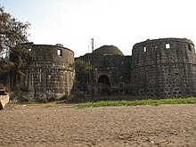
 Arnala fort bastion viewed through one of the fort's windows | |
 Arnala fort | |
| Coordinates | 19°27′57″N 72°43′57″E / 19.46577°N 72.73247°ECoordinates: 19°27′57″N 72°43′57″E / 19.46577°N 72.73247°E |
| Type | Indo-European style Sea fort |
| Site information | |
| Controlled by | Bijapur (1516-1530)
|
| Open to the public | Yes |
| Condition | Protected Ruins |
| Site history | |
| Built | 1516 AD |
| Built by | Sultan Mahmud Begda |
| Demolished | no |
| Battles/wars | 4 |
| Garrison information | |
| Current commander | none |
| Garrison | n/a |
| Occupants | n/a |

Arnala Fort is built on a off the port town of , located around 13 km (8 miles) north of Bassein, Maharashtra, India.[1] Being an island fort, it is also called Jaldurg or Janjire-Arnala. The Portuguese, who built the present fort, called the island Ilha das Vacas (Island of Cows).[2]
History[]
The island of Arnala, which has water on all four sides, belonged to Sultan Mahmud Begda of Gujarat.
The island was conquered by the Portuguese in 1530.
In 1737, after nearly two hundred years of Portuguese rule, the fort came under the control of the Marathas in 1737.
The fort was rebuilt by the first Bajirao.
In the middle of 1817, the fort came under the control of the British
In 1516 a local chieftain in Gujarat, Sultan Mahmud Begda, constructed the fort on the island, strategically located at the mouth of the Vaitarna river. In the 1530s the Portuguese had established their operations in the coastal area, headquartered at Fort Bassein, and soon gained control of the island. The Portuguese captain of Bassein donated the island to a Portuguese nobleman who tore down the old fort and began construction of a 700-by-700-foot (210 m × 210 m) fort. The nobleman never completed the fort. Still, it remained under Portuguese control for two centuries; they used it to control shipping and navigation along the northern Konkan coast.
During the late 17th and early 18th centuries, after a long struggle with the Mughal Empire, the Maratha Confederacy came to dominate the region. In 1737 the then Peshwa Baji Rao I sent his brother, Chimaji Appa, to take the Bassein Fort from the Portuguese. After winning the Battle of Vasai, his general, Shankarji Pant, persuaded Chimaji to launch an assault on Fort Arnala, for its strategic importance to the Maratha navy in assaulting Portuguese interests. Their first assault, coordinated with a Maratha naval force commanded by Govindji kasar & Manaji Agre, was routed by a superior Portuguese naval force. A second assault on the fort on 28 March 1737, caught the Portuguese by surprise and forced them to abandon the fort. The victory was commemorated by a plaque installed on the northern wall of the fort and is still visible today. The Marathas then rebuilt the fort, constructing three bastions Bahirav, Bhavani, and Bava.
The British captured the fort on 18 January 1781 during the First Anglo-Maratha War.[3] The Treaty of Salbai nominally returned the Arnala and Bassien forts to the Marathas. The Marathas controlled the fort until 1817.
During the Third Anglo-Maratha War, despite painstakingly defending the fort, the Marathas were finally forced to surrender the fort to the superior naval power of the British. The British formally regained the forts under the Treaty of Poona.
Today the fort is in a state of disrepair.[4]
Features[]

Water Reservoir and Shrines[]
There is a large octagonal fresh water reservoir inside the fort. Within its walls, are also the temples of Ambakeshwar, Bhavani and Shiva as well as Dargas (tombs) of Shah Ali and Hajji Ali. The 'paduka' or sacred sandals of Shrinity Anand are housed in a dome on the eastern face of the fort.
The Entrance[]
The main entrance of the fort faces approximately north.
The solid stone doorway is adorned with pictures of tigers and elephants.

Ramparts and Walls[]
The external ramparts are in a fairly good condition, and a roughly three-meter-wide path exists along the outer walls. .[5]
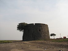
Southern Watch Tower[]
There exists a lone Martello tower about 550 meters from the main fort, on the southern end of the island. This tower has no entrance gate.
See also[]
- Bassein Fort
- Portuguese India
- List of forts in Maharashtra
References[]
- ^ "Friends of Forts". Archived from the original on 5 April 2009. Retrieved 3 February 2009.
- ^ Scholberg, Henry (1995). Fortress Portugal in India. NorthStar Publications. Retrieved 2 February 2009.
- ^ Naravane, M.S. (2014). Battles of the honourable East India Company. A.P.H. Publishing Corporation. p. 61. ISBN 9788131300343.
- ^ Naravane, A.V.H. (1998). The Maritime and Coastal Forts of India. APH Publishing. pp. 43–44. ISBN 81-7024-910-4. Retrieved 2 February 2009.
- ^ Kantak, M.R. (1993). The First Anglo-Maratha War, 1774-1783: A Military Study of Major Battles. Popular Prakashan. p. 150. ISBN 81-7154-696-X. Retrieved 2 February 2009.
External links[]
| Wikimedia Commons has media related to Fort Arnala. |
- Arnala Fort Pictures Archived 3 March 2016 at the Wayback Machine Pictures of Forts in Maharashtra
- Arnala Fort Page A Vasai Cultural Information Website in GeoCities.
- Arnala fort Trip A Blog Post on Arnala by a blogger.
- Arnala Fort & Jivdani Temple - * How to go, places to visit, things to do
- Trekking Tourism - Virar - विरार - ویرار
| Vijayanagara |
|
|---|---|
| Deccan sultanates | |
| Gujarat Sultanate | |
| Delhi Sultanate | |
| Nayak dynasty |
|
| Malwa Sultanate |
|
| Faruqi dynasty | |
| Rajputs |
|
| Maratha Empire | |
| Mughal Empire |
|
| Jat | |
| Kingdom of Mysore | |
| Siddi | |
| Travancore |
|
| Portuguese |
|
| Sikh Empire | |
| British Raj |
|
| Sur Empire |
|
| Eastern Ganga dynasty | |
| Ahom dynasty |
|
| Kakatiya dynasty |
|
| Bahmani Sultanate |
|
- Maratha Navy
- Forts in Palghar district
- Portuguese forts in India
- History of Vasai
- Rebuilt buildings and structures in India
- 16th-century forts in India
- 1530s establishments in Portuguese India
- Tourist attractions in Palghar district
- Forts in Maharashtra