Arundel railway station
Arundel | |
|---|---|
 | |
| Location | Arundel, Arun England |
| Grid reference | TQ024063 |
| Managed by | Southern |
| Platforms | 2 (was 3) |
| Other information | |
| Station code | ARU |
| Classification | DfT category E |
| History | |
| Opened | 3 August 1863 |
| Passengers | |
| 2016/17 | |
| 2017/18 | |
| 2018/19 | |
| 2019/20 | |
| 2020/21 | |
| Notes | |
Passenger statistics from the Office of Rail and Road | |

Arundel railway station serves the market town of Arundel in West Sussex. The station is on the eastern side of the town, about 550 yards (500 m) from the High Street, across the River Arun. It is 58 miles 28 chains (93.9 km) down the line from London Bridge via Redhill.
The station is situated on the A27 and is the transport hub for many settlements in the Arun District area, including Angmering and Wick, for passengers joining London-bound services to the capital and Gatwick Airport. The station is served by the No. 9 Stagecoach bus service that operates between Arundel, Littlehampton, Rustington, and Shoreham; bus stops are outside the station on the A27.[1]
The station can accommodate 12 coach trains and is one of the few stations along the Arun Valley route that does not have coach restriction announcements.
History[]
Opened by the London, Brighton and South Coast Railway, it became part of the Southern Railway during the Grouping of 1923. The station then passed on to the Southern Region of British Railways on nationalisation in 1948.
When Sectorisation was introduced in the 1980s, the station was served by Network SouthEast until the Privatisation of British Railways.
Until 1978, most trains from Arundel to London were routed via Dorking and Sutton, which was slightly quicker than today's workings. However, since 1978, services now serve Gatwick Airport and Croydon, and passengers for Dorking and Sutton now take a connecting train at Horsham.
The current use of the station is for predominantly London or Gatwick Airport bound passenger traffic. Southbound trains currently only serve Ford, Barnham, and Bognor Regis. Passengers for Chichester, Portsmouth Harbour and Southampton have a change of train at Barnham. Currently, there are no direct trains to Littlehampton.
Upon opening, the Earl of Arundel/Duke of Norfolk created a decree that all passengers services passing through Arundel station must stop (not run fast), and this must remain in place for 150 years from this date. In 2013, at the expiring of this, trains began running fast from Barnham to Horsham, skipping all stations, including Arundel. Before this time, train splitting and adjoining used to happen at Barnham, with 1 portion coming from/going to Portsmouth and one portion coming from/going to Bognor Regis. With Arundel station now allowed to be skipped, the splitting/joining now happens at Horsham station. This means that although 2 trains an hour stop at Arundel, and 2 trains go fast through, it hasn't actually lost any frequency, although for the sections between Arundel and Horsham in the up direction, and Arundel and Barnham in the down direction, it has lost capacity, as well as passengers from Arundel not being regularly able to travel to stations past Barnham towards Southampton or Portsmouth
Services[]
All services at Arundel are operated by Southern using Class 377 EMUs.
The typical off-peak service in trains per hour is:[2]
- 2 tph to London Victoria via Horsham
- 2 tph to Bognor Regis
On Sundays, there is an hourly service in each direction, although southbound trains divide at Barnham before travelling to Bognor Regis and Portsmouth Harbour.
| Preceding station | Following station | |||
|---|---|---|---|---|
| Southern Arun Valley Line | ||||
Gallery[]
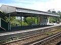
Waiting area at the northern end of the island platform.
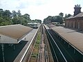
Southbound view from the station footbridge.

Northbound view from the island platform


References[]
- ^ "9 Bus Route & Timetable: Holmbush Shopping Centre - Arundel - Stagecoach". www.stagecoachbus.com.
- ^ Table 186 National Rail timetable, May 2020
- Butt, R. V. J. (1995). The Directory of Railway Stations: details every public and private passenger station, halt, platform and stopping place, past and present (1st ed.). Sparkford: Patrick Stephens Ltd. ISBN 978-1-85260-508-7. OCLC 60251199.
- Jowett, Alan (2000). Jowett's Nationalised Railway Atlas (1st ed.). Penryn, Cornwall: Atlantic Transport Publishers. ISBN 978-0-906899-99-1. OCLC 228266687.
- Station on navigable O.S. map
External links[]
| Wikimedia Commons has media related to Arundel railway station. |
- Train times and station information for Arundel railway station from National Rail
- Arundel Station in the 1866 edition of Bradshaw's Descriptive Railway Hand-Book of Great Britain & Ireland
- Arun District
- Railway stations in West Sussex
- Former London, Brighton and South Coast Railway stations
- Railway stations in Great Britain opened in 1863
- Railway stations served by Southern
- Arundel