Angmering railway station
Angmering | |
|---|---|
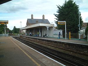 The main station building and platform one, as seen looking west from platform two (June 2007) | |
| Location | East Preston (Littlehampton), Arun England |
| Grid reference | TQ065029 |
| Owned by | Network Rail |
| Managed by | Southern |
| Platforms | 2 |
| Other information | |
| Station code | ANG |
| Classification | DfT category E |
| History | |
| Opened | 16 March 1846 |
| Passengers | |
| 2016/17 | |
| 2017/18 | |
| 2018/19 | |
| 2019/20 | |
| 2020/21 | |
| Notes | |
Passenger statistics from the Office of Rail and Road | |

Angmering is a railway station on the West Coastway Line, on the border of Angmering and East Preston in the district of Arun. It was opened in 1846. The station itself is situated about 0.6 miles (1 km) away from the centre of Angmering village, and is 15 miles 44 chains (25.0 km) down the line from Brighton. Buses depart for Angmering village hourly (Monday to Saturday off-peak), or walking to the village takes about 20 minutes. The station is located near the local secondary school The Angmering School, some of the students of which use the station daily to travel to and from school. Angmering station is also designed to be used by the residents of the nearby villages of Rustington and East Preston, with some of the station's signage actually reading 'Angmering for Rustington and East Preston'.
History[]
Opened by the London, Brighton and South Coast Railway, it became part of the Southern Railway during the Grouping of 1923. The line then passed on to the Southern Region of British Railways on nationalisation in 1948.
When Sectorisation was introduced, the station was served by Network SouthEast until the privatisation of British Rail.
Film of the station in 1937 is held by the Cinema Museum in London on spool HM 00072.
Services[]
Off-peak, all services at Angmering are operated by Southern using Class 313 and 377 EMUS.
The typical off-peak service in trains per hour is:[1]
- 2 tph to London Victoria via Gatwick Airport
- 2 tph to Brighton
- 2 tph to Littlehampton
- 1 tph to Southampton Central
- 1 tph to Portsmouth Harbour
During the peak periods, there are a small number of trains between Littlehampton, London Bridge and Bedford, operated by Thameslink.
| Preceding station | Following station | |||
|---|---|---|---|---|
| Southern West Coastway Line | ||||
| Southern West Coastway Line Littlehampton Branch | ||||
| Thameslink Bedford to Littlehampton Peak Hours Only | ||||
Former and current train companies[]
Southern currently manage the station and the trains that call at Angmering. Previously, South West Trains also used the station, running four trains per day to Brighton via Angmering until December 2007.
Facilities[]
There is a ticket office, a waiting room, toilets, buffet, car park, taxi rank and cycle storage.
Deaths[]
A local woman, Maureen Weselby, committed suicide by jumping in front of a Brighton-bound express, operated by South West Trains, in May 2006.[2]
A local teenager, Adam Blackwood, was killed here when a Littlehampton-bound Southern Class 377 train approaching the station knocked him down at a nearby pedestrian level crossing in early 2007.[3]
Another local, 16-year-old Megan Moore of Angmering, was killed after being dragged under the 22:17 London Victoria to Bognor Regis train just before midnight on 21 November 2009. Tributes have been paid on her personal Facebook profile and her "RIP Megan" group, which has nearly 9,000 members. Flowers and messages from friends and family were left outside the station.[4]
Gallery[]
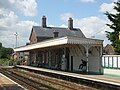
Closer view of the main station building and level crossing beyond.

The ticket office building and former station house, from the forecourt.

The substantial former station house, looking north from the level crossing.


References[]
- ^ "Timetable 24: Littlehampton and Worthing to Brighton and London" (PDF). Southern, December 2019.
- ^ "BBC News story about Weselby's death". Archived from the original on 14 October 2006. Retrieved 19 March 2007.
- ^ "BBC News story about Blackwood's death". 3 January 2007. Retrieved 1 January 2010.
- ^ "BBC News story about Moore's death". 23 November 2009. Archived from the original on 27 November 2009. Retrieved 1 January 2010.
- Butt, R. V. J. (1995). The Directory of Railway Stations: details every public and private passenger station, halt, platform and stopping place, past and present (1st ed.). Sparkford: Patrick Stephens Ltd. ISBN 978-1-85260-508-7. OCLC 60251199.
- Jowett, Alan (2000). Jowett's Nationalised Railway Atlas (1st ed.). Penryn, Cornwall: Atlantic Transport Publishers. ISBN 978-0-906899-99-1. OCLC 228266687.
- Station on navigable O.S. map
External links[]
| Wikimedia Commons has media related to Angmering railway station. |
- Train times and station information for Angmering railway station from National Rail
- Arun District
- Railway stations in West Sussex
- Former London, Brighton and South Coast Railway stations
- Railway stations in Great Britain opened in 1846
- Railway stations served by Southern
- 1846 establishments in England