Atid
Atid
Etéd | |
|---|---|
 | |
 Location in Harghita County | |
 Atid Location in Romania | |
| Coordinates: 46°27′0″N 25°3′0″E / 46.45000°N 25.05000°ECoordinates: 46°27′0″N 25°3′0″E / 46.45000°N 25.05000°E | |
| Country | Romania |
| County | Harghita |
| Government | |
| • Mayor (2020–2024) | Attila Szilveszter[1] (UDMR) |
| Area | 140.28 km2 (54.16 sq mi) |
| Population (2011)[2] | 2,705 |
| • Density | 19/km2 (50/sq mi) |
| Time zone | EET/EEST (UTC+2/+3) |
| Postal code | 537005 |
| Area code | +40 266 |
| Vehicle reg. | HR |
| Website | www |

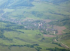
Atid (Hungarian: Etéd, pronounced [ˈɛteːd] (![]() listen)) is a commune in Harghita County, Romania. It lies in the Székely Land, an ethno-cultural region in eastern Transylvania.
listen)) is a commune in Harghita County, Romania. It lies in the Székely Land, an ethno-cultural region in eastern Transylvania.
Component villages[]
The commune is composed of five villages:
| In Romanian | In Hungarian |
|---|---|
| Atid | Etéd |
| Crișeni | Kőrispatak |
| Cușmed | Küsmöd |
| Inlăceni | Énlaka |
| Șiclod | Siklód |
History[]
From ancient times the area was populated by Dacians. After the Roman conquest of Dacia, the Romans imposed their control in the area by constructing a fort known as Praetoria Augusta in Inlăceni village. The fort was discovered in 1858.

The villages were historically part of the Székely Land region of Transylvania province. They belonged to Udvarhely district until the administrative reform of Transylvania in 1876, when they fell within Udvarhely County in the Kingdom of Hungary. After the Treaty of Trianon of 1920, they became part of Romania and fell within Odorhei County during the interwar period. In 1940, the second Vienna Award granted Northern Transylvania to Hungary, which held it until 1944. After Soviet occupation, the Romanian administration returned, and the commune became officially part of Romania in 1947. Between 1952 and 1960, the commune fell within the Magyar Autonomous Region, between 1960 and 1968 the Mureș-Magyar Autonomous Region. In 1968, the province was abolished, and since then, the commune has been part of Harghita County.
The Reformed church was built in 1802, on the site of a 17th-century church destroyed in the great fire of 8 September 1792. The Roman Catholic parish church was built in 1876 in honor of St. Michael. Its tower was completed in 1889. The village used to be famous for its weekly fairs.
Demographics[]
The commune has an absolute Székely Hungarian majority. According to the 2002 census it has a population of 2,837 of which 98.37% or 2,791 are Hungarian.[3][4]
Villages[]
Inlăceni[]
Inlăceni (Hungarian: Énlaka, Hungarian pronunciation: [ˈeːnlɒkɒ]) had 228 inhabitants in 1992, all of them Székely Hungarians. As in the village's vicinity, most inhabitants belong to the Unitarian Church of Transylvania.[5]

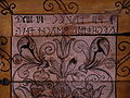
Unitarian church

Unitarian church interior

Unitarian church interior


References[]
- ^ "Results of the 2020 local elections". Central Electoral Bureau. Retrieved 9 June 2021.
- ^ "Populaţia stabilă pe judeţe, municipii, oraşe şi localităti componenete la RPL_2011" (in Romanian). National Institute of Statistics. Retrieved 4 February 2014.
- ^ "Archived copy". Archived from the original on 2010-06-06. Retrieved 2010-05-30.CS1 maint: archived copy as title (link)
- ^ "Etnikai statisztikák" (in Hungarian). Árpád E. Varga. Retrieved 2010-06-15.
- ^ Árpád E. Varga: Ethnic statistics
| Wikimedia Commons has media related to Atid, Harghita. |

- Communes in Harghita County
- Localities in Transylvania
- Székely communities