Avoca, Minnesota
Avoca | |
|---|---|
City | |
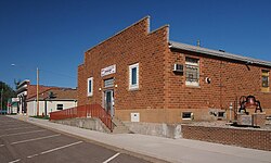 Avoca's community hall on SW 2nd Street | |
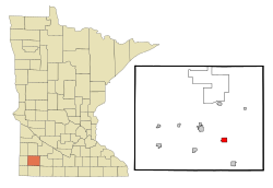 Location of Avoca within Murray County, Minnesota | |
| Coordinates: 43°56′56″N 95°38′49″W / 43.94889°N 95.64694°W | |
| Country | United States |
| State | Minnesota |
| County | Murray |
| Government | |
| • Type | Mayor – Council |
| • Mayor | Roger Lindmeier |
| Area | |
| • Total | 1.17 sq mi (3.03 km2) |
| • Land | 0.96 sq mi (2.50 km2) |
| • Water | 0.20 sq mi (0.53 km2) |
| Elevation | 1,539 ft (469 m) |
| Population | |
| • Total | 147 |
| • Estimate (2019)[5] | 135 |
| • Density | 140.04/sq mi (54.07/km2) |
| Time zone | UTC-6 (Central (CST)) |
| • Summer (DST) | UTC-5 (CDT) |
| ZIP code | 56114 |
| Area code(s) | 507 |
| FIPS code | 27-03052[3] |
| GNIS feature ID | 0639539[4] |

Avoca (/ˈævoʊkə/) is a city in Murray County, Minnesota, United States. The population was 147 at the 2010 census.[6]
Geography[]
According to the United States Census Bureau, the city has a total area of 1.17 square miles (3.03 km2), of which 0.97 square miles (2.51 km2) is land and 0.20 square miles (0.52 km2) is water.[7] It is just south of Lime Lake.
U.S. Highway 59 and Murray County Roads 6 and 38 are the main routes in the community.
Demographics[]
| Historical population | |||
|---|---|---|---|
| Census | Pop. | %± | |
| 1880 | 135 | — | |
| 1890 | 170 | 25.9% | |
| 1900 | 338 | 98.8% | |
| 1910 | 212 | −37.3% | |
| 1920 | 270 | 27.4% | |
| 1930 | 285 | 5.6% | |
| 1940 | 323 | 13.3% | |
| 1950 | 281 | −13.0% | |
| 1960 | 226 | −19.6% | |
| 1970 | 203 | −10.2% | |
| 1980 | 201 | −1.0% | |
| 1990 | 150 | −25.4% | |
| 2000 | 146 | −2.7% | |
| 2010 | 147 | 0.7% | |
| 2019 (est.) | 135 | [5] | −8.2% |
| U.S. Decennial Census | |||
2010 census[]
As of the census[2] of 2010, there were 147 people, 61 households, and 36 families residing in the city. The population density was 151.5 inhabitants per square mile (58.5/km2). There were 77 housing units at an average density of 79.4 per square mile (30.7/km2). The racial makeup of the city was 93.2% White, 2.0% from other races, and 4.8% from two or more races. Hispanic or Latino of any race were 5.4% of the population.
There were 61 households, of which 31.1% had children under the age of 18 living with them, 50.8% were married couples living together, 3.3% had a female householder with no husband present, 4.9% had a male householder with no wife present, and 41.0% were non-families. 37.7% of all households were made up of individuals, and 11.5% had someone living alone who was 65 years of age or older. The average household size was 2.41 and the average family size was 3.22.
The median age in the city was 44.1 years. 26.5% of residents were under the age of 18; 8.3% were between the ages of 18 and 24; 17.7% were from 25 to 44; 36% were from 45 to 64; and 11.6% were 65 years of age or older. The gender makeup of the city was 51.0% male and 49.0% female.
2000 census[]
As of the census[3] of 2000, there were 146 people, 67 households, and 38 families residing in the city. The population density was 134.3 people per square mile (51.7/km2). There were 73 housing units at an average density of 67.2 per square mile (25.9/km2). The racial makeup of the city was 100.00% White.
There were 67 households, out of which 23.9% had children under the age of 18 living with them, 47.8% were married couples living together, 7.5% had a female householder with no husband present, and 41.8% were non-families. 37.3% of all households were made up of individuals, and 13.4% had someone living alone who was 65 years of age or older. The average household size was 2.18 and the average family size was 2.82.
In the city, the population was spread out, with 21.9% under the age of 18, 2.7% from 18 to 24, 27.4% from 25 to 44, 32.9% from 45 to 64, and 15.1% who were 65 years of age or older. The median age was 44 years. For every 100 females, there were 117.9 males. For every 100 females age 18 and over, there were 119.2 males.
The median income for a household in the city was $29,375, and the median income for a family was $33,750. Males had a median income of $25,313 versus $16,667 for females. The per capita income for the city was $13,184. There were 7.5% of families and 12.6% of the population living below the poverty line, including 11.8% of under eighteens and 12.5% of those over 64.
History[]

In 1879, Avoca was named for the village of Avoca in County Wicklow, Ireland.[8]
A Catholic school for Indian girls ran circa 1882-1896 and later reopened in 1905 as a boys military school until it was destroyed by fire in 1910.[9][10][11][12]
St. Rose of Lima Catholic Church suffered a fire in 1889 but was rebuilt though it is now closed and the structure torn down.[9] Three former Lutheran churches long ago merged into Faith Evangelical Lutheran Church (ELCA), which closed in August, 2018.[13] The nondenominational Word of Faith Fellowship, established 1983, is the only church currently in town.
A public school was built in 1894, but is no longer in use.[14]
Avoca suffered two devastating fires, first in 1907 then again in 1952.[15]
Politics[]
Avoca is located in Minnesota's 1st congressional district, represented by Mankato educator Tim Walz, a Democrat. At the state level, Avoca is located in Senate District 22, represented by Republican Doug Magnus, and in House District 22A, represented by Republican Joe Schomacker.
References[]
- ^ "2019 U.S. Gazetteer Files". United States Census Bureau. Retrieved July 26, 2020.
- ^ Jump up to: a b "U.S. Census website". United States Census Bureau. Retrieved 2012-11-13.
- ^ Jump up to: a b "U.S. Census website". United States Census Bureau. Retrieved 2008-01-31.
- ^ "US Board on Geographic Names". United States Geological Survey. 2007-10-25. Retrieved 2008-01-31.
- ^ Jump up to: a b "Population and Housing Unit Estimates". United States Census Bureau. May 24, 2020. Retrieved May 27, 2020.
- ^ "2010 Census Redistricting Data (Public Law 94-171) Summary File". American FactFinder. United States Census Bureau. Retrieved 27 April 2011.[dead link]
- ^ "US Gazetteer files 2010". United States Census Bureau. Archived from the original on 2012-01-25. Retrieved 2012-11-13.
- ^ Upham, Warren (1920). Minnesota Geographic Names: Their Origin and Historic Significance. Minnesota Historical Society. p. 364.
- ^ Jump up to: a b Guide to Catholic-Related Records in the Midwest about Native Americans (PDF), retrieved 2012-09-20
- ^ The Catholic School for Girls, Avoca, Minnesota, retrieved 2012-09-20
- ^ St. Bernard's Hall school, Avoca, Minnesota, retrieved 2012-09-20
- ^ The Lost Pipestone of Avoca, Minnesota, retrieved 2012-09-20
- ^ "Faith Evangelical Lutheran in Avoca to hold final service Sunday". Retrieved 2021-01-11.
- ^ "Schoolhouses". Retrieved 2014-09-18.
- ^ Murray County, MN - Avoca, archived from the original on 2009-01-25, retrieved 2009-08-13
| show Municipalities and communities of Murray County, Minnesota, United States |
|---|

Coordinates: 43°56′55″N 95°38′44″W / 43.94861°N 95.64556°W
| show Authority control |
|---|
- Cities in Minnesota
- Cities in Murray County, Minnesota