Baýramaly
Baýramaly | |
|---|---|
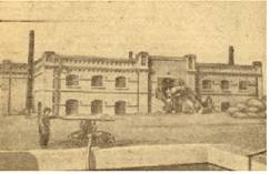 Baýramaly in the late 1800s | |
 Baýramaly Location in Turkmenistan | |
| Coordinates: 37°37′N 62°09′E / 37.617°N 62.150°E | |
| Country | |
| Province | Mary Province |
| District | Baýramaly District |
| Elevation | 233 m (764 ft) |
| Population (2009) | |
| • Total | 88,486 |
| Time zone | UTC+5 (+5) |

Baýramaly (formerly Bayram-Ali, Turkmen: Baýramaly, earlier Bahrām Ali [1]) is a city in and the seat of Baýramaly District, Mary Province, Turkmenistan. It lies about 27 km east of the provincial capital Mary, along the main railway line from Ashgabat to Tashkent. In 2009, its population was estimated at 88,486 (up from 43,824 in the 1989 census).[2]
Etymology[]
Bayramaly is a masculine name. According to Atanyyazow, Bayramaly ruled Mary in the 18th century, from 1782 to 1785.[3]
Overview[]
The city is located in a dry oasis formed by the Murghab River. Baýramaly is a climatic spa and visitors are often sent to the city for treatment of chronic kidney disease, acute forms of nephritis and nephrosis, hypertension, renal tuberculosis, and problems of blood circulation.[4] The Baýramaly Sanitorium (Turkmen: Baýramaly Şypahanasy) has been in operation since 1933. In 2010 the sanitorium underwent renovation and two new buildings were added. The sanitorium specializes in ailments of the kidneys and urinary tract, diseases of the cardiovascular system, and diseases of the musculoskeletal system.[5]
Climate[]
Baýramaly has a cold semi-arid climate (Köppen climate classification BSk), with cool winters and very hot summers. Rainfall is generally light and erratic, and occurs mainly in the winter and autumn months.
| Climate data for Baýramaly | |||||||||||||
|---|---|---|---|---|---|---|---|---|---|---|---|---|---|
| Month | Jan | Feb | Mar | Apr | May | Jun | Jul | Aug | Sep | Oct | Nov | Dec | Year |
| Record high °C (°F) | 28.0 (82.4) |
31.8 (89.2) |
37.0 (98.6) |
40.5 (104.9) |
50.0 (122.0) |
50.0 (122.0) |
47.5 (117.5) |
45.7 (114.3) |
44.0 (111.2) |
39.6 (103.3) |
35.2 (95.4) |
29.0 (84.2) |
50.0 (122.0) |
| Average high °C (°F) | 8.4 (47.1) |
11.4 (52.5) |
16.9 (62.4) |
24.7 (76.5) |
31.4 (88.5) |
36.2 (97.2) |
38.1 (100.6) |
36.1 (97.0) |
31.0 (87.8) |
24.1 (75.4) |
16.8 (62.2) |
10.3 (50.5) |
23.8 (74.8) |
| Daily mean °C (°F) | 1.9 (35.4) |
4.6 (40.3) |
9.9 (49.8) |
17.2 (63.0) |
23.6 (74.5) |
28.5 (83.3) |
30.5 (86.9) |
28.1 (82.6) |
22.1 (71.8) |
15.0 (59.0) |
8.7 (47.7) |
4.0 (39.2) |
16.2 (61.1) |
| Average low °C (°F) | −2.7 (27.1) |
−0.5 (31.1) |
4.1 (39.4) |
10.2 (50.4) |
15.3 (59.5) |
19.5 (67.1) |
21.7 (71.1) |
19.2 (66.6) |
12.9 (55.2) |
7.0 (44.6) |
2.1 (35.8) |
−1.0 (30.2) |
9.0 (48.2) |
| Record low °C (°F) | −26.3 (−15.3) |
−24.8 (−12.6) |
−16.8 (1.8) |
−3.6 (25.5) |
2.2 (36.0) |
7.6 (45.7) |
11.7 (53.1) |
7.4 (45.3) |
−1.8 (28.8) |
−8.3 (17.1) |
−21.5 (−6.7) |
−23.0 (−9.4) |
−26.3 (−15.3) |
| Average precipitation mm (inches) | 28.7 (1.13) |
24.9 (0.98) |
35.3 (1.39) |
26.0 (1.02) |
13.3 (0.52) |
1.1 (0.04) |
0.1 (0.00) |
0.1 (0.00) |
0.8 (0.03) |
6.7 (0.26) |
13.6 (0.54) |
23.2 (0.91) |
173.8 (6.82) |
| Average precipitation days (≥ 0.1 mm) | 7.2 | 6.2 | 5.9 | 3.8 | 2.3 | 0.5 | 0.2 | 0.3 | 0.3 | 2.2 | 5.1 | 6.1 | 40.1 |
| Average relative humidity (%) | 73.5 | 67.3 | 57.7 | 51.6 | 40.6 | 31.7 | 30.3 | 29.4 | 34.7 | 46.1 | 63.1 | 72.8 | 49.9 |
| Mean monthly sunshine hours | 129.7 | 137.4 | 168.9 | 217.2 | 304.7 | 356.2 | 371.7 | 355.0 | 302.4 | 249.0 | 185.1 | 128.7 | 2,906 |
| Source 1: climatebase.ru[6] | |||||||||||||
| Source 2: NOAA (sun only, 1961-1990)[7] | |||||||||||||
Economy[]
The economy is based around food and construction materials industries.[4] Natural gas is also extracted in the area.
Sights[]
- Close to Baýramaly are the ruins of ancient Merv.
- 28 kilometres (17 mi) to the north is the mausoleum of Hudaýnazar Öwlüýä (early 12th century).[4]
People[]
- Nury Halmammedov
- Suleyman Nazarov Berdiyevich
- Dzhamaldin Khodzhaniyazov
- Alvina Shpady
References[]
- ^ 1929 Soviet Turkmenistan map
- ^ Population census 1989 Archived 2012-02-04 at WebCite, Demoscope Weekly, No. 359-360, 1–18 January 2009 (search for Туркменская ССР) (in Russian)
- ^ Atanyýazow, Soltanşa (1980). Түркменистаның Географик Атларының Дүшүндиришли Сөзлүги [Explanatory Dictionary of Geographic Names in Turkmenistan]. Ashgabat: Ылым. p. 54.
- ^ a b c Great Soviet Encyclopedia (in Russian)
- ^ ""Baýramaly" şypahanasy" (in Turkmen). Turkmenportal. 1 September 2012.
- ^ "Bayram-Ali, Turkmenistan". Climatebase.ru. Retrieved 10 February 2013.
- ^ "Climate Normals for Bayramaly". National Oceanic and Atmospheric Administration. Retrieved 10 February 2013.
Coordinates: 37°37′00″N 62°09′00″E / 37.6167°N 62.1500°E
- Populated places in Mary Region