Türkmenbaşy, Turkmenistan
Türkmenbaşy
Türkmenbaşy (in Turkmen) Түркменбаши Krasnovodsk (Красноводск) Kyzyl-Su Şagadam | |
|---|---|
        | |
 Türkmenbaşy Location in Turkmenistan | |
| Coordinates: 40°01′00″N 52°58′00″E / 40.01667°N 52.96667°E | |
| Country | |
| Region | Balkan |
| Founded | 1869 [1] [2] |
| Named for | Saparmurat Niyazov |
| Government | |
| • Type | Presidential[4] |
| • Mayor | Amangeldi Isaýew[5] |
| Elevation | 27 m (89 ft) |
| Population (2010) | |
| • Total | 73 000 |
| Time zone | UTC+05:00 (UTC+5) |
| • Summer (DST) | not observed |
| Postal code | 745000 [3] |
| Area code(s) | +993-243 |
| Vehicle registration | BN |

Türkmenbaşy (Turkmen Cyrillic: Түркменбашы, Turkmen Arabic; توركمنباشی, also spelled Turkmenbashi, a back-formation of the Cyrillic Түркменбаши), formerly known as Krasnovodsk (Russian: Красноводск), Kyzyl-Su, and Shagadam (Turkmen: Şagadam) is a city in Balkan Province in Turkmenistan, on the Türkmenbaşy Gulf of the Caspian Sea. It sits at an elevation of 27 metres (89 feet).[citation needed] The population (est 2004) was 86,800, mostly ethnic Russians, Armenians and Azeris. As the terminus of the Trans-Caspian Railway and site of a major seaport on the Caspian, it is an important transportation center. The city is also the site of Turkmenistan's largest oil refining complex.
This city should not be confused with the similarly named town of Türkmenbaşy (Turkmen: Türkmenbaşy şäherçesi), formerly called Janga (Russian: Джанга, Cyrillic Turkmen: Җанга), also in Balkan Province, or the city of Saparmyrat Türkmenbaşy adyndaky (formerly called Täzebazar) in Daşoguz Province.
History[]
In 1717, Russian Prince Alexander Bekovich-Cherkassky landed and established a secret fortified settlement on this location, where the dry bed of a former mouth of the Amu-Darya River once emptied into the Caspian Sea. His intent was to march an army up this dry riverbed and conquer the Khanate of Khiva. The expedition failed, and the Russians abandoned the settlement for over 150 years.
Krasnovodsk[]

In 1869, the Russians invaded a second time. Having captured the settlement, they named their fort Krasnovodsk (Красноводск), which is a Russian translation of the original name, Kyzyl-Su (Red Water). The fort, Krasnovodsk, served as Imperial Russia's base of operations against Khiva and Bukhara, as well as the semi-nomadic Turkmen tribes.
The railway had originally begun from Uzun-Ada on the Caspian Sea, but the terminus was shifted north to the harbour at Krasnovodsk.[6]
It fell to the Red Army in February 1920.
On November 21, 1939, Krasnovodsk Oblast was formed with its administrative center in Krasnovodsk. The oblast was repeatedly liquidated and restored (January 23, 1947, liquidated; April 4, 1952, restored; December 9, 1955, liquidated; December 27, 1973, restored; August 25, 1988, eliminated).
Türkmenbaşy[]
January 10, 1991, Balkan province was created, and on May 18, 1992, was designated a velayat (Turkmen: welaýat) with its capital in Balkanabat. On 8 October 1993, Krasnovodsk was renamed by President for Life Saparmurat Niyazov after his self-proclaimed title Türkmenbaşy ("Head of [all] Turkmens") by Resolution No. 904-XII of Turkmenistan Parliament.[7]
The second President of Turkmenistan, Gurbanguly Berdimuhamedow, pledged in July 2007 to invest $1 billion in a project slated to turn Türkmenbaşy into a major tourist resort. He ordered development of the Awaza tourist zone with 60 modern hotels to be built along a 16 km (10 mi) stretch of the Caspian Sea shoreline.[8][9] Aside from Awaza, Türkmenbaşy city has three modern hotels: Türkmenbaşy Hotel, Charlak Hotel, and the new Silk Road Hotel at the seaport, plus the old Soviet Hazar Hotel.
In recent years, the city has undergone large-scale reconstruction: historic district, entrance roads, vital infrastructure.[10] A new Turkish Park and the cascade of fountains.[11] By the end of 2012 Magtymguly Avenue had been completely renovated. The new route merged with the city's waterfront, Bahry Hazar, and from the west motorway junction at Balykçy Traffic Circle a dual carriageway leads westward out of the city along a dike across Soymonov Bay to Turkmenbashy Airport and to Awaza.[12] In 2014, the Oilworkers Palace of Culture, which was built in 1951, was renovated.[13]
The city is home of the Türkmendeňizderýaýollary Agency, part of the Government of Turkmenistan.[14]
Administrative divisions[]
As of July 2013 the city of Turkmenbashy was divided into two boroughs (Turkmen: etrap) - Awaza etraby (Avaza Borough) and Kenar etraby (Kenar Borough).[15] Awaza etraby, an area of 9660 hectares, includes the Awaza national tourist zone, Turkmenbashi International Airport and a small residential area. Kenar etraby, an area of 7262 hectares, includes the main part of the city of Turkmenbashy and the territory of the former town of Kenar. Each borough is headed by a presidentially appointed mayor (Turkmen: häkim).[16][17]
Kenar Borough also encompasses the Turkmenbashi International Seaport, including the Kenar Oil Loading Terminal as well as the Kenar Oil Storage and Loading Enterprise (Russian: Кенарское предприятие хранения и отгрузки нефтепродуктов, Turkmen: Kenar nebit önümlerini saklamak we iberiş kärhanasy).
Geography[]
Climate[]
Türkmenbaşy has a cold desert climate (BWk, according to the Köppen climate classification), with hot summers and chilly winters. The average temperatures are 3 °C in January and 28 °C in July. The average annual precipitation is 125 mm (5 in).
| hideClimate data for Türkmenbaşy (1981–2010) | |||||||||||||
|---|---|---|---|---|---|---|---|---|---|---|---|---|---|
| Month | Jan | Feb | Mar | Apr | May | Jun | Jul | Aug | Sep | Oct | Nov | Dec | Year |
| Record high °C (°F) | 20.7 (69.3) |
23.3 (73.9) |
29.0 (84.2) |
36.0 (96.8) |
40.7 (105.3) |
43.3 (109.9) |
44.7 (112.5) |
44.5 (112.1) |
43.5 (110.3) |
33.4 (92.1) |
28.1 (82.6) |
24.6 (76.3) |
44.7 (112.5) |
| Average high °C (°F) | 7.5 (45.5) |
8.7 (47.7) |
13.1 (55.6) |
19.9 (67.8) |
25.8 (78.4) |
31.6 (88.9) |
34.6 (94.3) |
34.5 (94.1) |
29.3 (84.7) |
21.5 (70.7) |
14.2 (57.6) |
9.1 (48.4) |
20.8 (69.4) |
| Daily mean °C (°F) | 3.3 (37.9) |
3.9 (39.0) |
7.7 (45.9) |
13.7 (56.7) |
19.5 (67.1) |
25.1 (77.2) |
28.2 (82.8) |
28.0 (82.4) |
22.7 (72.9) |
15.4 (59.7) |
9.3 (48.7) |
4.9 (40.8) |
15.1 (59.2) |
| Average low °C (°F) | −0.3 (31.5) |
−0.2 (31.6) |
3.2 (37.8) |
8.5 (47.3) |
13.6 (56.5) |
18.9 (66.0) |
22.2 (72.0) |
22.0 (71.6) |
16.7 (62.1) |
10.0 (50.0) |
5.0 (41.0) |
1.2 (34.2) |
10.1 (50.2) |
| Record low °C (°F) | −21.5 (−6.7) |
−21.9 (−7.4) |
−12.6 (9.3) |
−2.6 (27.3) |
0.9 (33.6) |
6.6 (43.9) |
14.1 (57.4) |
10.2 (50.4) |
3.3 (37.9) |
−3.1 (26.4) |
−12.1 (10.2) |
−16.3 (2.7) |
−21.9 (−7.4) |
| Average precipitation mm (inches) | 12 (0.5) |
13 (0.5) |
17 (0.7) |
16 (0.6) |
9 (0.4) |
3 (0.1) |
2 (0.1) |
5 (0.2) |
5 (0.2) |
11 (0.4) |
19 (0.7) |
14 (0.6) |
126 (5.0) |
| Average rainy days | 8 | 7 | 8 | 8 | 6 | 3 | 2 | 3 | 3 | 6 | 8 | 8 | 70 |
| Average snowy days | 4 | 4 | 1 | 0.1 | 0 | 0 | 0 | 0 | 0 | 0 | 0 | 2 | 11 |
| Average relative humidity (%) | 76 | 72 | 68 | 63 | 56 | 50 | 49 | 44 | 46 | 58 | 72 | 75 | 61 |
| Mean monthly sunshine hours | 136.6 | 139.0 | 172.6 | 227.0 | 303.2 | 347.0 | 344.0 | 330.2 | 294.1 | 228.8 | 161.9 | 124.0 | 2,808.4 |
| Source 1: Pogoda.ru.net [18] | |||||||||||||
| Source 2: NOAA (sun, 1961–1990)[19] | |||||||||||||
Economy[]
Western Turkmenistan has major petroleum and natural gas reserves, and Turkmenistan's largest oil refinery is in Türkmenbaşy. The Turkmenbashy oil refinery had a refining capacity of more than 10 million tons of oil per year as of May 2016. The refinery produces a range of products, including unleaded gasoline, petroleum coke, asphalt, laundry detergent, hydro-treated diesel, and lubricating oil.[20] The Turkmenbashy oil refinery is Turkmenistan's largest producer of liquid petroleum gas, accounting for two-thirds of total production with annual output of about 300 thousand tonnes.[21]

Since May 2018, the Shipbuilding[22] and Repairing Yard Balkan has been operating in the Turkmenbashi International Seaport. [23][24] The plant, the capacity of which allows to process 10,000 tons of steel per year, is calculated for the construction of 4-6 ships per year.[25] The production facility is capable of performing maintenance and repair work on 20-30 ships, by processing 2000 tons of steel per year. [26]
Sights[]
- Museum of Regional History
- Gate to former Krasnovodsk fort
- Beaches
- Khazar Nature Reserve
- Natural History Museum
The central office of the State Archives of the Balkan Region is located in Turkmenbashi. [27]
Religion[]
Russian Orthodox Church[]
The Church of St. Michael the Archangel is a gift of the Astrakhan diocese of the Russian Orthodox Church.[28] In 1895 it was moved to Krasnovodsk from a flooded peninsula Uzun Ada by Russian soldiers.[29]
Armenian Apostolic Church[]
The church was built in 1903. Currently it does not function and needs a major renovation.[30]
Sports[]
The city has Şagadam Stadium, at which is based the professional football club Şagadam FK.[31]
International sporting events[]
In 2014, first time in history Turkmenistan hosted World Tour Windsurfing. [32] [33]
Cellular[]
The city has one mobile operator : Altyn Asyr, which was implemented in 2007, and which has a 4G technology network with LTE since 2010. The 4G network covers all areas of the city and the Turkmenbashi International Airport.
Internet access services and cable TV are provided by the operator Turkmentelecom.[34] There is 1 internet cafe in the city.[35]
Education[]
Turkmenbashi Marine Secondary Vocational School[36] of Türkmendeňizderýaýollary Agency prepares specialists for the needs of the sea and river transport of Turkmenistan. [37] The term of study in accordance with the specialty is 2 or 2.5 years, on a paid basis.[38]
Culture[]
In the vicinity of the city of Turkmenbashi, the shooting of Soviet feature films Days of Eclipse by Alexander Sokurov, The Forty-First by Grigory Chukhray and Barkhan by Sanzhar Babayev (in the city itself) took place.
Transport[]
The public transport system and the relevant infrastructure in Turkmenbashi is primarily managed by the Turkmenawtoulaglary Agency.[39] Today, the city is served by an international airport and national rail services, municipal buses, minibuses, cabs, bike lanes.

The city is important as transport junction, formed by seaport with ferry terminal, airport and railway station.[40] The M37 highway links the seaport to points east. The P-18 highway runs west from the seaport to Awaza, then north to the border with Kazakhstan.
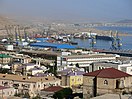
Turkmenbashi International Seaport[]
Türkmenbaşy is Turkmenistan's major seaport and sea link to the West. A ferry service connects Türkmenbaşy to Baku, Azerbaijan, which is about 260 kilometers across the Caspian Sea. It is the western terminus of the Trans-Caspian railway, which connects the city to Turkmenistan's capital Ashgabat and points further east.

In 1998, as part of its three-month expedition to the Caspian Sea, the Turkmenbashi International Seaport was visited by the Cousteau Society on the Alcyone ship). [41]
Passenger lines as of 2021 connected Turkmenbashi with the Port of Baku (Azerbaijan) and the Port of Olya (Russia). [42]
In 2014, a sea passenger terminal for domestic routes was opened in the port.[43] On the internal lines, the city is connected with the Hazar and .
In 2018, a new modernized seaport was opened, the largest in the Caspian Sea. The area of the new port is over 1.3 km2, and the total length of the berth is 3.6 km. The throughput capacity of the cargo terminal is up to 18 million tons per year. [44]
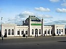
Turkmenbashi railway station[]

The rail station was built in 1895 by the architect Alexeï Leontievitch Benois. The station building is one of the most beautiful on the entire Central Asian railway. Railway station square is adjacent to the memorial to the soldiers who died during the Great Patriotic War. From Turkmenbashi daily runs train № 605/606 to Ashgabat. [45]
Turkmenbashi International Airport[]
Initially in 1940 the airport was located at the bottom of the plateau, near Krasnovodsk Hospital. During World War II it was transferred to the top of the plateau and the airfield was collocated with a Soviet Air Force base. In 2010 the airport was reconstructed and gained international status. It has two runways.[46] Turkmenistan Airlines provides direct flights from Turkmenbashi Airport to Ashgabat, Daşoguz, Mary, Istanbul and Türkmenabat. The airport can be reached by bus or car from the city, taking approximately 10–15 minutes by car.
Buses[]
Turkmenbashi 's bus network forms a crucial backbone of the city's transit system. For almost a decade, Hyundai Aero City buses of various modifications were serving the city.
The city is also connected to Ashgabat, Balkanabat and Garabogaz by bus. [47]
International relations[]
Consulates[]
Two consular offices are found in Türkmenbaşy.
 Consular Office of Russia
 Consulate of Kazakhstan[48]
Twin towns – Sister cities[]
See also[]
References[]
This article needs more complete citations for verification. (March 2017) |
- ^ [1]
- ^ [2]
- ^ [3]
- ^ "Türkmenistanyň Halk Maslahatynyň Çözgüdi HM-6 14 December 1992" (PDF).
- ^ [4]
- ^ "The United Service Magazine". 1900.
- ^ [5]
- ^ "Turkmenistan starts tourist drive". BBC News. 2007-07-23. Retrieved 2007-07-23.
- ^ Avaza Tourist Zone around Turkmenbashi Archived 2011-06-06 at the Wayback Machine
- ^ "Золотой век". www.turkmenistan.gov.tm.
- ^ "В Туркменбаши появится новая достопримечательность | Общество | ИП "ТУРКМЕНинформ"". www.turkmeninform.com.
- ^ "Золотой век". www.turkmenistan.gov.tm.
- ^ "Золотой век".
- ^ [6]
- ^ "Города с таким названием скоро не будет. Красноводск-Туркменбаши-Этрап Аваза города Туркменбаши+Этрап Кенар города Туркменбаши". Boroughs differ from ordinary municipal "districts" because boroughs are led by a presidentially appointed mayor (Turkmen: häkim) whereas ordinary municipal districts are subordinate to municipal authorities.
- ^ "Расширенное совещание по дальнейшему развитию Национальной туристической зоны «Аваза»" (in Russian). «Туркменистан: золотой век». 31 July 2013.
- ^ "Türkmenistanyň Prezidenti "Awaza" milli syýahatçylyk zolagyny mundan beýläk-de ösdürmek boýunça giňişleýin maslahat geçirdi" (in Turkmen). "Türkmenistan: Altyn asyr". 31 July 2013.
- ^ "Weather and Climate- The Climate of Turkmenbashi" (in Russian). Weather and Climate (Погода и климат). Archived from the original on December 6, 2016. Retrieved December 6, 2016.
- ^ "Turkmenbashy Climate Normals 1961–1990". National Oceanic and Atmospheric Administration. Retrieved April 1, 2015.
- ^ "Turkmenistan - Country Commercial Guide / Oil and Natural Gas Refining". U.S. Department of Commerce.
- ^ "В Туркменистане перевыполнен план по экспорту СПГ" (in Russian). Turkmenportal. 26 June 2020.
- ^ [7]
- ^ [8]
- ^ [9]
- ^ [10]
- ^ На судзаводе «Балкан» за 2 года отремонтировано более 80 судов
- ^ [11]
- ^ "Приходы".
- ^ "ТУРКМЕНБАШИНСКИЙ МИХАИЛО-АРХАНГЕЛЬСКИЙ ХРАМ - Древо".
- ^ "Президент Туркменистана поручил восстановить единственную уцелевшую в стране армянскую церковь - yerkramas.org". yerkramas.org.
- ^ ""Шагадам" cделал весомую заявку на "бронзу" | Спорт".
- ^ [12]
- ^ [13]
- ^ [14]
- ^ [15]
- ^ [16]
- ^ [17]
- ^ [18]
- ^ [19]
- ^ "Турецкая Polimeks построит в Туркмении аэропорт стоимостью 125 млн. евро (АвиаПорт)".
- ^ [20]
- ^ Первый туркменский паром запущен между Туркменбаши и Астраханью
- ^ В городе Туркменбаши открыт новый пассажирский морской вокзал
- ^ [21]
- ^ [22]
- ^ "Лента событий | Интернет-газета Turkmenistan.Ru".
- ^ [23]
- ^ [24]
- ^ "Sadraudzības pilsētas". jurmala.lv. Retrieved 26 April 2014. (in Latvian and English)
External links[]
| Wikimedia Commons has media related to Türkmenbaşy, Turkmenistan. |
| Wikivoyage has a travel guide for Turkmenbashi. |
Coordinates: 40°01′N 52°58′E / 40.017°N 52.967°E
| Authority control |
|---|
- Populated places in Balkan Region
- Transcaspian Oblast
- Populated places on the Caspian Sea
- Populated places established in 1869
- Populated coastal places in Turkmenistan
- 1869 establishments in the Russian Empire
- Port cities and towns of the Caspian Sea