Bacău County
This article includes a list of general references, but it remains largely unverified because it lacks sufficient corresponding inline citations. (December 2010) |
Bacău County
Județul Bacău | |
|---|---|
County | |
 | |
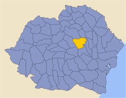
 Location of Bacău County in Romania | |
| Coordinates: 46°25′N 26°47′E / 46.42°N 26.78°ECoordinates: 46°25′N 26°47′E / 46.42°N 26.78°E | |
| Country | |
| Development region1 | Nord-Est |
| Historic region | Western Moldavia |
| Capital city (Reședință de județ) | Bacău |
| Government | |
| • Type | County Board |
| • President of the County Board | Sorin Braşoveanu (PSD) |
| • Prefect2 | Liviu Alexandru Miroseanu (PNL) |
| Area | |
| • Total | 6,621 km2 (2,556 sq mi) |
| Area rank | 14th in Romania |
| Population (2011 census[1]) | |
| • Total | 616,168 |
| • Rank | 9th in Romania |
| • Density | 93/km2 (240/sq mi) |
| Time zone | UTC+2 (EET) |
| • Summer (DST) | UTC+3 (EEST) |
| Postal Code | 60wxyz3 |
| Area code(s) | +40 x344 |
| Car Plates | BC5 |
| GDP | US$3.495 billion (2015) |
| GDP per capita | US$5,672 (2015) |
| Website | County Board County Prefecture |
| 1The development regions of Romania have no administrative role and were formed in order to manage funds from the European Union. 2As of 2007, the Prefect is not a politician, but a public functionary. He (or she) is not allowed to be a member of a political party, and is banned from engaging in any political activity in the first six months after his resignation (or exclusion) from the public functionary corps. 3w, x, y, and z are digits that indicate the city, the street, part of the street, or even the building of the address 4x is a digit indicating the operator: 2 for the former national operator, Romtelecom, and 3 for the other ground telephone networks 5used on both the plates of the vehicles that operate only in the county limits (like utility vehicles, ATVs, etc.), and the ones used outside the county | |
Bacău County (Romanian pronunciation: [baˈkəw] (![]() listen)) is a county (județ) of Romania, in Western Moldavia, with its capital city at Bacău. It has one commune, Ghimeș-Făget, in Transylvania.
listen)) is a county (județ) of Romania, in Western Moldavia, with its capital city at Bacău. It has one commune, Ghimeș-Făget, in Transylvania.
Demographics[]
| Year | County population[2] | Population density | Romanians | Romani people | Hungarians |
|---|---|---|---|---|---|
| 1948 | 414,996 | ||||
| 1956 | |||||
| 1966 | |||||
| 1977 | |||||
| 1992 | |||||
| 2002 | 113 / km² | 97.5% | 1.7% | 0.7% | |
| 2011[3] | 93 / km² | 96.1% | 1.7% | 0.68% |
Some estimates put the total number of Csangos at around 70,000 in 1987.[4]
Geography[]
This county has a total area of 6,621 km2.
The West side of the county are mountains from the Eastern Carpathian group. Here, along the valleys of the Oituz River and Trotuș River there are two important links between Moldavia and Transylvania. To the East side, the heights decrease and the lowest point can be found on the Siret River valley which crosses the county from North to South in the middle. On the East side there is the Moldavian Plateau crossed by many small rivers.
Flora and fauna[]
Bears, wolves, foxes, wild boars, and squirrels inhibit Bacău County's mountains (particularly in its rural Slanic-Moldova region); the remnants of the local deers are preserved in Mănăstirea Cașin.[5]
Neighbours[]

- Vaslui County in the East.
- Harghita County and Covasna County in the West.
- Neamț County in the North.
- Vrancea County in the South.
Economy[]
The county of Bacău was one of the most industrialized regions in the communist period and it remained Moldavia's most important industrial center ever since. There are two large oil refineries at Onești and Dărmănești. Following the collapse of the communist regime, Bacău continued to be the region's most important GDP supplier, but the county became more famous for the controversial figures involved in local economy than for its performance.
The predominant industries in the county are:
- The chemical and oil industry.
- Food industry.
- Construction materials industry.
- Wood and paper industry.
- Textile industry.
- Mechanical components industry.
- Aeronautics industry.
In Bacău county there are important reserves of oil and salt. Also coal is exploited.
Tourism[]
The main tourist destinations in the county are:
Politics[]
The Bacău County Council, renewed at the 2020 local elections, consists of 36 counsellors, with the following party composition:[6]
| Party | Seats | Current County Council | |||||||||||||||||
|---|---|---|---|---|---|---|---|---|---|---|---|---|---|---|---|---|---|---|---|
| Social Democratic Party (PSD) | 17 | ||||||||||||||||||
| PNL-USR PLUS Alliance | 11 | ||||||||||||||||||
| PRO Romania (PRO) | 3 | ||||||||||||||||||
| People's Movement Party (PMP) | 3 | ||||||||||||||||||
| Alliance of Liberals and Democrats (ALDE) | 2 | ||||||||||||||||||
People[]
- Gabriela Adameșteanu
- Vasile Alecsandri
- George Bacovia
- Radu Beligan
- Nadia Comăneci
- Loredana Groza
- Tristan Tzara
Administrative divisions[]


Bacău County has 3 municipalities, 5 towns and 85 communes
- Municipalities
- Towns
- Communes
- Agăș
- Ardeoani
- Asău
- Balcani
- Berești-Bistrița
- Berești-Tazlău
- Berzunţi
- Bârsănești
- Blăgești
- Bogdănești
- Brusturoasa
- Buciumi
- Buhoci
- Cașin
- Căiuți
- Cleja
- Colonești
- Corbasca
- Coțofănești
- Dămienești
- Dealu Morii
- Dofteana
- Faraoani
- Filipeni
- Filipești
- Găiceana
- Ghimeș-Făget
- Gârleni
- Glăvănești
- Gioseni
- Gura Văii
- Helegiu
- Hemeiuș
- Huruiești
- Horgești
- Izvoru Berheciului
- Itești
- Letea Veche
- Lipova
- Livezi
- Luizi-Călugăra
- Măgirești
- Măgura
- Mănăstirea Cașin
- Mărgineni
- Motoșeni
- Negri
- Nicolae Bălcescu
- Odobești
- Oituz
- Oncești
- Orbeni
- Palanca
- Parava
- Pâncești
- Parincea
- Pârgărești
- Pârjol
- Plopana
- Podu Turcului
- Poduri
- Prăjești
- Racova
- Răcăciuni
- Răchitoasa
- Roșiori
- Sascut
- Sănduleni
- Sărata
- Săucești
- Scorțeni
- Secuieni
- Solonț
- Stănișești
- Strugari
- Ștefan cel Mare
- Tamași
- Tătărăști
- Târgu Trotuș
- Traian
- Ungureni
- Urechești
- Valea Seacă
- Vultureni
- Zemeș
Politics[]
Bacău became famous after electing Ilie Ilașcu of the Greater Romania Party as their Senator, while he was held in prison in Transnistria.
Historical county[]
Județul Bacău | |
|---|---|
County (Județ) | |
 The building of the Bacău Prefecture in the interwar period. | |
 Coat of arms | |
 | |
| Country | |
| Historic region | Moldavia |
| Capital city (Reședință de județ) | Bacău |
| Area | |
| • Total | 4,410 km2 (1,700 sq mi) |
| Population (1930) | |
| • Total | 260,781 |
| • Density | 59/km2 (150/sq mi) |
| Time zone | UTC+2 (EET) |
| • Summer (DST) | UTC+3 (EEST) |
Between the world wars, Bacău County had a different territorial extent. The county was located in the east central part of Greater Romania, in the center of Moldavia. Its territory included the central part of the current Bacău County. It bordered on the west with the counties of Trei Scaune and Ciuc, in the north with Neamț and Roman, in the east with the counties of Tutova and Tecuci, and in the south with the county of Putna.
Administration[]
The county was originally divided into five districts (plăṣi):[8]
- Plasa Bistrița
- Plasa , headquartered in Muntele
- Plasa Oituz, headquartered in Oituz
- Plasa , headquartered in Siret
- Plasa , headquartered in Tazlău
Subsequently, two more districts were established:

Population[]
According to the 1930 census data, the county population was 260,781, comprising 88.6% Romanians, 5.3% Jews, 3.3% Hungarians, as well as other minorities.[9] From the religious point of view, 75.8% were Eastern Orthodox, 18.1% Roman Catholics, 5.5% Jewish, as well as other minorities.[10]
Urban population[]
In 1930, the county's urban population was 50,342, of which 70.1% were Romanians, 23.9% were Jews, 2.2% were Hungarians, as well as other minorities. From a religious point of view, the urban population consisted of 64.9% Eastern Orthodox, 24.4% Jewish, 9.3% Roman Catholic, as well as other minorities.
References[]
| Wikimedia Commons has media related to Bacău County. |
- ^ "Population at 20 October 2011" (in Romanian). INSSE. 5 July 2013. Retrieved 9 July 2013.[permanent dead link]
- ^ National Institute of Statistics, "Populaţia la recensămintele din anii 1948, 1956, 1966, 1977, 1992, 2002 şi 2011" Archived 22 September 2006 at the Wayback Machine
- ^ "COMUNICAT DE PRESĂ : 2 februarie 2012 privind rezultatele provizorii ale Recensământului Populaţiei şi Locuinţelor – 2011" (PDF). Recensamantromania.ro. Retrieved 11 April 2018.
- ^ 1987 estimate published in: Tennant, Chris (transl.) (1994) The Hungarian minority’s situation in Ceauşescu's Romania. Boulder: Social Science Monographs. p. 33.
- ^ Network of small rural communities of energetic neutrality (RURENER) (Archived from the original), SLANIC MOLDOVA - RURENER Case Study, European Commission, retrieved 24 July 2019. Archived at the Wayback Machine
- ^ "Rezultatele finale ale alegerilor locale din 2020" (Json) (in Romanian). Autoritatea Electorală Permanentă. Retrieved 2 November 2020.
- ^ Bacău County Council - Heraldică
- ^ Portretul României Interbelice - Județul Bacău
- ^ Recensământul general al populației României din 29 decemvrie 1930, Vol. II, pag. 30
- ^ Recensământul general al populației României din 29 decemvrie 1930, Vol. II, pag. 536-541

| show Authority control |
|---|
- Bacău County
- Counties of Romania
- 1879 establishments in Romania
- 1938 disestablishments in Romania
- States and territories disestablished in 1938
- States and territories established in 1879
- 1940 establishments in Romania
- 1950 disestablishments in Romania
- States and territories established in 1940
- States and territories disestablished in 1950
- 1968 establishments in Romania
- States and territories established in 1968