Sibiu County
Sibiu County
Județul Sibiu | |
|---|---|
 Coat of arms | |
 | |
| Coordinates: 45°52′N 24°14′E / 45.87°N 24.23°ECoordinates: 45°52′N 24°14′E / 45.87°N 24.23°E | |
| Country | Romania |
| Development region | Centru |
| Historical region | Transylvania |
| Capital | Sibiu |
| Area | |
| • Total | 5,432 km2 (2,097 sq mi) |
| Area rank | 24th |
| Population (2011) | |
| • Total | 375,992 |
| • Rank | 25th |
| • Density | 69/km2 (180/sq mi) |
| Telephone code | (+40) 269 or (+40) 369[1] |
| ISO 3166 code | RO-SB |
| GDP (nominal) | US$ 3.876 billion (2015) |
| GDP per capita | US$ 10,310 (2015) |
| Website | County Council Prefecture |


Sibiu County (Romanian pronunciation: [siˈbiw]) is a county (județ) of Romania, in the historical region of Transylvania. Its capital city is Sibiu.
Name[]
In Hungarian, it is known as Szeben megye, and in German as Kreis Hermannstadt. Under Kingdom of Hungary, a county with an identical name (Szeben County, Romanian: Comitatul Sibiu) was created in 1876.
Demographics[]
In 2011, Sibiu County had a population of 375,992 and the population density was 78/km2 (200/sq mi).
At the 2011 census the county has the following population indices:
- Romanians - 91.25% (or 340,836)[2]
- Romani - 4.76% (or 17,901)
- Hungarians - 2.89% (or 10,893)
- Germans (Transylvanian Saxons) - 1.09% (or 4,117)
- Other - 0.1% (or 640)
Religion:
- Romanian Orthodox - 90.9%
- Greek Catholics - 2.3%
- Reformed - 2.0%
- Roman Catholics - 1.5%
- Pentecostals - 1.1%
- Baptists 0.9%
- Other - 1.3%
Urbanisation - 5th most urbanised county in Romania:
- City dwellers: 277,574 (or 65.8%)
- Village dwellers: 144,150 (or 34.2%)
Traditionally, the biggest minority in the county were Germans, but their numbers have decreased since World War II and especially the Romanian Revolution of 1989.
The south side of the county, closer to the mountains was mainly inhabited by Romanians (Mărginimea Sibiului), and the north side of the country - the Transylvanian Plateau was inhabited evenly by Germans and Romanians, but most Saxon villages are now deserted. The Roma population, mainly from southern Romania, was placed close to the villages in the Communist period and have since increased their numbers.
| Year | County population[3] |
|---|---|
| 1948 | |
| 1956 | |
| 1966 | |
| 1977 | |
| 1992 | |
| 2002 | |
| 2004 | |
| 2007 | |
| 2011 |
Geography[]
This county has a total area of 5,432 km2 (2,097 sq mi).
In the South side there are the Carpathian Mountains (Southern Carpathians) - Făgăraș Mountains with heights over 2,500 m (8,200 ft), Lotru and Cindrel which make up to 30% of the county's surface. The Olt River crosses the mountains over to the South of Romania in Sibiu County forming one of the most accessible link between Transylvania and Wallachia. In the North side there is the Transylvanian Plateau.
The most important rivers crossing the county are the Olt in the South with Cibin its main effluent, and the Târnava in the North.
Neighbours[]

- Brașov County in the East.
- Alba County in the West.
- Mureș County in the North.
- Vâlcea County in the South.
- Argeș County in the South-East.
Economy[]
Sibiu County has one of the most dynamic economies in Romania, and is one of the regions with the highest level of foreign investment.
The predominant industries in the county are:
- Machine and .
- Food industry.
- Textile industry.
- Wood industry.
The biggest natural resource in the county is natural gas, especially in the north side, having one of the largest sources in the country.
In Copșa Mică during the communist period there were two chemical industrial complexes which polluted the environment heavily with carbon black, heavy metals, and other chemical substances. The area is still considered one of the most polluted communities in Europe. After 1989 many of the industrial complexes were shut down and the area is slowly recovering.
Politics[]
The regional legislature is the County Council. Its president was (FDGR/DFDR) from 2004 to 2012. The Sibiu County Council, renewed at the 2020 local elections, consists of 33 counsellors, with the following party composition:[4]
| Party | Seats | Current County Council | ||||||||||||||||||
|---|---|---|---|---|---|---|---|---|---|---|---|---|---|---|---|---|---|---|---|---|
| National Liberal Party (PNL) | 18 | |||||||||||||||||||
| Social Democratic Party (PSD) | 5 | |||||||||||||||||||
| Democratic Forum of Germans (FDGR/DFDR) | 4 | |||||||||||||||||||
| USR PLUS | 4 | |||||||||||||||||||
Tourism[]
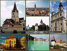


The main tourist attractions in the county are:
- The city of Sibiu with its medieval fortifications and its historic centre.
- The medieval city of Mediaș.
- The medieval Saxon fortified churches and villages from Transylvania, some of them being UNESCO World Heritage Sites:
- Biertan.
- Valea Viilor.
- Cisnădie.
- Cisnădioara.
- Slimnic.
- Agnita.
- The abbey of Cârța
- The Făgăraș Mountains.
- The Bâlea Valley and the Transfăgărășan.
- The Negoiu Peak.
- Păltiniș mountain resort and the Cindrel Mountains.
- Ocna Sibiului, Bazna and Miercurea Sibiului Spa towns.
- The Mărginimea Sibiului rural area.
People[]
Administrative divisions[]

Sibiu County has 2 municipalities, 9 towns and 53 communes
- Municipalities
- Towns
- Communes
- Alma
- Alțâna
- Apoldu de Jos
- Arpașu de Jos
- Ațel
- Axente Sever
- Bazna
- Bârghiș
- Biertan
- Blăjel
- Boița
- Brateiu
- Brădeni
- Bruiu
- Chirpăr
- Cârța
- Cârțișoara
- Cristian
- Dârlos
- Gura Râului
- Hoghilag
- Iacobeni
- Jina
- Laslea
- Loamneș
- Ludoș
- Marpod
- Merghindeal
- Micăsasa
- Mihăileni
- Moșna
- Nocrich
- Orlat
- Păuca
- Poiana Sibiului
- Poplaca
- Porumbacu de Jos
- Racovița
- Rășinari
- Râu Sadului
- Roșia
- Sadu
- Slimnic
- Șeica Mare
- Șeica Mică
- Șelimbăr
- Șura Mare
- Șura Mică
- Tilișca
- Târnava
- Turnu Roșu
- Valea Viilor
- Vurpăr
Historical county[]
Județul Sibiu | |
|---|---|
County (Județ) | |
 Panoramic view of Sibiu in 1928. | |
 Coat of arms | |
 | |
| Country | |
| Historic region | Transylvania and Crişana |
| Capital city (Reședință de județ) | Sibiu |
| Established | 1925 |
| Area | |
| • Total | 3,531 km2 (1,363 sq mi) |
| Population (1930) | |
| • Total | 194,619 |
| • Density | 55/km2 (140/sq mi) |
| Time zone | UTC+2 (EET) |
| • Summer (DST) | UTC+3 (EEST) |
Historically, the county was located in the central part of Greater Romania, in the southern part of the historical region of Transylvania. The capital was Sibiu.
The interwar county's territory included most of the southwestern portion of today's Sibiu County, excluding the area around Vizocna that belonged to former Hungarian subdivision of Alsó-Fehér County, and the communes of Agârbiciu, Buia, Frâua, Hașag, Șelca Mare, and Șelca Mică, which all belonged to Târnava Mare County. Sibiu County once contained the district around Sebeș, which passed in 1925 to Alba County.
It was bordered to the west by the counties of Hunedoara and Alba, to the north by the counties of Târnava-Mică and Târnava Mare, to the east by Făgăraș County, and to the south by the counties of Gorj and Vâlcea.
Administration[]

The county originally consisted of the city of Sibiu and four districts (plăṣi):[5]
- Plasa Mercurea, headquartered at Mercurea
- Plasa Ocna Sibiului, headquartered at Ocna Sibiului
- Plasa Săliște, headquartered at Săliște
- Plasa Sibiu, headquartered at Sibiu
A subsequent administrative division in 1937 had the county divided into the city of Sibiu and six districts:
- Plasa Avrig, headquartered at Avrig
- Plasa Mercurea, headquartered at Mercurea
- Plasa Nocrich, headquartered at Nocrich
- Plasa Ocna Sibiului, headquartered at Ocna Sibiului
- Plasa Săliște, headquartered at Săliște
- Plasa Sibiu, headquartered at Sibiu
Population[]
According to the census data of 1930, the county's population was 194,619, of which 62.0% were Romanians, 29.3% Germans, 4.7% Hungarians, as well as other minorities.[6] In the religious aspect, the population consisted of 52.0% Eastern Orthodox, 27.8% Lutheran, 12.7% Greek Catholic, 4.0% Roman Catholic, 2.2% Reformed (Calvinist), as well as other minorities.[7]
Urban population[]
In 1930, the urban population was ethnically divided as follows: 43.8% Germans, 37.7% Romanians, 13.2% Hungarians, 2.7% Jews, as well as other minorities. As a mother tongue in the urban population, German was spoken by 44.7% of the population, followed by Romanian (38.5%), Hungarian (13.7%), Yiddish (1.4%), as well as other minority languages. From the religious point of view, the urban population was made up of 38.8% Lutheran, 31.5% Eastern Orthodox, 12.9% Roman Catholic, 7.5% Greek Catholic, 5.2% Reformed, 2.9% Jewish, as well as other minorities.
References[]
| Wikimedia Commons has media related to Sibiu County. |
- ^ The number used depends on the numbering system employed by the phone companies on the market.
- ^ National Institute of Statistics, "Populația după etnie" Archived 2009-08-16 at the Wayback Machine
- ^ National Institute of Statistics, "Populația la recensămintele din anii 1948, 1956, 1966, 1977, 1992 și 2002"
- ^ "Rezultatele finale ale alegerilor locale din 2020" (Json) (in Romanian). Autoritatea Electorală Permanentă. Retrieved 2020-11-02.
- ^ Portretul României Interbelice - Județul Sibiu
- ^ Recensământul general al populației României din 29 decemvrie 1930, Vol. II, pag. 410-413
- ^ Recensământul general al populației României din 29 decemvrie 1930, Vol. II, pag. 726-727
External links[]

| show Authority control |
|---|
- Sibiu County
- Counties of Romania
- Geography of Transylvania
- 1925 establishments in Romania
- 1938 disestablishments in Romania
- 1945 establishments in Romania
- 1950 disestablishments in Romania
- 1968 establishments in Romania
- States and territories established in 1925
- States and territories disestablished in 1938
- States and territories established in 1945
- States and territories disestablished in 1950
- States and territories established in 1968