Balangiga
Balangiga | |
|---|---|
| Municipality of Balangiga | |
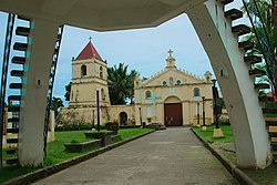 Balangiga Church | |
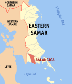 Map of Eastern Samar with Balangiga highlighted | |
show OpenStreetMap | |
 Balangiga Location within the Philippines | |
| Coordinates: 11°06′35″N 125°23′15″E / 11.10972°N 125.3875°ECoordinates: 11°06′35″N 125°23′15″E / 11.10972°N 125.3875°E | |
| Country | |
| Region | Eastern Visayas |
| Province | Eastern Samar |
| District | Lone district |
| Barangays | 13 (see Barangays) |
| Government | |
| • Type | Sangguniang Bayan |
| • Mayor | Randy D. Graza |
| • Vice Mayor | Samuel A. Enciso |
| • Representative | Maria Fe R. Abunda |
| • Councilors | show
List |
| • Electorate | 10,501 voters (2019) |
| Area | |
| • Total | 190.05 km2 (73.38 sq mi) |
| Elevation | 31 m (102 ft) |
| Highest elevation | 281 m (922 ft) |
| Lowest elevation | 0 m (0 ft) |
| Population (2020 census) [3] | |
| • Total | 14,341 |
| • Density | 75/km2 (200/sq mi) |
| • Households | 3,276 |
| Economy | |
| • Income class | 4th municipal income class |
| • Poverty incidence | 39.65% (2015)[4] |
| • Revenue | ₱70,096,358.23 (2016) |
| Service provider | |
| • Electricity | Eastern Samar Electric Cooperative (ESAMELCO) |
| Time zone | UTC+8 (PST) |
| ZIP code | 6812 |
| PSGC | |
| IDD : area code | +63 (0)55 |
| Climate type | tropical rainforest climate |
| Native languages | Waray Tagalog |
| Website | www |


Balangiga (IPA: [ˌbalaŋˈhɪga]), officially the Municipality of Balangiga (Waray: Bungto han Balangiga; Tagalog: Bayan ng Balangiga), is a 4th class municipality in the province of Eastern Samar, Philippines. According to the 2020 census, it has a population of 14,341 people. [3]
Balangiga is the site of the Balangiga Encounter in 1901, which remains one of the longest-running and most controversial issues of the Philippine–American War.
History[]
Balangiga Encounter and Bells[]
During the Philippine-American War, on September 28, 1901, Eugenio Daza, Area Commander of Southeastern Samar and Valeriano Abanador, the Balangiga's police chief, launched an attack on U.S. Army Company C 9th Infantry Regiment who were occupying Balangiga. With Philippine Revolutionary Army forces and Balangiga villagers, killing 48 and wounding 22 of the 78 men of the unit, with only four escaping unhurt and four missing in action. The villagers captured about 100 rifles and 25,000 rounds of ammunition. An estimated 20 to 25 of them died in the fighting, with a similar number of wounded.[5]


In reprisal, General Jacob H. Smith ordered that Samar be turned into a "howling wilderness" and that they shoot any Filipino male above ten years of age[5] who was capable of bearing arms. The American soldiers seized three church bells from the town church and moved them back to the United States as war trophies. The 9th Infantry Regiment maintained that the single bell in their possession was presented to the regiment by villagers when the unit left Balangiga on 9 April 1902. The bell had been actually given to them by the 11th Infantry Regiment, which had taken all three bells when they left Balangiga for Tacloban on 18 October 1901.[7]
Smith and his primary subordinate, Major Littleton Waller of the United States Marine Corps, were both court-martialled for illegal vengeance against the civilian population of Samar. Waller was acquitted of the charges. Smith was found guilty, admonished and retired from service, but charges were dropped shortly after. He was later hailed as a war hero.[8]
The bells were returned on December 11, 2018.[9]
Geography[]

Balangiga is located on the southern coast of the island of Samar facing Leyte Gulf, and sits at the mouth of the Balangiga River. To the west lies the municipality of Lawaan, to the north is Llorente, and to the east are the municipalities of Quinapondan and Giporlos.
Barangays[]
Balangiga is politically subdivided into 13 barangays. [10]
- Bacjao
- Cag-olango
- Cansumangcay
- Guinmaayohan
- Poblacion I
- Poblacion II
- Poblacion III
- Poblacion IV
- Poblacion V
- Poblacion VI
- San Miguel
- Santa Rosa
- Maybunga
Climate[]
| hideClimate data for Balangiga, Eastern Samar | |||||||||||||
|---|---|---|---|---|---|---|---|---|---|---|---|---|---|
| Month | Jan | Feb | Mar | Apr | May | Jun | Jul | Aug | Sep | Oct | Nov | Dec | Year |
| Average high °C (°F) | 28 (82) |
28 (82) |
29 (84) |
30 (86) |
30 (86) |
30 (86) |
29 (84) |
30 (86) |
30 (86) |
29 (84) |
29 (84) |
28 (82) |
29 (84) |
| Average low °C (°F) | 22 (72) |
22 (72) |
22 (72) |
23 (73) |
24 (75) |
24 (75) |
24 (75) |
24 (75) |
24 (75) |
24 (75) |
23 (73) |
23 (73) |
23 (74) |
| Average precipitation mm (inches) | 90 (3.5) |
67 (2.6) |
82 (3.2) |
70 (2.8) |
97 (3.8) |
145 (5.7) |
152 (6.0) |
127 (5.0) |
132 (5.2) |
152 (6.0) |
169 (6.7) |
144 (5.7) |
1,427 (56.2) |
| Average rainy days | 17.0 | 13.5 | 16.0 | 16.5 | 20.6 | 24.3 | 26.0 | 25.4 | 25.2 | 26.4 | 23.0 | 21.1 | 255 |
| Source: Meteoblue [11] | |||||||||||||
Demographics[]
| Year | Pop. | ±% p.a. |
|---|---|---|
| 1903 | 4,914 | — |
| 1918 | 10,125 | +4.94% |
| 1939 | 19,858 | +3.26% |
| 1948 | 21,621 | +0.95% |
| 1960 | 8,215 | −7.75% |
| 1970 | 9,538 | +1.50% |
| 1975 | 8,474 | −2.34% |
| 1980 | 9,559 | +2.44% |
| 1990 | 9,565 | +0.01% |
| 1995 | 11,100 | +2.83% |
| 2000 | 10,662 | −0.86% |
| 2007 | 12,428 | +2.14% |
| 2010 | 12,756 | +0.95% |
| 2015 | 14,085 | +1.91% |
| 2020 | 14,341 | +0.35% |
| Source: Philippine Statistics Authority [12] [13] [14][15] | ||
In the 2020 census, the population of Balangiga, Eastern Samar, was 14,341 people, [3] with a density of 75 inhabitants per square kilometre or 190 inhabitants per square mile.
Economy[]
| Poverty Incidence of Balangiga | |
| Source: Philippine Statistics Authority[16][17][18][19][20][21] | |
Transportation[]
Balangiga can be reached through public utility vans and buses from Tacloban City. Pedicabs (potpot), tricycles, and habal-habal by the means of inner town transportation.
Education[]
Balangiga has 9 public elementary schools, namely:
- Balangiga Central Elementary School
- Bacjao Elementary School
- Bangon Elementary School
- Cag-olango Elementary School
- Cansumangkay Elementary School
- Guinmaayohan Elementary School
- Maybunga Elementary School
- San Miguel Elementary School
- Santa Rosa Elementary School
Has 1 public secondary school:
- Southern Samar National Comprehensive High School
Has 1 private secondary school:
- MSH Sisters Academy Balangiga
Daughter Towns[]
The municipalities of Lawaan, Giporlos, and Quinapondan were former barangays of the municipality of Balangiga.
See also[]
References[]
- ^ Municipality of Balangiga | (DILG)
- ^ "2015 Census of Population, Report No. 3 – Population, Land Area, and Population Density" (PDF). Philippine Statistics Authority. Quezon City, Philippines. August 2016. ISSN 0117-1453. Archived (PDF) from the original on May 25, 2021. Retrieved July 16, 2021.
- ^ Jump up to: a b c Census of Population (2020). "Region VIII (Eastern Visayas)". Total Population by Province, City, Municipality and Barangay. PSA. Retrieved 8 July 2021.
- ^ https://psa.gov.ph/sites/default/files/City%20and%20Municipal-level%20Small%20Area%20Poverty%20Estimates_%202009%2C%202012%20and%202015_0.xlsx; publication date: 10 July 2019; publisher: Philippine Statistics Authority.
- ^ Jump up to: a b Bautista, Veltisezar. "The Balangiga, Samar, Massacre". Archived from the original on 26 February 2008. Retrieved 20 March 2008.
- ^ Dobson, G. B. "Fort D. A. Russell Photos". Retrieved 16 December 2018.
- ^ Robson, Seth (7 July 2004). "Book casts doubt on bell's history". Stars and Stripes. Retrieved 21 March 2008.
- ^ "Philippine Insurrection, 1899-1902: A Working Bibliography". Ibiblio.org. Retrieved 20 March 2008.
- ^ "US returns looted Balangiga church bells to Philippines". BBC. 15 December 2018.
- ^ "Province: Eastern Samar". PSGC Interactive. Quezon City, Philippines: Philippine Statistics Authority. Retrieved 12 November 2016.
- ^ "Balangiga, Eastern Samar : Average Temperatures and Rainfall". Meteoblue. Retrieved 30 December 2018.
- ^ Census of Population (2015). "Region VIII (Eastern Visayas)". Total Population by Province, City, Municipality and Barangay. PSA. Retrieved 20 June 2016.
- ^ Census of Population and Housing (2010). "Region VIII (Eastern Visayas)". Total Population by Province, City, Municipality and Barangay. NSO. Retrieved 29 June 2016.
- ^ Censuses of Population (1903–2007). "Region VIII (Eastern Visayas)". Table 1. Population Enumerated in Various Censuses by Province/Highly Urbanized City: 1903 to 2007. NSO.
- ^ "Province of Eastern Samar". Municipality Population Data. Local Water Utilities Administration Research Division. Retrieved 17 December 2016.
- ^ "Poverty incidence (PI):". Philippine Statistics Authority. Retrieved 28 December 2020.
- ^ https://psa.gov.ph/sites/default/files/NSCB_LocalPovertyPhilippines_0.pdf; publication date: 29 November 2005; publisher: Philippine Statistics Authority.
- ^ https://psa.gov.ph/sites/default/files/2003%20SAE%20of%20poverty%20%28Full%20Report%29_1.pdf; publication date: 23 March 2009; publisher: Philippine Statistics Authority.
- ^ https://psa.gov.ph/sites/default/files/2006%20and%202009%20City%20and%20Municipal%20Level%20Poverty%20Estimates_0_1.pdf; publication date: 3 August 2012; publisher: Philippine Statistics Authority.
- ^ https://psa.gov.ph/sites/default/files/2012%20Municipal%20and%20City%20Level%20Poverty%20Estima7tes%20Publication%20%281%29.pdf; publication date: 31 May 2016; publisher: Philippine Statistics Authority.
- ^ https://psa.gov.ph/sites/default/files/City%20and%20Municipal-level%20Small%20Area%20Poverty%20Estimates_%202009%2C%202012%20and%202015_0.xlsx; publication date: 10 July 2019; publisher: Philippine Statistics Authority.
External links[]
| Wikimedia Commons has media related to Balangiga. |
- Balangiga Profile at PhilAtlas.com
- Philippine Standard Geographic Code
- Philippine Census Information
- Local Governance Performance Management System
| show Places adjacent to Balangiga |
|---|
| show |
|---|
| show Authority control |
|---|
- Municipalities of Eastern Samar