Bamyan
Bamyan
بامیان Bamiyan | |
|---|---|
City | |
       | |
| Motto(s): بامیان بام دنیا "Bamyan, roof of the world" | |
 Bamyan Location in Afghanistan | |
| Coordinates: 34°49′30″N 67°50′00″E / 34.82500°N 67.83333°ECoordinates: 34°49′30″N 67°50′00″E / 34.82500°N 67.83333°E | |
| Country | |
| Province | Bamyan |
| Settled | 2800 BCE[citation needed] |
| Government | |
| • President of City Council | |
| Area | |
| • Total | 35 km2 (14 sq mi) |
| Elevation | 2,550 m (8,370 ft) |
| Population (2014) | |
| • Total | 100,000 |
| Time zone | UTC+4:30 |
| Control | |

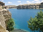
Bamyan (/ˌbæmiˈɑːn, ˌbɑː-/;[1][2] Pashto/Dari: بامیان) also spelled Bamiyan[3] or Bamian[4] is the capital of Bamyan Province in central Afghanistan. With an altitude of about 2,550 m and a population of about 100,000 (in 2014), Bamyan is the largest town in the central Afghanistan region of Hazarajat, and lies approximately 240 kilometres north-west of Kabul, the national capital. It also refers to the surrounding valley. Many statues of Buddha are carved into the sides of cliffs facing Bamyan city. In 2008, Bamyan was found to be the home of the world's oldest oil paintings.[5] The city of Bamyan has four districts and a total land area of 3,539 hectares.[6] The total number of dwellings in this city are 4,435.[6]
The valley is the Center of the Hazara settlement area, now known as Hazarajat. At the end of the 10th century AD, there was a Buddhist culture in which several thousand Buddhist monks lived in caves carved into the mountain. The 53 and 35 meters high standing Buddha statues are two of the best known monuments left from the Buddhists, which were then destroyed by the Taliban in 2001. Furthermore, there are several cultural sites left from both the Buddhist and from the later Islamic era of the valley. After the overthrown of Taliban from power in 2002, considerable efforts have been made to preserve the cultural monuments in the valley.
The Bamiyan valley marked the most westerly point of Buddhist expansion and was a crucial hub of trade for much of the second millennium CE. It was a place where East met West and its archaeology reveals a blend of Greek, Turkic, Persian, Chinese and Indian influence. The valley is one of Afghanistan's most touristic places.[7]
The city of Bamyan joined the UNESCO Creative Cities Network as a Crafts and Folk Art city in 2017.[8]
On 15 August 2021, Bamiyan was seized by Taliban fighters, becoming the twenty-ninth provincial capital to be captured by the Taliban as part of the wider 2021 Taliban offensive.
Name[]
The name of "Bamiyan" is derived from Middle Persian Bamikan.[9]
Geography[]


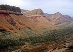
The 2,500 m high valley is about 230 km northwest of Kabul and separates the Hindu Kush mountain range from the Koh-e Baba mountains. On the north side there is an approximately 1.5 kilometres long, high, almost vertical sandstone cliff that was formed by a glacier. The Buddha statues and most of the caves in the valley were carved into this rock face. In the valley itself and on the slopes, there are numerous ruins from earlier times.
Situated on the ancient Silk Route, the town was at the crossroads between the East and West when all trade between China and the Middle East passed through it. The Hunas made it their capital in the 5th century. Because of the cliff of the Buddhas, the ruins of the Monk's caves, Shahr-e Gholghola ('City of Sighs', the ruins of an ancient city destroyed by Genghis Khan during the 1221 siege of Bamiyan), and its local scenery, it is one of the most visited places in Afghanistan. The Shahr-e Zuhak mound ten miles south of the valley is the site of a citadel that guarded the city, and the ruins of an acropolis could be found there as recently as the 1990s.[10]

The town is the cultural center of the Hazara ethnic group of Afghanistan. Most of the population lives in downtown Bamyan. The valley is cradled between the parallel mountain ranges of the Hindu Kush and the Koh-i-Baba.
Mountains cover ninety percent of the province, and the cold, long winter, lasting for six months, brings temperatures of three to twenty degrees Celsius below zero. Mainly Daizangi Hazara people live in the area. Transportation facilities are increasing, but sparse. Notably Bamyan is now connected by road to Kabul through Parwan province and through Maidan Wardak. The connection between Maidan Shar and Bamyan – 136 km long – makes it possible to reach Kabul in a 2-hour drive. The connection is almost completed missing just 15 km of paving
The main crops are wheat, barley, mushung, and baquli, grown in spring. When crops are damaged by unusually harsh weather, residents herd their livestock down to Ghazni and Maidan provinces to exchange for food.
The city and the province are served by Bamyan Airport. A new airport has been completed in 2015 with an asphalt runway. The project was funded by the Japanese Government and carried out by the United Nations Office for Project Services (UNOPS).
Climate[]
Bamyan's climate is transitional between cold arid (Köppen BWk) and semi-arid (Köppen BSk), with cold winters and warm, dry summers. Precipitation mostly falls in late winter and spring.
| hideClimate data for Bamyan | |||||||||||||
|---|---|---|---|---|---|---|---|---|---|---|---|---|---|
| Month | Jan | Feb | Mar | Apr | May | Jun | Jul | Aug | Sep | Oct | Nov | Dec | Year |
| Record high °C (°F) | 12.0 (53.6) |
12.5 (54.5) |
20.6 (69.1) |
28.7 (83.7) |
29.4 (84.9) |
31.2 (88.2) |
33.2 (91.8) |
32.2 (90.0) |
31.4 (88.5) |
26.2 (79.2) |
20.6 (69.1) |
13.0 (55.4) |
33.2 (91.8) |
| Average high °C (°F) | 1.0 (33.8) |
2.0 (35.6) |
7.9 (46.2) |
15.6 (60.1) |
19.9 (67.8) |
24.1 (75.4) |
26.3 (79.3) |
26.1 (79.0) |
22.9 (73.2) |
17.4 (63.3) |
11.0 (51.8) |
5.1 (41.2) |
14.9 (58.9) |
| Daily mean °C (°F) | −6.4 (20.5) |
−4.8 (23.4) |
1.4 (34.5) |
8.6 (47.5) |
12.4 (54.3) |
16.3 (61.3) |
18.4 (65.1) |
17.4 (63.3) |
12.8 (55.0) |
7.8 (46.0) |
1.6 (34.9) |
−2.8 (27.0) |
6.9 (44.4) |
| Average low °C (°F) | −10.1 (13.8) |
−6.1 (21.0) |
−3.8 (25.2) |
2.9 (37.2) |
5.7 (42.3) |
8.5 (47.3) |
10.0 (50.0) |
8.8 (47.8) |
4.2 (39.6) |
0.0 (32.0) |
−4.9 (23.2) |
−8.6 (16.5) |
0.5 (33.0) |
| Record low °C (°F) | −30.5 (−22.9) |
−28.4 (−19.1) |
−21.2 (−6.2) |
−6.5 (20.3) |
−2.5 (27.5) |
0.6 (33.1) |
5.4 (41.7) |
3.0 (37.4) |
−2.6 (27.3) |
−7.9 (17.8) |
−14.5 (5.9) |
−25 (−13) |
−30.5 (−22.9) |
| Average precipitation mm (inches) | 8.3 (0.33) |
15.7 (0.62) |
27.4 (1.08) |
29.8 (1.17) |
26.0 (1.02) |
5.7 (0.22) |
1.0 (0.04) |
0.0 (0.0) |
3.1 (0.12) |
4.2 (0.17) |
7.5 (0.30) |
4.3 (0.17) |
133 (5.24) |
| Average rainy days | 0 | 0 | 2 | 7 | 6 | 1 | 1 | 0 | 0 | 2 | 2 | 0 | 21 |
| Average snowy days | 5 | 7 | 6 | 2 | 0 | 0 | 0 | 0 | 0 | 0 | 1 | 3 | 24 |
| Average relative humidity (%) | 43 | 54 | 52 | 52 | 52 | 46 | 45 | 45 | 43 | 44 | 48 | 52 | 48 |
| Mean monthly sunshine hours | 196.7 | 174.6 | 210.7 | 239.4 | — | 356.9 | 372.9 | 357.8 | 325.3 | 276.7 | 245.5 | 198.0 | — |
| Source 1: Hong Kong Observatory[11] | |||||||||||||
| Source 2: NOAA (1960–1983)[12] | |||||||||||||
History[]


| History of Afghanistan |
|---|
 |
| Timeline |
| Related historical names of the region |
| Related topics |
|
The city of Bamyan was part of the Kushan Empire in the early centuries of the Christian era. After the Kushan Empire fell to the Sassanids, Bamyan became part of the Kushansha, vassals to the Sassanids. The Buddhist pilgrim Fa Xian visited Bamyan in the fifth century and recorded that the king summoned the monks of the region for vows and prayers. Fa Xian also records landslides and avalanches in the mountains and the presence of snow during winter and summer. This latter statement suggests climatic change which could have contributed to the historical and economic importance of the area for the years to come. Another Buddhist traveller, Xuanzang, passed through Bamyan in the seventh century. His record shows that the Bamiyan Buddhas and cave monastery near it were already built. He also records that Buddhism in the region was in decay with the people being "hard and uncultivated".[13]
The Hephthalites conquered Bamyan in the 5th century. After their Khanate was destroyed by the Sassanids and Turks in 565, Bamyan became the capital of the small Kushano-Hephthalite kingdom until 870, when it was conquered by the Saffarids. The area was conquered by the Ghaznavids in the 11th century. The Ghurid Dynasty then ruled over Bamyan during the late 12th century.[13] In 1221 the city and its population were completely wiped out by Genghis Khan. The Qarlughids established their capital in the city soon thereafter. There is some evidence that Bamyan was somewhat populated and reconstructed during the Timurid period in the 15th century. In 1840, the region was under conflict because of the First Anglo-Afghan War when the British routed Dost Mohammad Khan and his forces.[13] The first European to see Bamyan was William Moorcroft (explorer) about 1824. During 1998–2001, Bamyan has been the center of combat between Taliban forces and the anti-Taliban alliance; mainly Hizb-i-Wahdat – amid clashes among the warlords of local militia. Bamyan is also known as the capital of Daizangi.
Favoured by its location on one of the main trade routes from the West to China and India, the valley was of great strategic importance even in ancient times. In the past it became a stop for trade caravans, a well-known artistic site and was also a major Buddhist center for centuries. Under later Islamic rule, Bamiyan also gained great importance until the valley was destroyed and completely devastated by Genghis Khan.
Several decades passed before a town appeared in the valley again, but it could only acquire regional importance.
Buddhas[]

Ashoka, the ruler of the ancient Indian Maurya dynasty, according to an old inscription, was sent in 261 BC. to convert the area. This was just before the Greco-Bactrian Kingdom declared independence in the northern Hindu Kush region.
Under the rule of the Kushana dynasty, Buddhism gradually established itself in the Hindu Kush area. Between the 2nd and 4th centuries AD, a number of Buddhist sites arose along the trade routes at that. Bamiyan itself was to become the largest and most famous of these Buddhist sites. However, the exact point in time when Buddhism found its way into Bamiyan itself is not known.
This Buddhist art was significantly influenced by the earlier Gandhara culture, which was developed further in the south, and the Indian Gupta culture, was the result of this cultural creation being unique of its kind.[14] The Gandhara culture was already in retreat or largely collapsed when Buddhism experienced a revival here.
The two large Buddha statues were constructed in the large rock facing the north side of the valley in the 6th century. Corridors and galleries were carved into the rock around the figures and hundreds of prayer halls and caves were created, some of which were decorated with rich wall paintings.
The number of caves currently present in Bamiyan is estimated to be around 1,000.[15] The time of origin is dated to the period from 450 to 850 AD. Some of the murals have been identified as the oldest known oil paintings in the world, dated to the 7th century. An earlier chronicle estimates the number at 12,000 caves, a number that is exaggerated for the Bamiyan Valley alone, but seems appropriate for the entire region, including around 50 km of surrounding valleys.
In the late ancient times, the adjoining room was mainly in the hands of tribes who were counted among the Iranian Huns and were in conflict with the Sassanid Empire. After 560, the Gök Turks became the dominant power in Transoxania.
Xuanzang, a Chinese monk, visited the valley around the 630 AD and was welcomed by King Bamiyan. He spent around 15 days in the valley and described the Buddha statues present in the valley, as well as the location of some temples, whereby his information was confirmed by science as very exact. Based on further statements by Xuanzang, it is assumed that at least half of the one thousand caves known today must have been inhabited. Almost a hundred years later, in 727, the Korean monk Hyecho (Hui Chao) described Bamiyan as an independent and powerful kingdom, despite the presence of Muslim Arab troops in the north and south of the region.
On the cliff face of a mountain nearby, three colossal statues were carved 4,000 feet apart. One of them was 175 feet (53 m) high standing statue of Buddha, the world's tallest. The ancient statue was carved during the Kushan period in the fifth century. The statues were destroyed by the Taliban in March 2001, on the grounds that they were an affront to Islam. Limited efforts have been made to rebuild them, with negligible success.
At one time, two thousand monks meditated in caves among the sandstone cliffs.[citation needed] The caves were also a big tourist attraction before the long series of wars in Afghanistan. The world's earliest oil paintings have been discovered in caves behind the destroyed statues. Scientists from the European Synchrotron Radiation Facility have confirmed that the oil paintings, probably of either walnut or poppy seed oil, are present in 12 of the 50 caves dating from the 5th to 9th century.[16] The murals typically have a white base layer of a lead compound, followed by an upper layer of natural or artificial pigments mixed with either resins or walnut or poppy seed drying oils. Possibly, the paintings may be the work of artists who travelled on the Silk Road.[17]
The caves at the base of these statues were used by Taliban for storing weapons. After the Taliban were driven from the region, civilians made their homes in the caves. Recently, Afghan refugees escaped the persecution of the Taliban regime by hiding in caves in the Bamiyan valley. These refugees discovered a fantastic[clarification needed] collection of Buddhist statues as well as jars holding more than ten thousand fragments of ancient Buddhist manuscripts, a large part of which is now in the Schøyen Collection. This has created a sensation among scholars, and the find has been compared with the discovery of the Dead Sea Scrolls.
From 2003 to 2013, a Provincial Reconstruction Team was based in Bamyan, first manned by U.S. forces, and, since April 2003, by New Zealand Defence Force personnel which made up the Provincial Reconstruction Team. The 34th Division in the area, part of the 4th Corps, was affiliated with Karim Khalili.[18] Bamiyan was one of the first pilot centres for the Afghan New Beginnings Programme of Disarmament, demobilization and reintegration. On 4 July 2004 disarmament began in Bamiyan,[19] and on 15 July 2004 disarmament was continuing in Bamiyan including soldiers from the 34th and 35th Divisions of the then Afghan Army, often referred to as the Afghan Military or Militia Forces.[20]
Islamic Domination and Islamization[]
Under the reign of Sultan Mahmud, Bamiyan was Islamized. This was around the time of the first millennium AD. At that time, the center of the city of Bamiyan was moved from the northwest of the valley, where the cliff with the Buddha statues is located, further to the southeast. Some of the fortifications in the valley also date from this period.[21] Under the rule of the Ghurids , Bamiyan was the capital of a large kingdom for about 60 years, namely from 1155 to 1212, which stretched north to the Oxus River (today's Amu Darya).[21]
Destroyed by Genghis Khan[]
A few years later, in 1221, Genghis Khan completely devastated the city and massacred its residents, as he was taking revenge for his slain grandson. Bamiyan was unable to recover from this event for a long time. Even decades later, the city was still devastated, according to a report by a Persian historian.[22]
Resettlement as a regional center[]
From the age of the Timurids, there is said to have been a city again in Bamiyan. However, the general decline in coast-to-coast trade during this time meant that the city could no longer grow to its old size and could no longer achieve supra-regional importance.
Bamiyan is also mentioned again in the history books during the Mughal Empire , especially in connection with Aurangzeb , who had the 53 m tall Buddha statue shot at with cannons during his looting.
During the time of the Afghan monarchy, Bamiyan was a bulwark in the central mountain region. At that time, however, the area was still claimed by the Uzbek Miren ruling in the north. They demanded tribute payments, mainly in the form of deliveries from slaves from the Hazara tribes of the surrounding mountains.
Recent history[]
Before the caves were systematically examined by archaeologists in the 20th century, thousands of nomads used them as living quarters. Around 2,500 civil war refugees also lived in the caves for years.[23]
During the Afghan Civil War, the Bamiyan Valley was a strategically important place that was often contested. At that time, many of the caves were used for years as ammunition depots or weapons stores.
On March 12, 2001, on the orders of Mullah Mohammed Omar, Taliban militias blew up the statues that had been damaged by vandalism in previous years. Eighty percent of the cave paintings were also destroyed or looted during the war.
The Bamiyan Valley has always been the habitat of the Hazara, and the Kuchi nomadic people. In recent years, this previously peaceful harmony has repeatedly led to sometimes violent conflicts due to the scarcity of resources.
Demography[]
The population of this city is estimated to be 100,000 in 2016. Hazaras make up almost the entire population of Bamyan.[24][25]
Land use[]
Bamyan, located in the central highlands, is one of the oldest cities in the country and is widely known for the giant, ancient Buddha statues that were carved into the side of a cliff. The city of Bamyan is dominated by agriculture at 54% with only 18% of total land classified as built-up.[citation needed]
Today's city Bamiyan[]
The city of Bamiyan is the only urban settlement in the entire Bamiyan Province. It became the center of the then newly created Bamiyan Province in 1964. The city grew rapidly, but at the same time suffered from the lack of a zoning plan. Bamiyan's bazaar at that time had around 300 to 400 shops and its market were very busy twice a week.[22]
Historical Sites[]
The numerous remains of monasteries, painted caves, statues and fortifications have been on the UNESCO list of world cultural heritage since 2003. At the same time, they were also entered on the Red List of World Heritage in Danger.
International sister cities[]
See also[]
- Bamyan Province
- Buddha Collapsed out of Shame
- Buddhism in Afghanistan
- Great Tang Records on the Western Regions
- Greco-Buddhism
- Hazarajat
- Hazara people
- Silk Road transmission of Buddhism
Notes[]
- ^ "Bamian". Lexico UK Dictionary. Oxford University Press.
- ^ "Bamian". Merriam-Webster Dictionary.
- ^ e.g. Unesco Archived January 28, 2007, at the Wayback Machine, BBC
- ^ "About this Collection". The Library of Congress. Retrieved 26 April 2016.
- ^ "Top 10 Discoveries of 2008 - Oldest Oil Paintings - Bamiyan, Afghanistan - Archaeology Magazine Archive". archive.archaeology.org. 2009. Retrieved January 29, 2020.
- ^ Jump up to: a b "The State of Afghan Cities report 2015". UN-Habitat. 2015. Archived from the original on 2015-10-31. Retrieved 2015-10-22.
- ^ Rasmussen, Sune Engel (September 19, 2014). "An Afghan Town Known for Its Blown-Up Buddhas Wants to Be Your Next Holiday Destination". Slate Magazine.
- ^ "The Historic City of Bamiyan has joined the UNESCO Global Network of Learning Cities (GNLC) - Afghanistan National Commission for UNESCO". unesconatcom.af. Retrieved 2018-10-03.
- ^ https://iranicaonline.org/articles/bamian-town-in-central-afghanistan#pt2
- ^ Ring, Trudy;Salkin, Robert M.;Schellinger, Paul E; La Boda, Sharon (1995) International Dictionary of Historic Places: Asia and Oceania, P.79. Taylor & Francis, ISBN 1-884964-04-4
- ^ "Climatological Normals of Bamiyan". Hong Kong SAR Government. Retrieved 2011-01-05.
- ^ "Bamiyan Climate Normals 1961–1990". National Oceanic and Atmospheric Administration. Retrieved December 26, 2012.
- ^ Jump up to: a b c Schellinger, Paul; Salkin, Robert, eds. (1996). International Dictionary of Historic Places, Volume 5: Asia and Oceania. Chicago: Fitzroy Dearborn Publishers. pp. 80, 81. ISBN 1-884964-04-4.
- ^ Foundation, Encyclopaedia Iranica. "Welcome to Encyclopaedia Iranica". iranicaonline.org. Retrieved 2021-08-01.
- ^ "The Impact of War upon Afghanistan's Cultural Heritage" (PDF).
- ^ Marine Cotte, J. Anal. At. Spectrom., 2008, 23, doi:10.1039/b801358f
- ^ European Synchrotron Radiation Facility, "Synchrotron light unveils oil in ancient Buddhist paintings from Bamiyan", March 24, 2011
- ^ Michael Vinay Bhatia, Mark Sedra, Afghanistan, Arms and Conflict: Post-9/11 Security and Insurgency, Routledge, 2008, ISBN 113405422X, 283.
- ^ "Press Briefing by Manoel de Almeida e Silva, Spokesman for the Special Representative of the Secretary-General on Afghanistan". UN News Centre. 4 July 2004. Retrieved 26 April 2016.
- ^ "Press Briefing by David Singh Senior Media Relations Officer and by UN agencies in Afghanistan". UN News Centre. 15 July 2004. Retrieved 26 April 2016.
- ^ Jump up to: a b Foundation, Encyclopaedia Iranica. "Welcome to Encyclopaedia Iranica". iranicaonline.org. Retrieved 2021-08-11.
- ^ Jump up to: a b Foundation, Encyclopaedia Iranica. "Welcome to Encyclopaedia Iranica". iranicaonline.org. Retrieved 2021-08-14.
- ^ "Wayback Machine" (PDF). web.archive.org. 2014-07-14. Retrieved 2021-08-14. Cite uses generic title (help)
- ^ "The State of Afghan Cities report 2015". Archived from the original on 2015-10-31.
- ^ "Bamyan Province" (pdf). Retrieved 8 July 2013.
- ^ "Cities in Afghanistan and Nebraska forge "sister cities" partnership - Afghanistan". ReliefWeb.
- ^ "International partnerships and sister cities". poriruacity.govt.nz. Retrieved 2018-05-15.
References[]
- Dupree, Nancy Hatch (1977) [1st Edition: 1970]. An Historical Guide to Afghanistan (2nd Edition, Revised and Enlarged ed.). Afghan Tourist Organization.
External links[]
| Wikivoyage has a travel guide for Bamiyan. |
| Wikisource has the text of the 1911 Encyclopædia Britannica article Bamian. |
- Bamyan Tourism – Official Website
- Preparations for the great skiing competition in Bamiyan (video Feb. 26, 2019)
- Bamyan's interesting hotels in the Bamyan TV special report (video Nov. 22, 2018)

| show Authority control |
|---|
- Populated places in Bamyan Province
- Populated places along the Silk Road
- Buddhism in Afghanistan
- Hazarajat
- Hazara people
- Provincial capitals in Afghanistan
- Cities in Afghanistan