Barkmere
Barkmere | |
|---|---|
City | |
 | |
 Coat of arms | |
 Location within Les Laurentides RCM. | |
 Barkmere Location in central Quebec. | |
| Coordinates: 46°00′N 74°35′W / 46.000°N 74.583°WCoordinates: 46°00′N 74°35′W / 46.000°N 74.583°W[1] | |
| Country | |
| Province | |
| Region | Laurentides |
| RCM | Les Laurentides |
| Constituted | March 24, 1926 |
| Government | |
| • Mayor | Luc Trépanier |
| • Federal riding | Laurentides—Labelle |
| • Prov. riding | Argenteuil |
| Area | |
| • Total | 23.70 km2 (9.15 sq mi) |
| • Land | 17.72 km2 (6.84 sq mi) |
| Population (2021)[3] | |
| • Total | 81 |
| • Density | 4.6/km2 (12/sq mi) |
| • Pop 2016-2021 | |
| • Dwellings | 230 |
| Time zone | UTC−5 (EST) |
| • Summer (DST) | UTC−4 (EDT) |
| Postal code(s) | J0T 1A0 |
| Area code(s) | 819 |
| Highways | No major routes |
| Website | www |

Barkmere is a ville in the Canadian province of Quebec, located in Les Laurentides Regional County Municipality.
It is one of the smallest incorporated municipalities in Quebec, with a population of just 81 in the Canada 2021 Census.
Demographics[]
Population trend:[4]
- Population in 2021: 81 (2016 to 2021 population change: 39.7%)
- Population in 2016: 58
- Population in 2011: 58
- Population in 2006: 87
- Population in 2001: 44
- Population in 1996: 53
- Population in 1991: 62
Private dwellings occupied by usual residents: 50 (total dwellings: 230)
Mother tongue:
- English as first language: 18%
- French as first language: 82%
- English and French as first language: 0%
- Other as first language: 0%
Gallery[]

New Town hall and community center built in 2016.
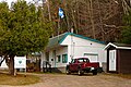
Municipal office

View of the lake

Jesuit island


Education[]
This section needs expansion. You can help by . (September 2017) |
Sir Wilfrid Laurier School Board operates English-language schools:
- Arundel Elementary School in Arundel[5]
- Sainte Agathe Academy (for high school only) in Sainte-Agathe-des-Monts[6]
References[]
- ^ Reference number 3517 of the Commission de toponymie du Québec (in French)
- ^ a b Geographic code 78050 in the official Répertoire des municipalités (in French)
- ^ a b https://www12.statcan.gc.ca/census-recensement/2021/dp-pd/prof/details/page.cfm?Lang=E&SearchText=Barkmere&GENDERlist=1&STATISTIClist=1&DGUIDlist=2021A00052478050
- ^ Statistics Canada: 1996, 2001, 2006, 2011, 2016, 2021 census
- ^ "Arundel Elementary Zone." Sir Wilfrid Laurier School Board. Retrieved on September 16, 2017.
- ^ "SAINTE AGATHE HIGH SCOOL ZONE" [sic]. Sir Wilfrid Laurier School Board. Retrieved on September 17, 2017 - See text description of boundaries in: About Us" as well as the Elementary zone map - Note that all areas covered in the elementary map are also covered in the secondary one.
External links[]
 Media related to Barkmere at Wikimedia Commons
- Ville de Barkmere
| Cities/towns | |
|---|---|
| Municipalities | |
| Townships | |
| Parishes | |
| Villages | |
| |
| Authority control |
|
|---|
This Quebec location article is a stub. You can help Wikipedia by . |
Categories:
- Cities and towns in Quebec
- Incorporated places in Laurentides
- Quebec geography stubs