Barycz (river)
| Barycz | |
|---|---|
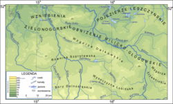 Barycz River on a map of the Silesian-Lusatian Lowlands | |
| Location | |
| Country | Poland |
| Physical characteristics | |
| Source | |
| • location | near Ostrów Wielkopolski |
| Mouth | |
• location | Oder at Wyszanów |
• coordinates | 51°41′11″N 16°15′9″E / 51.68639°N 16.25250°ECoordinates: 51°41′11″N 16°15′9″E / 51.68639°N 16.25250°E |
• elevation | 75.8 metres (249 ft) |
| Length | 136 km (85 mi) |
| Basin size | 5,547 km2 (2,142 sq mi) |
| Discharge | |
| • average | 18.8 m3/s (660 cu ft/s) |
| Basin features | |
| Progression | Oder→ Baltic Sea |

The Barycz (Polish pronunciation: [ˈbarɨtʂ]; German: Bartsch) is a river in Greater Poland and Lower Silesian Voivodeships in western Poland. It is a right tributary of the Odra River. The river course roughly marked the northern border of the historic region of Lower Silesia with Greater Poland.
The Barycz has a length of 136 km and a basin area of 5,547 km².[1] The surrounding terrain of the Barycz Valley Landscape Park is an important wetland reserve. Settlements on the Barycz include Odolanów, Milicz, Sułów, Żmigród, and Wąsosz. The Orla is among its tributaries.
See also[]
- Rivers of Poland
References[]
- ^ Statistical Yearbook of the Republic of Poland 2017, Statistics Poland, p. 85-86
External links[]
| show Tributaries of the Oder / Odra |
|---|

| show Authority control |
|---|
Categories:
- Tributaries of the Oder
- Rivers of Greater Poland Voivodeship
- Rivers of Lower Silesian Voivodeship
- Rivers of Poland