Bascom, Ohio
Bascom, Ohio | |
|---|---|
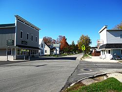 Running concurrently with Ohio State Route 18, Tiffin Street bisects Bascom. | |
| Nickname(s): Crown jewel of Ohio | |
 Location of Bascom | |
| Coordinates: 41°07′58″N 83°17′07″W / 41.13278°N 83.28528°W | |
| Country | United States |
| State | Ohio |
| County | Seneca |
| Elevation | 774 ft (236 m) |
| Time zone | UTC-5 (Eastern (EST)) |
| • Summer (DST) | UTC-4 (EDT) |
| ZIP code | 44809 |
| Area code(s) | 419 |
| GNIS feature ID | 1048488[1] |

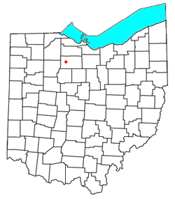
Bascom is a census-designated place in western Hopewell Township, Seneca County, Ohio, United States.[2] It has a post office with the ZIP code 44809, as well as hosts Hopewell-Loudon Elementary and High School.[3] The community is located at the intersection of State Routes 18 and 635 east of Fostoria.
History[]
Bascom was laid out in 1837.[4] The community derives its name from Scott & Bascom, Ohio newspaper editors.[5] A post office called Bascom has been in operation since 1850.[6]
References[]
- ^ Jump up to: a b "US Board on Geographic Names". United States Geological Survey. 2007-10-25. Retrieved 2008-01-31.
- ^ U.S. Geological Survey Geographic Names Information System: Bascom, Ohio
- ^ USPS – Cities by ZIP Code Archived June 15, 2011, at the Wayback Machine
- ^ Lang, William (1880). History of Seneca County, from the Close of the Revolutionary War to July, 1880. Transcript Printing Company. pp. 540.
- ^ Baughman, Abraham J. (1911). History of Seneca County, Ohio: A Narrative Account of Its Historical Progress, Its People, and Its Principal Interests. Lewis Publishing Company. p. 437.
- ^ "Seneca County". Jim Forte Postal History. Archived from the original on 5 January 2016. Retrieved 27 December 2015.
External links[]
| show Municipalities and communities of Seneca County, Ohio, United States |
|---|

Coordinates: 41°07′58″N 83°17′07″W / 41.13278°N 83.28528°W
| show Authority control |
|---|
This Seneca County, Ohio state location article is a stub. You can help Wikipedia by . |
Categories:
- Census-designated places in Ohio
- Census-designated places in Seneca County, Ohio
- Northwest Ohio geography stubs