Bastrop County, Texas
Bastrop County | |
|---|---|
U.S. county | |
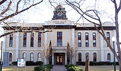 The Bastrop County Courthouse in Bastrop is designed in classical revival style. Built in 1883, the Courthouse and Jail Complex were listed in the National Register of Historic Places on November 20, 1975. | |
 Location within the U.S. state of Texas | |
 Texas's location within the U.S. | |
| Coordinates: 30°06′N 97°19′W / 30.1°N 97.31°W | |
| Country | |
| State | |
| Founded | 1837 |
| Named for | Felipe Enrique Neri, Baron de Bastrop |
| Seat | Bastrop |
| Largest city | Elgin |
| Area | |
| • Total | 896 sq mi (2,320 km2) |
| • Land | 888 sq mi (2,300 km2) |
| • Water | 7.4 sq mi (19 km2) 0.8% |
| Population (2010) | |
| • Total | 74,141 |
| • Density | 84/sq mi (32/km2) |
| Time zone | UTC−6 (Central) |
| • Summer (DST) | UTC−5 (CDT) |
| Congressional districts | 10th, 17th, 27th |
| Website | www |


Bastrop County is located in the U.S. state of Texas. As of the 2010 census, the population was 74,171.[1] Its county seat is Bastrop.[2]
Bastrop County is included in the Austin–Round Rock, Texas, metropolitan statistical area.
History[]
In 1834, the provincial legislature of Coahuila y Tejas – established by the Mexican Constitution of 1824 – met in Saltillo and established the Municipality and County of Mina consisting of parts of present-day Mason, Kimble, Llano, Burnet, Williamson, Gillespie, Blanco, Comal, Hays, Travis, Caldwell, Bastrop, Lee, Gonzales, Fayette, Washington and Lavaca Counties.
On December 14, 1837, the second Congress of the Republic of Texas adjusted geographical limits to create Fayette County, and remove Gonzales and Caldwell Counties from Mina's boundaries. On December 18, 1837, Sam Houston signed acts that (a) incorporated the town of Mina and (b) changed the name of the county and town of Mina to Bastrop to honor Felipe Enrique Neri, Baron de Bastrop, an early Dutch settler who helped Stephen F. Austin obtain land grants in Texas.
On May 24, 1838, the Republic of Texas added parts of Kimble and Comal Counties to contain parts of present-day Blanco, Burnet, Williamson, Travis, Hays, Comal, Caldwell, Bastrop, Lee, Gonzales, and Fayette counties.
From January 25, 1840, to January 25, 1850, Bastrop county limits shifted nearly to its present dimensions, including small portions of Lee, Williamson, Caldwell, Gonzales and Fayette Counties.[3] [4][5]
In December 1942, Bastrop was the site of an alleged military murder, in which was gunned down by a White military police officer following a dispute. Springs was shot in the back, but the case remains largely unsolved to this day. A memorial scholarship in his honor has been active at his alma mater, Regis University, for most of the period since 1952 and has the backing of former NBA All Star Chauncey Billups.[6]
In September 2011, Bastrop County suffered the most destructive wildfire in Texas history, which destroyed over 1,600 homes.
Geography[]
According to the U.S. Census Bureau, the county has a total area of 896 square miles (2,320 km2), of which 888 square miles (2,300 km2) are land and 7.4 square miles (19 km2) (0.8%) are covered by water.[7]
Adjacent counties[]
- Williamson County (north)
- Lee County (northeast)
- Fayette County (southeast)
- Caldwell County (southwest)
- Travis County (northwest)
Demographics[]
| Historical population | |||
|---|---|---|---|
| Census | Pop. | %± | |
| 1850 | 3,099 | — | |
| 1860 | 7,006 | 126.1% | |
| 1870 | 12,209 | 74.3% | |
| 1880 | 17,215 | 41.0% | |
| 1890 | 20,736 | 20.5% | |
| 1900 | 26,845 | 29.5% | |
| 1910 | 25,344 | −5.6% | |
| 1920 | 26,649 | 5.1% | |
| 1930 | 23,888 | −10.4% | |
| 1940 | 21,610 | −9.5% | |
| 1950 | 19,622 | −9.2% | |
| 1960 | 16,925 | −13.7% | |
| 1970 | 17,297 | 2.2% | |
| 1980 | 24,726 | 42.9% | |
| 1990 | 38,263 | 54.7% | |
| 2000 | 57,733 | 50.9% | |
| 2010 | 74,171 | 28.5% | |
| 2019 (est.) | 88,723 | [8] | 19.6% |
| U.S. Decennial Census[9] 1850–2010[10] 2010–2014[1] | |||
As of the census[11] of 2000, 57,733 people, 20,097 households, and 14,771 families resided in the county. The population density was 65 people per square mile (25/km2). The 22,254 housing units averagedf 25 per square mile (10/km2). The racial makeup of the county was 80.24% White, 8.79% African American, 0.70% Native American, 0.46% Asian, 7.66% from other races, and 2.15% from two or more races. About 23.98% of the population were Hispanic or Latino of any race.
Of the 20,097 households, 35.90% had children under the age of 18 living with them, 58.50% were married couples living together, 10.50% had a female householder with no husband present, and 26.50% were not families. About 21.50% of all households were made up of individuals, and 7.50% had someone living alone who was 65 years of age or older. The average household size was 2.77 and the average family size was 3.23. As of the 2010 census, about 7.8 same-sex couples per 1,000 households lived in the county.[12]
In the county, the population was distributed as 28.00% under the age of 18, 7.60% from 18 to 24, 31.30% from 25 to 44, 22.90% from 45 to 64, and 10.30% who were 65 years of age or older. The median age was 35 years. For every 100 females there were 105.50 males. For every 100 females age 18 and over, there were 104.80 males.
The median income for a household in the county was $43,578, and for a family was $49,456. Males had a median income of $32,843 versus $25,536 for females. The per capita income for the county was $18,146. About 8.40% of families and 11.60% of the population were below the poverty line, including 15.40% of those under age 18 and 13.30% of those age 65 or over.
Historical research[]
Bastrop County has several societies and associations dedicated to preserving historical information and sites.
Education[]
The following school districts serve Bastrop County:
- Bastrop Independent School District
- Elgin Independent School District (partial)
- Lexington Independent School District (partial)
- McDade Independent School District
- Smithville Independent School District (partial)
Austin Community College is the designated community college for most of the county. Areas in Lexington ISD are in Blinn Junior College District.[13]
Transportation[]
As of 2010, Central Texas Airport was under development in Bastrop County.[14]
Major highways[]
Recreational facilities[]
Communities[]
Cities[]
- Bastrop (county seat)
- Elgin (partly in Travis County)
- Mustang Ridge (mostly in Travis County and a small part in Caldwell County)
- Smithville
Census-designated places[]
Unincorporated communities[]
- Alum Creek
- Bateman
- Cedar Creek
- Dale
- Del Valle
- Hills Prairie
- Jeddo
- Jordan
- Kovar
- Paige
- Pettytown (partly in Caldwell County)
- Red Rock
- Rockne
- Rosanky
- Sayersville
- String Prairie
- Togo
- Upton
- Utley
In popular culture[]
Several Hollywood feature films and notable independent films have used locations in Bastrop County.
| Year | Film | Top Billed Cast | Location |
|---|---|---|---|
| 1974 | Lovin' Molly | Anthony Perkins, Blythe Danner | Bastrop |
| 1974 | The Texas Chain Saw Massacre | Marilyn Burns, Allen Danziger | Bastrop (Gas Station and BBQ Shack) |
| 1975 | The Great Waldo Pepper | Robert Redford, Bo Svenson | Elgin |
| 1994 | Love and a .45 | Gil Bellows, Renée Zellweger | Bastrop (Gas station) |
| 1995 | The Big Green | Steve Guttenberg, Olivia d'Abo | Elgin |
| 1996 | Courage Under Fire | Denzel Washington, Meg Ryan | Bastrop |
| 1996 | The Whole Wide World | Vincent D'Onofrio, Renée Zellweger | Bastrop |
| 1997 | The Only Thrill | Diane Keaton, Sam Shepard | Bastrop |
| 1998 | The Dentist 2 | Corbin Bernsen, | Smithville |
| 1998 | Home Fries | Drew Barrymore, Luke Wilson | Bastrop |
| 1998 | Hope Floats | Sandra Bullock, Harry Connick Jr. | Smithville |
| 1999 | Varsity Blues | James Van Der Beek, Amy Smart | Elgin |
| 1999 | The Soul Collector | Bruce Greenwood, Melissa Gilbert | Bastrop |
| 2004 | Friday Night Lights | Billy Bob Thornton, Lucas Black | Elgin |
| 2004 | The Alamo | Dennis Quaid, Billy Bob Thornton | Bastrop Jim Small's Big Thicket (Lake camp scenes) Steiner Ranch (Bexar & Alamo scenes) |
| 2006 | All the Boys Love Mandy Lane | Amber Heard, Anson Mount | Bastrop |
| 2008 | Fireflies in the Garden | Julia Roberts, Ryan Reynolds | Bastrop (T. A. Hasler House) Smithville |
| 2009 | The Tree of Life | Brad Pitt, Sean Penn | Smithville |
| 2009 | Friday the 13th (2009 film) | Jared Padalecki, Derek Mears | Camp |
| 2010 | Bernie | Matthew McConaughey, Jack Black | Bastrop Smithville |
| 2013 | Prince Avalanche | Paul Rudd, Emile Hirsch | Bastrop |
| 2014 | Boyhood | Patricia Arquette, Ethan Hawke | Bastrop |
Politics[]
See also[]
- List of museums in Central Texas
- National Register of Historic Places listings in Bastrop County, Texas
- Recorded Texas Historic Landmarks in Bastrop County
References[]
- ^ Jump up to: a b "State & County QuickFacts". United States Census Bureau. Archived from the original on October 18, 2011. Retrieved December 8, 2013.
- ^ "Find a County". National Association of Counties. Archived from the original on 2012-07-12. Retrieved 2011-06-07.
- ^ "TxGenWeb". Archived from the original on 3 February 2011. Retrieved 6 March 2011.
- ^ "Texas: Individual County Chronologies". Texas Atlas of Historical County Boundaries. The Newberry Library. 2008. Archived from the original on May 13, 2015. Retrieved May 28, 2015.
- ^ "Bastrop County". Texas Almanac. Texas State Historical Association. Archived from the original on June 18, 2015. Retrieved June 23, 2015.
- ^ Reed, Byron (2021-05-17). "Regis University restarting scholarship named for Walter Springs". KUSA.com. Retrieved 2021-06-06.
- ^ "2010 Census Gazetteer Files". United States Census Bureau. August 22, 2012. Archived from the original on April 19, 2015. Retrieved April 19, 2015.
- ^ "Population and Housing Unit Estimates". United States Census Bureau. May 24, 2020. Retrieved May 27, 2020.
- ^ "U.S. Decennial Census". United States Census Bureau. Retrieved April 19, 2015.
- ^ "Texas Almanac: Population History of Counties from 1850–2010" (PDF). Texas Almanac. Archived (PDF) from the original on February 26, 2015. Retrieved April 19, 2015.
- ^ "U.S. Census website". United States Census Bureau. Retrieved 2011-05-14.
- ^ Where Same-Sex Couples Live, June 26, 2015, archived from the original on June 29, 2015, retrieved July 6, 2015
- ^ Texas Education Code, Sec. 130.166. AUSTIN COMMUNITY COLLEGE DISTRICT SERVICE AREA. Sec. 130.168. BLINN JUNIOR COLLEGE DISTRICT SERVICE AREA..
- ^ "New corporate center, airport announced Archived 2012-03-02 at the Wayback Machine." KXAN. Tuesday October 19, 2010. Retrieved on November 5, 2010.
- ^ Leip, David. "Dave Leip's Atlas of U.S. Presidential Elections". uselectionatlas.org. Archived from the original on 23 March 2018. Retrieved 7 May 2018.
External links[]
| Wikimedia Commons has media related to Bastrop County, Texas. |
- Bastrop County website
- Bastrop County from the Handbook of Texas Online
- Bastrop County from the Texas Almanac
- Bastrop County from the TXGenWeb Project
- Bastrop County Sheriff's Office
| show Places adjacent to Bastrop County, Texas |
|---|
| show Municipalities and communities of Bastrop County, Texas, United States |
|---|


| show Authority control |
|---|
- Texas counties
- Bastrop County, Texas
- 1837 establishments in the Republic of Texas
- Populated places established in 1837