Beloit, Wisconsin
City of Beloit, Wisconsin | |
|---|---|
 Downtown Beloit | |
 Flag | |
| Nickname(s): Gateway To Wisconsin | |
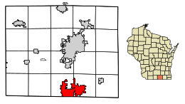 Location of Beloit in Rock County, Wisconsin | |
| Coordinates: 42°30′30″N 89°01′54″W / 42.50833°N 89.03167°W | |
| Country | |
| State | |
| County | Rock |
| Founded | 1836 |
| Incorporated | February 24, 1846 (village) March 31, 1856 (city) |
| Area | |
| • City | 17.66 sq mi (45.73 km2) |
| • Land | 17.33 sq mi (44.89 km2) |
| • Water | 0.33 sq mi (0.84 km2) |
| Elevation | 751 ft (228.9 m) |
| Population | |
| • City | 36,966 |
| • Estimate (2019)[3] | 36,926 |
| • Density | 2,130.51/sq mi (822.60/km2) |
| • Metro | 160,331 |
| Time zone | UTC-6 (CST) |
| • Summer (DST) | UTC-5 (CDT) |
| Area code(s) | 608 |
| FIPS code | 55-06500 |
| Website | www.beloitwi.gov |

Beloit is a city in Rock County, Wisconsin, United States. As of the 2010 census, the city had a population of 36,966 people.[4][5]
History[]
Twelve men in Colebrook, New Hampshire, created the "New England Emigrating Company" in October 1836 and sent Horace White to find a suitable region of Wisconsin in which to settle. The level fields and the water power of Turtle Creek and "unlimited gravel" in the area around what is now Beloit fixed the site of the village and farms. White purchased the land. At the same time as the Colebrook settlers, six families from Bedford, New Hampshire, arrived and settled in the region. They said the Rock River Valley had a "New England look" that made them feel at home. The village was platted in 1838 and was planned with wide streets, building on the New England model.
Beloit was originally named New Albany (after Albany, Vermont) in 1837 by its founder, Caleb Blodgett. The name was changed to Beloit in 1838.[6][7] The name was coined to be reminiscent of Detroit.[6]
Beloit lays claim to such inventions as the speedometer,[8] Korn Kurls,[9] and John Francis Appleby's twine binder.[10] Korn Kurls, which resemble Cheetos, was the original puffed cheese snack.[11][12]

Historic buildings[]
Beloit's 1889 Water Tower Place began demolition in 1935, which was halted because of the cost. A historic pump station is nearby.
The Fairbanks Flats were built in 1917 to house the rush of African Americans moving to the area from the Southern United States.
Pearsons Hall of Science was designed by the architectural firm Burnham and Root for Beloit College as a science center.
The Lathrop-Munn Cobblestone House was originally built for politician John Hackett.
The Castle at 501 Prospect was built as First Presbyterian Church in 1902. It now operates as a Performing Arts Center and Music School.
Downtown Beloit and the riverfront[]
Downtown Beloit is the city's historic economic, cultural and social center. North of the confluence of the Rock River and Turtle Creek, the downtown is anchored by a core of historic buildings and the Ironworks office and industrial campus. Beloit's riverfront park system, mainly Riverside Park, extends north of downtown along the east bank toward the Town of Beloit.
Downtown Beloit is one of two inaugural members of the Wisconsin Main Street designation.[13]
Railroad heritage[]
Beloit was served by the Chicago, Milwaukee, St. Paul and Pacific Railroad, better known as the Milwaukee Road, and the Chicago & North Western Railroad (C&NW). In its 1980 bankruptcy, the Milwaukee Road disposed of the Southwestern Line. The Union Pacific Railroad, which took over the C&NW, operates in Beloit today over a remnant of the former Milwaukee Road, providing a rail connection to Fairbanks-Morse Engine manufacturing facility.[clarification needed] The Canadian Pacific Railway operates other trackage in Beloit.[14] The city also had an electric interurban railroad.[when?]
Geography[]
According to the United States Census Bureau, the city has an area of 17.70 square miles (45.84 km2), of which 17.37 square miles (44.99 km2) is land and 0.33 square miles (0.85 km2) is water.[15] Location: 42°30′30″N 89°01′54″W / 42.50833°N 89.03167°W.
The city is adjacent to the Town of Beloit, Town of Turtle, and the Illinois municipality of South Beloit.
Most of Beloit's development is occurring on the east side, adjacent to Interstates 39/90 and Interstate 43, where the city annexed rural land for Beloit Gateway Industrial Park, as well as in the newly revitalized downtown along the Rock River.
Climate[]
| ||||||||||||||||||||||||||||||||||||||||||||||||||||||||||||||||||||||||||||
| hideClimate data for Beloit, Wisconsin (1991–2020 normals, extremes 1893–present) | |||||||||||||
|---|---|---|---|---|---|---|---|---|---|---|---|---|---|
| Month | Jan | Feb | Mar | Apr | May | Jun | Jul | Aug | Sep | Oct | Nov | Dec | Year |
| Record high °F (°C) | 61 (16) |
69 (21) |
84 (29) |
92 (33) |
103 (39) |
104 (40) |
110 (43) |
102 (39) |
100 (38) |
89 (32) |
78 (26) |
66 (19) |
110 (43) |
| Average high °F (°C) | 25.1 (−3.8) |
29.4 (−1.4) |
41.5 (5.3) |
54.8 (12.7) |
66.5 (19.2) |
76.1 (24.5) |
79.6 (26.4) |
78.0 (25.6) |
71.3 (21.8) |
58.3 (14.6) |
43.2 (6.2) |
30.5 (−0.8) |
54.5 (12.5) |
| Daily mean °F (°C) | 17.9 (−7.8) |
21.6 (−5.8) |
32.7 (0.4) |
44.6 (7.0) |
56.1 (13.4) |
65.9 (18.8) |
69.7 (20.9) |
68.1 (20.1) |
60.8 (16.0) |
48.5 (9.2) |
35.3 (1.8) |
23.8 (−4.6) |
45.4 (7.4) |
| Average low °F (°C) | 10.7 (−11.8) |
13.9 (−10.1) |
23.8 (−4.6) |
34.4 (1.3) |
45.7 (7.6) |
55.8 (13.2) |
59.8 (15.4) |
58.1 (14.5) |
50.3 (10.2) |
38.7 (3.7) |
27.4 (−2.6) |
17.0 (−8.3) |
36.3 (2.4) |
| Record low °F (°C) | −29 (−34) |
−28 (−33) |
−13 (−25) |
7 (−14) |
26 (−3) |
34 (1) |
42 (6) |
39 (4) |
23 (−5) |
4 (−16) |
−12 (−24) |
−25 (−32) |
−29 (−34) |
| Average precipitation inches (mm) | 1.60 (41) |
1.52 (39) |
2.13 (54) |
3.72 (94) |
4.34 (110) |
5.64 (143) |
3.36 (85) |
4.14 (105) |
3.83 (97) |
2.77 (70) |
2.40 (61) |
1.96 (50) |
37.41 (950) |
| Average snowfall inches (cm) | 9.8 (25) |
7.3 (19) |
4.3 (11) |
1.1 (2.8) |
0.0 (0.0) |
0.0 (0.0) |
0.0 (0.0) |
0.0 (0.0) |
0.0 (0.0) |
0.2 (0.51) |
2.7 (6.9) |
10.2 (26) |
35.6 (90) |
| Average precipitation days (≥ 0.01 in) | 8.7 | 7.1 | 8.4 | 10.3 | 11.7 | 10.6 | 8.9 | 8.7 | 7.6 | 9.1 | 8.0 | 8.6 | 107.7 |
| Average snowy days (≥ 0.1 in) | 6.2 | 4.5 | 2.3 | 0.6 | 0.0 | 0.0 | 0.0 | 0.0 | 0.0 | 0.1 | 0.8 | 4.6 | 19.1 |
| Source: NOAA[17][18] | |||||||||||||
Demographics[]
| Historical population | |||
|---|---|---|---|
| Census | Pop. | %± | |
| 1860 | 4,098 | — | |
| 1870 | 4,396 | 7.3% | |
| 1880 | 4,790 | 9.0% | |
| 1890 | 6,315 | 31.8% | |
| 1900 | 10,436 | 65.3% | |
| 1910 | 15,125 | 44.9% | |
| 1920 | 21,284 | 40.7% | |
| 1930 | 23,611 | 10.9% | |
| 1940 | 25,365 | 7.4% | |
| 1950 | 29,590 | 16.7% | |
| 1960 | 32,846 | 11.0% | |
| 1970 | 35,729 | 8.8% | |
| 1980 | 35,207 | −1.5% | |
| 1990 | 35,573 | 1.0% | |
| 2000 | 35,775 | 0.6% | |
| 2010 | 36,966 | 3.3% | |
| 2019 (est.) | 36,926 | [3] | −0.1% |
| U.S. Decennial Census[19] | |||
2010 census[]
As of the census[2] of 2010, there were 36,966 people, 13,781 households, and 8,867 families residing in the city. The population density was 2,128.2 inhabitants per square mile (821.7/km2). There were 15,177 housing units at an average density of 873.7 per square mile (337.3/km2). The racial makeup of the city was 68.9% White, 15.1% African American, 0.4% Native American, 1.1% Asian, 10.0% from other races, and 4.4% from two or more races. Hispanic or Latino of any race were 17.1% of the population.
There were 13,781 households, of which 36.5% had children under the age of 18 living with them, 39.6% were married couples living together, 18.3% had a female householder with no husband present, 6.4% had a male householder with no wife present, and 35.7% were non-families. 29.4% of all households were made up of individuals, and 11.2% had someone living alone who was 65 years of age or older. The average household size was 2.57 and the average family size was 3.16.
The median age in the city was 33.1 years. 27.1% of residents were under the age of 18; 12.1% were between the ages of 18 and 24; 25.7% were from 25 to 44; 23.1% were from 45 to 64; 12% were 65 years of age or older. The gender makeup of the city was 47.9% male and 52.1% female.
Government[]
Beloit is represented by Janis Ringhand and Stephen Nass in the Wisconsin State Senate, Amy Loudenbeck and Mark Spreitzer in the Wisconsin State Assembly, Mark Pocan in the United States House of Representatives, and Ron Johnson and Tammy Baldwin in the United States Senate.
Beloit has a council-manager system of government, with seven council members, each elected for two-year terms. Four members are elected in even years and three in odd years. City council elections are held annually in April.[20] The city council establishes policies for the city and appoints a city manager to implement those policies. The current city manager, Lori S. Curtis Luther, was appointed on June 1, 2015.[21]
Economy[]
Industries with headquarters in Beloit include ABC Supply Company, Bio-Systems International, Broaster Company, Fairbanks-Morse Defense, Hendricks Holding Company, Murmac Paint Manufacturing, PlayMonster, and Regal Beloit.
Downtown Beloit is a dense cluster of mostly small shops and boutiques. The area has been recognized for increased investment and renewal since the 1990s.[22] Upscale downtown condominiums and hotels were introduced after 2000 with the construction of the Hotel Hilton Apartments (2001), the Beloit Inn (now the Ironworks Hotel, 2003), Heritage View (2005), and the Phoenix Project (2013).
From the 1990s to 2011, downtown Beloit received direct public and private investment totaling more than $75 million.[22] In 2011, Beloit was a Great American Main Street Award winner.[23] In 2012, Beloit was listed #17 on Travel and Leisure's list of America's Greatest Mainstreets.[24][25]
Education[]
The School District of Beloit serves more than 6,800 students in six primary schools, four intermediate schools, and one high school, with alternative programming and charter schools. Beloit Memorial High School is the city's public high school. The Roy Chapman Andrews Academy, a project-based charter school, is part of the School District of Beloit and serves grades 6 through 12.

Beloit College, a private liberal arts college with undergraduate enrollment around 1,300, is in the city. The campus has a number of prehistoric Native American mounds.
Blackhawk Technical College, a public technical school, has a campus in downtown Beloit.
Beloit is also home to Concordia University's Beloit location, Beloit Center. The center offers courses designed for working adults interested in getting their associate's, bachelor's, and graduate degrees.[26]
Beloit has a public library that is part of the Arrowhead Library System.
Media[]
Beloit's main newspaper is The Beloit Daily News, a daily (published Monday through Friday) paper owned by Adams Publishing Group, LLC, and serving the Wisconsin/Illinois stateline area. The Janesville Gazette, also owned by Adams Publishing Group, also serves Beloit.
Beloit is a part of the Madison television market, but due to its proximity to Rockford, stations from Rockford also serve the city and report on stories and information (weather, school closings, etc.) relating to Beloit.
Radio stations serving Beloit include WBCR (90.3 FM), a variety-formatted station owned by The Board of Trustees of Beloit College, '90s hits station WBEL (1380 AM), classic country station WGEZ (1490 AM), Janesville-based stations WCLO (1230 AM) and WJVL (99.9 FM), and Fort Atkinson-based WSJY (107.3 FM).
Culture[]
- Beloit Art Center
- Beloit Civic Theatre
- Beloit Historical Society
- Beloit Janesville Symphony Orchestra
- The Castle Performing Arts Center
- Logan Museum of Anthropology
- Turtle Creek Chamber Orchestra
- Wright Museum of Art
- Beloit City Hall – this houses a mural portraying the history of Beloit, completed in 1985 by artist Martha Nessler Hayden.[27]
Festivals[]
Beloit's main festivals include:
- Beloit Autorama
- Beloit Farmers' Market
- Beloit International Film Festival
- Dancing at Harry's Place
- Downtown Beloit Street Dance
- Fridays in the Park
- Music at Harry's Place
- Winterfest
Recreation[]
Beloit is home to a professional minor league baseball team, the Beloit Snappers, who play in the Midwest League and are the High A affiliate of the Miami Marlins. The Snappers play their games at the Harry C. Pohlman Field. On August 3, 2021, they will begin playing at the new ABC Supply Stadium.
Transportation[]
Transit[]
The Beloit Transit System is the primary provider of mass transportation. Four regular routes provide service from Monday through Saturday. In collaboration with the Janesville Transit System, BTS operates an express route between the two cities.
Routes[]
- Red East Side Cranston
- Blue West Side
- Yellow North End-Prairie
- Brown Beloit-Janesville
Roads[]
This list is incomplete; you can help by . (July 2020) |
| Interstate 90 Westbound (Northbound) routes to Janesville and Madison. Eastbound (Southbound) routes to Rockford, Illinois. This is a full interstate grade freeway that runs on the east side of the city, although the I-90 is overall a west/east interstate the section in Beloit runs north/south. | |
| Interstate 39 runs entirely concurrently with Interstate 90 through the city of Beloit. | |
| Interstate 43 terminates at I-90/39 in Beloit, it routes Northbound to Milwaukee | |
| U.S. Route 51 runs through the center and partly the south side of the city. Northbound routes to Janesville, Madison, and Wausau. Southbound routes to South Beloit, Illinois and Rockford. |
Air[]
Beloit Airport is a small public-use GA airport within the city. It offers hangars for storing aircraft, gliders, and sky diving.
Southern Wisconsin Regional Airport is a public airport north of Beloit in Rock County. Formerly known as Rock County Airport, it is owned and operated by the Rock County government. The airport has no scheduled commercial passenger service.
Dane County Regional Airport and Rockford International Airport are the closest airports to Beloit that offer scheduled airline service.
Recognition[]
- Beloit is the only city in Rock County to have been named an All-America City.[28]
- Beloit was one of Travel + Leisure's top 20 Greatest American Main Streets[29] for 2014.
- The 2015 Milken Institute Best-Performing Cities Index ranked the Janesville-Beloit metropolitan area #4 by how well they created and sustained jobs and economic growth.
- In 2017, Beloit's main street was named one of five "Most Romantic" Main Streets for 2017 by National Main Street Center.[30]
Notable people[]
- Thomas Ryum Amlie, U.S. Representative
- Marcia Anderson, U. S. Army Major General
- Roy Chapman Andrews, adventurer and naturalist
- Fred Ascani, U.S. Air Force Major General
- Alan E. Ashcraft, Jr., Illinois State Representative
- Clinton Babbitt, U.S. Representative
- George B. Belting, Wisconsin State Representative
- Jim Breton, MLB player
- Jason W. Briggs, leader in development of Reorganized Church of Jesus Christ of Latter Day Saints
- James A. Brittan, Wisconsin State Representative
- Tony Brizzolara, MLB player
- Richard Burdge, Wisconsin State Senator
- Jackson J. Bushnell, educator
- Jim Caldwell, Beloit Memorial High School alumnus, former head coach of NFL's Detroit Lions
- Thomas Chrowder Chamberlin, geologist
- Franklin Clarke, professional football player for Dallas Cowboys (1960–1967) and Cleveland Browns (1957–1959)
- Lawrence E. Cunningham, Wisconsin State Senator
- Horatio N. Davis, Wisconsin State Senator
- Delmar DeLong, Wisconsin State Representative
- Burger M. Engebretson, Wisconsin State Representative
- John E. Erickson, NBA executive
- Betty Everett, rock and jazz singer ("The Shoop Shoop Song")
- Edward A. Everett, Wisconsin State Representative
- The Felix Culpa, post-hardcore band
- Dorr Felt, inventor of comptometer
- Edwin G. Fifield, Wisconsin State Representative
- Bill Flannigan, NFL player
- Patsy Gharrity, MLB player
- Danny Gokey, American Idol contestant, choir director at a Beloit church
- Bernie Graham, professional baseball player
- John Hackett, businessman and politician
- Jim Hall, professional boxer
- Edward F. Hansen, Wisconsin State Representative
- William O. Hansen, Wisconsin State Representative
- Bill Hanzlik, NBA player and coach
- Jonathan Harr, journalist and author of A Civil Action
- Ken Hendricks, founder of ABC Supply, listed on the Forbes 400
- William H. Hurlbut, Wisconsin State Representative
- Gary Johnson, elected majority leader of Wisconsin Assembly in 1980 and 1983[31]
- Jerry Kenney, baseball player for New York Yankees (1967, 1969–1972) and Cleveland Indians (1973)
- John Baxter Kinne, Medal of Honor recipient
- Stephanie Klett, television personality, Miss Wisconsin 1992
- Gene Knutson, NFL player
- Richard LaPiere, sociologist at Stanford University
- Eugene Lee, Tony Award-winning set designer (Wicked, Saturday Night Live)
- Wallace Leschinsky, Wisconsin State Representative
- Alonzo J. Mathison, Wisconsin State Representative
- Max Maxfield, Wyoming Secretary of State
- Juan Conway McNabb (John Conway McNabb), Roman Catholic bishop, missionary in Peru
- Dr. Edward Strong Merrill, Wisconsin Athletic Hall of Fame, multi-sport athlete, Beloit College, '02[32]
- Sereno Merrill, Wisconsin State Representative
- Elmer Miller, MLB player
- Tommy Mills, head coach of Creighton Bluejays, Georgetown Hoyas and Arkansas State Indians football teams; Creighton and Arkansas State men's basketball, Notre Dame Fighting Irish baseball
- Orsen N. Nielsen, U.S. diplomat
- David Noggle, Wisconsin State Representative, Chief Justice of Supreme Court of Idaho Territory
- Russ Oltz, NFL player
- Terell Parks, professional basketball player
- Danica Patrick, Indy Car & NASCAR auto racing driver and model
- George Perring, MLB player
- Samuel L. Plummer, Wisconsin State Representative
- Alan S. Robertson, Wisconsin State Representative
- Robert P. Robinson, Wisconsin State Senator
- Judy Robson, former majority leader, Wisconsin Senate
- David Roth, opera director
- Jane Sherman, actress, writer, composer, dancer with The Rockettes
- Richard Shoemaker, Wisconsin State Senator
- Tracy Silverman, violinist
- Mark Simonson, font designer
- Erastus G. Smith, Wisconsin State Representative
- Simon Smith, Wisconsin State Representative
- Robert C. Strong, U.S. diplomat
- William Barstow Strong, former president of Atchison, Topeka and Santa Fe Railway
- Tyree Talton, NFL player
- Rusty Tillman, NFL player and assistant coach, XFL head coach
- S. J. Todd, Wisconsin State Senator
- Marijuana Pepsi Vandyck, education professional
- Allen F. Warden, Wisconsin State Representative
- Arthur Pratt Warner, aviator and inventor
- Kyle Weaver, professional basketball player for Oklahoma City Thunder
- Floyd E. Wheeler, Wisconsin State Representative and lawyer
- John D. Wickhem, Justice of Wisconsin Supreme Court
- Albert J. Winegar, Wisconsin State Representative
- Zip Zabel, MLB player
- Robin Zander, musician (Cheap Trick)
Images[]

Fairbanks-Morse
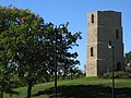
Beloit Water Tower, constructed in 1889

Beloit Ironworks, a group of restored industrial buildings along the city's downtown riverfront

Middle College, on the Beloit College campus, Wisconsin's oldest academic building still in use


See also[]
References[]
- ^ "2019 U.S. Gazetteer Files". United States Census Bureau. Retrieved August 7, 2020.
- ^ Jump up to: a b "U.S. Census website". United States Census Bureau. Retrieved 2012-11-18.
- ^ Jump up to: a b "Population and Housing Unit Estimates". United States Census Bureau. May 24, 2020. Retrieved May 27, 2020.
- ^ "U.S. Census website". United States Census Bureau. Retrieved 2008-01-31.
- ^ "American FactFinder - Results". Archived from the original on 2014-03-05. Retrieved 2012-04-19.
- ^ Jump up to: a b Callary, Edward. 2009. Place Names of Illinois. Champaign: University of Illinois Press, p. 326.
- ^ "Frank Blodgett Dies at Age 82". Janesville Daily Gazette. March 21, 1949. p. 1. Retrieved August 26, 2014 – via Newspapers.com.

- ^ D.V.M., Ralph S. Cooper. "Arthur P. Warner". www.earlyaviators.com. Archived from the original on 17 May 2016. Retrieved 21 June 2017.
- ^ Beloit Historical Society Archived July 8, 2008, at the Wayback Machine
- ^ Appleby, John Francis 1840 - 1917 Archived February 10, 2009, at the Wayback Machine
- ^ "REMEMBER - This Is Beloit |". This Is Beloit |. Archived from the original on 2017-05-22. Retrieved 2017-02-01.CS1 maint: bot: original URL status unknown (link)Internet Archive: Retrieved May 26, 2018
- ^ Atlas Obscura: Brief History of the Cheese Curl Retrieved May 26, 2018
- ^ "Wisconsin Main Street map and founding years" (PDF). Wisconsin Main Street Association. Archived from the original (PDF) on 2013-09-27. Retrieved 26 September 2013.
- ^ "Beloit, WI, Operations". www.glenviewcreek.com. Archived from the original on 15 November 2017. Retrieved 21 June 2017.
- ^ "US Gazetteer files 2010". United States Census Bureau. Archived from the original on 2012-07-02. Retrieved 2012-11-18.
- ^ "NASA Earth Observations Data Set Index". NASA. Retrieved 30 January 2016.
- ^ "NowData – NOAA Online Weather Data". National Oceanic and Atmospheric Administration. Retrieved June 22, 2021.
- ^ "Station: Beloit, WI". U.S. Climate Normals 2020: U.S. Monthly Climate Normals (1991-2020). National Oceanic and Atmospheric Administration. Retrieved June 22, 2021.
- ^ "Census of Population and Housing". Census.gov. Retrieved June 4, 2015.
- ^ "City Council - Welcome to the City of Beloit". www.beloitwi.gov. Retrieved 2017-02-15.
- ^ "City Manager - Welcome to the City of Beloit". www.beloitwi.gov. Retrieved 2017-02-15.
- ^ Jump up to: a b "The 2011 Great American Main Street Award Winners". Preservation Nation. Archived from the original on 2013-09-27. Retrieved 26 September 2013.
- ^ Stewart, Erica (23 May 2011). "The 2011 Great American Main Street Award Winners: Places You'll Want to Know (and Visit!)". PreservationNation Blog. Archived from the original on 2013-10-20. Retrieved 26 September 2013.
- ^ "America's Greatest Mainstreets 2012".
- ^ Adams, Barry. "Downtown Beloit an Emerging Destination". Wisconsin State Journal. Retrieved 24 March 2014.
- ^ "Beloit - Concordia University Wisconsin". Concordia University Wisconsin. Archived from the original on 2017-02-16. Retrieved 2017-02-15.
- ^ Enking, Minnie (March 30, 1985). "Artist Finds Beauty in Beloit". Beloit Daily News. p. 84.
- ^ "Archived copy". Archived from the original on 2012-09-01. Retrieved 2019-10-13.CS1 maint: archived copy as title (link)
- ^ "Beloit, WI". Retrieved 21 June 2017.
- ^ "Most Romantic Main Streets 2017". mainstreet.org. Archived from the original on 2017-03-24. Retrieved 21 June 2017.
- ^ "Legislative Spotlight". www.legis.state.wi.us. Archived from the original on 4 September 2012. Retrieved 21 June 2017.
- ^ Wisconsin Athletic Hall of Fame, 1964 inductee
External links[]
| Wikimedia Commons has media related to Beloit, Wisconsin. |
| show Places adjacent to Beloit, Wisconsin |
|---|
| show Municipalities and communities of Rock County, Wisconsin, United States |
|---|

| show |
|---|

| show Great Lakes megaregion as defined by the RPA |
|---|

Coordinates: 42°30′30″N 89°01′54″W / 42.50833°N 89.03167°W
| show Authority control |
|---|
- Beloit, Wisconsin
- 1836 establishments in Wisconsin Territory
- Cities in Wisconsin
- Cities in Rock County, Wisconsin
- Populated places established in 1836