Blitar
Blitar | |
|---|---|
 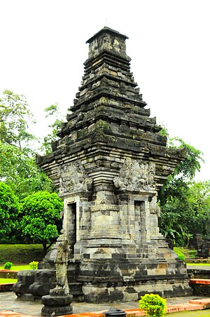   Clockwise, from top left : Sukarno Mausoleum, Penataran Temple, Plumbangan Temple, | |
 Coat of arms | |
| Motto(s): Kridha Hangudi Jaya | |
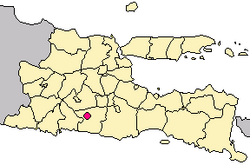 Location within East Java | |
| Coordinates: 8°06′S 112°09′E / 8.100°S 112.150°ECoordinates: 8°06′S 112°09′E / 8.100°S 112.150°E | |
| Country | |
| Province | |
| City | April 1, 1906 |
| Government | |
| • Mayor | Muhammad Samanhudi Anwar |
| • Vice Mayor | Santoso |
| Area | |
| • Total | 32.57 km2 (12.58 sq mi) |
| Elevation | 167 m (548 ft) |
| Population (2020 Census) | |
| • Total | 149,149 |
| • Density | 4,600/km2 (12,000/sq mi) |
| [1] | |
| Time zone | UTC+7 (Indonesia Western Time) |
| Postcode | 66100 |
| Area code | (+62) 342 |
| Vehicle registration | AG |
| Website | blitarkota |


Blitar is a landlocked city in East Java, Indonesia, about 73 km from Malang and 167 km from Surabaya. The area lies within longitude 111° 40' – 112° 09' East and its latitude is 8° 06' South. The city of Blitar lies at an altitude on average 167 metres above sea level,[2] and is a enclave within Blitar Regency which surrounds the city on all sides.
The city is noted as the location of the grave of Sukarno, the first President of Indonesia, five kilometers from the city plaza. The Istana Gebang (Gebang palace) where Sukarno lived as a child is nearby and has been converted into a museum. containing numerous items commemorating Sukarno's place in Indonesian history.[3] In addition, the very active Kelud volcano is located just over 20 kilometers north of Blitar.
Administrative districts[]
Blitar city is divided into three districts (kecamatan), tabulated below with their areas and population totals from the 2010 Census[4] and the 2020 Census.[5]
| Name | Area in km2 |
Population Census 2010[6] |
Population Census 2020[7] |
|---|---|---|---|
| Sukorejo | 9.92 | 44,043 | 51,990 |
| Kepanjenkidul | 10.50 | 38,715 | 41,680 |
| Sawanwetan | 12.15 | 49,210 | 55,470 |
| Totals | 32.57 | 131,968 | 149,149 |
Local economic governance[]
Based on the survey conducted between August 2010 and January 2011, Blitar was rated number one in Indonesia for local economic governance, being considered particularly good in infrastructure, interaction between local administrations and businesses, business licensing, and regional head capacity and integrity.[8]
Sukarno's Mausoleum[]
It is located at Bendogerit village, Sunan wetan district, about 2 kilometers from Blitar city.
The tomb is built in East Javanese "Joglo" architectural pattern, and combined with Gateway of Bentar. The mausoleum is 51 feet high, with a copper roof of three-tier building. Underneath, Sukarno's plot is flanked by that of his mother and father. A stone of black andesite bears the inscription, "Here lies Bung Karno, proclaimer of independence, first president of Indonesia." Beside the main building of the tomb, the graveyard complex has Gapura Agung (The Great Gate), Mosque, hall, park, rest area and parking place.
The tomb is opened to public, attracts a large number of visitors, both domestic and international. About 1.5 million people visit the tomb annually.[9]
People from Blitar[]

- Boediono -Former Vice President of Indonesia.
- Admiral Agus Suhartono – Former commander-in-chief of the Indonesian military.
- Livi Zheng, film producer and director
- , basketball coach, national player
- , businessman
- Charis Yulianto, footballer
- Nitya Krishinda Maheswari, badminton athlete
- , inventor and director/pilot of Garuda Indonesia
- Anjasmara, actor
- Anthony Fokker, aviation pioneer
- Sukadji Ranuwihardjo, academic
- Anas Urbaningrum, politician
- , politician
- Masjchun Sofwan, politician
- Sukarni, politician
- Agus Suhartono, military leader
- , actor
- Putri Raemawasti, beauty queen, Miss Indonesia 2007
- Hardi, painter
Climate[]
Blitar has a tropical monsoon climate (Am) with moderate to little rainfall from June to October and heavy rainfall from November to May.
| hideClimate data for Blitar | |||||||||||||
|---|---|---|---|---|---|---|---|---|---|---|---|---|---|
| Month | Jan | Feb | Mar | Apr | May | Jun | Jul | Aug | Sep | Oct | Nov | Dec | Year |
| Average high °C (°F) | 28.8 (83.8) |
28.9 (84.0) |
29.2 (84.6) |
29.5 (85.1) |
29.6 (85.3) |
29.8 (85.6) |
29.6 (85.3) |
30.0 (86.0) |
30.7 (87.3) |
30.9 (87.6) |
30.0 (86.0) |
29.3 (84.7) |
29.7 (85.4) |
| Daily mean °C (°F) | 24.6 (76.3) |
24.7 (76.5) |
24.9 (76.8) |
24.9 (76.8) |
24.6 (76.3) |
24.3 (75.7) |
23.7 (74.7) |
23.9 (75.0) |
24.6 (76.3) |
25.1 (77.2) |
25.0 (77.0) |
24.8 (76.6) |
24.6 (76.3) |
| Average low °C (°F) | 20.5 (68.9) |
20.6 (69.1) |
20.6 (69.1) |
20.4 (68.7) |
19.7 (67.5) |
18.8 (65.8) |
17.9 (64.2) |
17.9 (64.2) |
18.6 (65.5) |
19.4 (66.9) |
20.0 (68.0) |
20.3 (68.5) |
19.6 (67.2) |
| Average rainfall mm (inches) | 296 (11.7) |
271 (10.7) |
265 (10.4) |
191 (7.5) |
131 (5.2) |
81 (3.2) |
45 (1.8) |
24 (0.9) |
32 (1.3) |
102 (4.0) |
191 (7.5) |
283 (11.1) |
1,912 (75.3) |
| Source: Climate-Data.org[10] | |||||||||||||
See also[]
References[]
- ^ Badan Pusat Statistik, Jakarta, 2021.
- ^ "BPS Provinsi Jawa Timur". jatim.bps.go.id. Retrieved 2018-09-09.
- ^ "Archived copy". Archived from the original on 2014-06-06. Retrieved 2014-06-06.CS1 maint: archived copy as title (link)
- ^ Biro Pusat Statistik, Jakarta, 2011.
- ^ Badan Pusat Statistik, Jakarta, 2021.
- ^ Biro Pusat Statistik, Jakarta, 2011.
- ^ Badan Pusat Statistik, Jakarta, 2021.
- ^ The Jakarta Post. "Blitar Leads Economic Governance Survey". Retrieved June 3, 2016.
- ^ "Even in Death, Sukarno Wins Tribute From Indonesians". The Washington Post. Retrieved 7 January 2020.
- ^ "Climate: Blitar". Climate-Data.org. Retrieved 16 November 2020.
External links[]
| Wikivoyage has a travel guide for Blitar. |
- Witton, Patrick (2003). Indonesia (7th ed.). Melbourne: Lonely Planet. pp. 285–286. ISBN 1-74059-154-2.
- (in Indonesian) Official site of Blitar City
- (in Indonesian) Official site of Blitar Regency
- Heraldry of Blitar
- (Indonesian) Blitar Tourism Information
- (Indonesian) Blitar Local Information
- (Indonesian) Blitar Backpacker Information
| show Places adjacent to Blitar |
|---|

| show Authority control |
|---|
- Blitar
- Sukarno
- 1906 establishments in the Dutch East Indies