Mojokerto Regency
Mojokerto Regency
Kabupaten Mojokerto ꦑꦧꦸꦥꦠꦺꦤ꧀ꦩꦗꦏꦼꦂꦠ | |
|---|---|
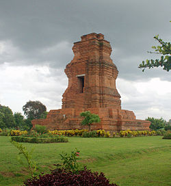 Brahu Temple Trowulan at the town of Trowulan | |
 Coat of arms | |
| Motto(s): Wijna Mantriwira (Wise and courageous for the country) | |
 Location within East Java | |
| Coordinates: 7°33′S 112°30′E / 7.550°S 112.500°E | |
| Country | |
| Province | East Java |
| Capital | |
| Government | |
| • Regent | Pungkasiadi |
| • Vice Regent | vacant |
| Area | |
| • Total | 692.15 km2 (267.24 sq mi) |
| Population (mid 2019)[1] | |
| • Total | 1,159,593 |
| • Density | 1,700/km2 (4,300/sq mi) |
| Time zone | UTC+7 (IWST) |
| Area code | (+62) 321 |
| Website | mojokertokab |


Mojokerto Regency (Indonesian: Kabupaten Mojokerto; Javanese: ꦑꦧꦸꦥꦠꦺꦤ꧀ꦩꦗꦏꦼꦂꦠ, romanized: Kabupatèn Måjåkertå) is a regency in East Java Province of Indonesia. It is part of the Surabaya metropolitan area (known as Gerbangkertosusila) which comprises Gresik Regency, Bangkalan Regency, Mojokerto Regency, Mojokerto City, Surabaya City, Sidoarjo Regency, and Lamongan Regency. The Regency covers an area of 692.15 sq. km (excluding the independent city of Mojokerto). The population of the Regency was 908,004 in 2000, but had risen to 1,025,443 at the 2010 Census;[2] the latest official estimate (as at mid 2019) is 1,159,593.[3] Many of them earn their living as small farmers and craftsmen (consisting shoemakers, furniture makers, and souvenir makers).
The administrative capital is the town of .
Administrative Districts[]
The Regency is divided into eighteen districts (kecamatan), tabulated below with their areas and population totals from the 2010 Census[4] and the official estimates for mid 2019.[5] The table also includes the number of administrative villages (rural desa and urban kelurahan) in each district, and its postal codes.
| Name | Area in km2 |
Population Census 2010[6] |
Population Estimate mid 2019[7] |
Number of villages |
Post codes |
|---|---|---|---|---|---|
| Jatirejo | 32.98 | 39,713 | 45,727 | 19 | 61373 |
| Gondang | 39.11 | 38,850 | 44,905 | 18 | 61372 |
| Pacet | 45.16 | 53,015 | 60,940 | 20 | 61374 |
| Trawas | 29.86 | 28,302 | 31,781 | 13 | 61375 |
| Ngoro | 57.48 | 79,469 | 85,591 | 19 | 61385 |
| Pungging | 48.14 | 71,934 | 81,187 | 19 | 61384 |
| Kutorejo | 42.83 | 57,527 | 67,749 | 17 | 61383 |
| Mojosari | 26.65 | 73,945 | 81,806 | 18 | 61382 |
| Bangsal | 24.06 | 46,625 | 53,536 | 17 | 61381 |
| Mojoanyar | 23.02 | 46,466 | 51,409 | 12 | 61363 & 31364 |
| Dlanggu | 35.42 | 50,064 | 58,438 | 16 | 61371 |
| Puri | 35.65 | 70,463 | 79,487 | 16 | 61363 & 31364 |
| Trowulan | 39.20 | 68,154 | 77,881 | 16 | 61362 |
| Sooko | 23.46 | 69,059 | 75,222 | 15 | 61361 |
| Totals for Southern zone |
503.02 | 792,286 | 895,709 | 236 | |
| Gedeg | 22.98 | 52,700 | 60,510 | 14 | 61351 |
| Kemlagi | 50.05 | 52,793 | 61,424 | 20 | 61353 |
| Jetis | 57.17 | 79,967 | 88,596 | 16 | 61352 |
| Dawar Blandong | 58.93 | 47,697 | 53,354 | 18 | 61354 |
| Totals for Northern zone |
189.13 | 233,157 | 263,884 | 68 | |
| Totals for Regency |
692.15 | 1,025,443 | 1,159,593 | 304 |
The city of Mojokerto, which since 1999 has been administratively independent of the Regency (although the regency administration remains at present centred on the city), virtually divides the regency into two zones - the southern zone comprising the first 14 districts listed above, and the smaller northern zone, comprising the last 4 districts listed above.
Neighbouring regencies[]
- Northern boundary: Gresik and Lamongan
- Southern boundary: Malang
- Eastern boundary: Sidoarjo and Pasuruan
- Western boundary: Jombang
Mojokerto Regency's area is 692.15 km2, located between 15 m and 3,156 m above sea level. It is divided into northern and southern regions by the Brantas River. The southern region has several mountains, which includes Welirang Mountain (3,156 m), Anjasmoro Mountain (2,277 m) and Penanggungan Mountain (1693m).
One of the more famous locations in Mojokerto is Pacet, which has a good mountainous view.
Sleeping Budha[]
The biggest Sleeping Budha Statue in Indonesia is in Maha Vihara Mojopahit Bejijong, Trowulan District, Mojokerto Regency. The statue is 22 metres in length, 6 metres in width and 4.5 metres in height.[8]
References[]
- ^ Badan Pusat Statistik, Jakarta, 2020.
- ^ Biro Pusat Statistik, Jakarta, 2011.
- ^ Badan Pusat Statistik, Jakarta, 2020.
- ^ Biro Pusat Statistik, Jakarta, 2011.
- ^ Badan Pusat Statistik, Jakarta, 2020.
- ^ Biro Pusat Statistik, Jakarta, 2011.
- ^ Badan Pusat Statistik, Jakarta, 2020.
- ^ "Patung Budha Tidur di Maha Vihara Dimandikan". May 19, 2019.
External links[]
| Wikimedia Commons has media related to Mojokerto Regency. |
Coordinates: 7°33′S 112°30′E / 7.550°S 112.500°E

| show Authority control |
|---|
This East Java location article is a stub. You can help Wikipedia by . |
- Mojokerto Regency
- East Java geography stubs