Bouar
Bouar
Buar[1] | |
|---|---|
 Bouar | |
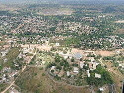
 Bouar Location in Central African Republic | |
| Coordinates: 5°57′N 15°36′E / 5.950°N 15.600°E | |
| Country | Central African Republic |
| Prefecture | Nana-Mambéré |
| Elevation | 1,046 m (3,432 ft) |
| Population (2012)[2] | |
| • Total | 39,205 |

Bouar is a market town in the western Central African Republic, lying on the main road from Bangui (437 km) to the frontier with Cameroon (210 km). The city is the capital of Nana-Mambéré prefecture, has a population of 40,353, while the whole sous-préfecture has a population of 96,595 (2003 census). Bouar lies on a plateau almost 1000m above sea level and is known as the site of Camp Leclerc, a French military base.
About seventy groups of megaliths lie in the town and to its north and east. The Bouar Megaliths, dating back to the very late Neolithic Era (c. 3500–2700 BC) were added to the UNESCO World Heritage Tentative List on April 11, 2006 in the Cultural category.[3]
History[]
Bouar was ceded by France to Germany under the terms of the 1912 Morocco-Congo Treaty, becoming part of the German colony of Neukamerun until it was reconquered by the French during World War I.[4] The town was occupied and burned down in the late 1920s by Gbaya rebels during the Kongo-Wara rebellion.
Civil war[]
On 28 March 2013 Bouar was captured by Séléka rebels.[5] On 26 October 2013 Bouar was attacked and captured by Anti-balaka militias resulting in more than 20 deaths.[6] As of February 2014 the town and region around Bouar were experiencing ethnic cleansing, principally against Muslim civilians.[7] A French journalist, Camille Lepage, was also killed and her body found in the car of Anti-balaka troops in the Bouar region in May, 2014.[8][9]
On 18 September 2017 city was recaptured by FACA from Anti-balaka.[10] On 20 December 2020 parts of city were captured by rebels from Coalition of Patriots for Change.[11] On 27 December entire city was captured by rebels.[12] After many clashes it was recaptured by government forces on 8 February 2021.[13]
Climate[]
Köppen-Geiger climate classification system classifies its climate as tropical wet and dry (Aw).[14]
| hideClimate data for Bouar | |||||||||||||
|---|---|---|---|---|---|---|---|---|---|---|---|---|---|
| Month | Jan | Feb | Mar | Apr | May | Jun | Jul | Aug | Sep | Oct | Nov | Dec | Year |
| Average high °C (°F) | 31 (88) |
32.2 (90.0) |
31 (88) |
29.8 (85.6) |
28.2 (82.8) |
27 (81) |
26 (79) |
25.5 (77.9) |
26.4 (79.5) |
27.8 (82.0) |
30.2 (86.4) |
30.7 (87.3) |
28.8 (84.0) |
| Daily mean °C (°F) | 24.4 (75.9) |
25.5 (77.9) |
25.2 (77.4) |
24.2 (75.6) |
23.4 (74.1) |
22.5 (72.5) |
21.9 (71.4) |
21.4 (70.5) |
22 (72) |
22.8 (73.0) |
23.9 (75.0) |
23.8 (74.8) |
23.4 (74.2) |
| Average low °C (°F) | 17.8 (64.0) |
18.9 (66.0) |
19.5 (67.1) |
19.2 (66.6) |
18.7 (65.7) |
18.1 (64.6) |
17.9 (64.2) |
17.4 (63.3) |
17.7 (63.9) |
17.9 (64.2) |
17.6 (63.7) |
16.9 (62.4) |
18.1 (64.6) |
| Average precipitation mm (inches) | 4 (0.2) |
15 (0.6) |
72 (2.8) |
109 (4.3) |
144 (5.7) |
170 (6.7) |
198 (7.8) |
258 (10.2) |
251 (9.9) |
176 (6.9) |
36 (1.4) |
5 (0.2) |
1,438 (56.7) |
| Source: Climate-Data.org, altitude: 969m[14] | |||||||||||||
Places of worship[]
Among the places of worship, they are predominantly Christian churches and temples : (Lutheran World Federation), Evangelical Baptist Church of the Central African Republic (Baptist World Alliance), Roman Catholic Diocese of Bouar (Catholic Church).[15] There are also Muslim mosques.
See also[]
References[]
- ^ Buar (Variant) at GEOnet Names Server, United States National Geospatial-Intelligence Agency
- ^ "World Gazetteer". Archived from the original on 2013-01-11.
- ^ Les mégalithes de Bouar - UNESCO World Heritage Centre
- ^ Richard Bradshaw, Juan Fandos-Rius, Historical Dictionary of the Central African Republic, Rowman & Littlefield, USA, 2016, p. 137
- ^ "Central African Republic Situation Report No. 9 (as of 28 March 2013)". 28 March 2013.
- ^ "Pillay Warns Violence In Central African Republic May Spin Out Of Control". 8 November 2013.
- ^ MSF, Trapped By Violence in Bouar, Central African Republic, (video) February 2014, https://www.youtube.com/watch?v=LfQuJnpVZvE
- ^ Camerpost, Centrafrique : une journaliste française « assassinée » dans la région de Bouar – 13/05/2014, http://www.camerpost.com/centrafrique-une-journaliste-francaise-assassinee-dans-la-region-de-bouar-13052014/ Archived 2014-06-06 at the Wayback Machine
- ^ Paris confirms French journalist murdered in CAR, DW, Date 13.05.2014, http://www.dw.de/paris-confirms-french-journalist-murdered-in-car/a-17633357
- ^ "Centrafrique : panique à Bouar, les Faca font des tirs". 19 September 2017.
- ^ "RCA : Bouar, la barrière de Yolé occupée par les rebelles". 20 December 2020.
- ^ "RCA : la ville de Bouar, tombée aux mains des rebelles le jour de vote, est toujours sous le choc". 30 December 2020.
- ^ "RCA : Bouar, la ville est désormais sans rebelles". 8 February 2021.
- ^ Jump up to: a b "Climate: Bouar - Climate graph, Temperature graph, Climate table". Climate-Data.org. Retrieved 9 October 2013.
- ^ J. Gordon Melton, Martin Baumann, ‘‘Religions of the World: A Comprehensive Encyclopedia of Beliefs and Practices’’, ABC-CLIO, USA, 2010, p. 531-532
Coordinates: 5°57′N 15°36′E / 5.950°N 15.600°E

| show Authority control |
|---|
- Populated places in the Central African Republic
- Populated places in Nana-Mambéré
- Sub-prefectures of the Central African Republic