Bourke, New South Wales
| Bourke New South Wales | |||||||||||||||
|---|---|---|---|---|---|---|---|---|---|---|---|---|---|---|---|
 Court house, former maritime court | |||||||||||||||
| Population | 1,824 (2016 census)[1] | ||||||||||||||
| Postcode(s) | 2840 | ||||||||||||||
| Elevation | 106 m (348 ft) | ||||||||||||||
| Location |
| ||||||||||||||
| LGA(s) | Bourke Shire | ||||||||||||||
| State electorate(s) | Barwon | ||||||||||||||
| Federal Division(s) | Parkes | ||||||||||||||
| |||||||||||||||
| |||||||||||||||

Bourke is a town in the north-west of New South Wales, Australia. The administrative centre and largest town in Bourke Shire, Bourke is approximately 800 kilometres (500 mi) north-west of the state capital, Sydney, on the south bank of the Darling River.
History[]
The location of the current township of Bourke on a bend in the Darling River is the traditional country of the Ngemba people.[2]
The first European-born explorer to encounter the river was Charles Sturt in 1828 who named it after Sir Ralph Darling, Governor of New South Wales. Having struck the region during an intense drought and a low river, Sturt dismissed the area as largely uninhabitable and short of any features necessary for establishing reliable industry on the land.

It was not until the mid-1800s following a visit by colonial surveyor and explorer Sir Thomas Mitchell in 1835 that settlement of the area began. Following tensions with the local people Mitchell built a small stockade to protect his men and named it Fort Bourke after then Governor Sir Richard Bourke. This first crude structure became the foundation for a fledgling community with a small number of agricultural and livestock farms established in the region shortly afterwards. The area started to flourish when its location on the Darling River had it recognised as a key trade centre, linking the nearby outback agricultural industries with the east coast trade routes via the Darling River.
Bourke was surveyed for a town in 1869 and soon established itself as the outback trade hub of New South Wales with several transportation industries setting up branches in the town. By the 1880s Bourke would host a Cobb & Co Coach Terminus, several paddle boat companies running the Darling and a bridge crossing the river that would allow for road transportation into the town.
Opened on 4 May 1883, the North Bourke Bridge was designed by J H Daniels and modified in 1895 and 1903 by E M de Burgh. Its construction was begun by David BailIie and completed by McCulloch and Company. The 1895 modifications led to improved designs for subsequent lift-span bridges. The bridge is the oldest moveable-span bridge in Australia and is the sole survivor of its type in New South Wales. It served for 114 years before being bypassed in 1997 when a new bridge carrying the Mitchell Highway was opened just downstream.[3]
By 1885 Bourke would be accessible by rail, confirming its position as a major inland transport hub. Like many outback Australian townships, Bourke would come to rely on camels for overland transport, and the area supported a large Afghan community that had been imported to drive the teams of camels. A small Afghan mosque that dates back to the 1900s can be found within Bourke cemetery.
As trade moved away from river transport routes, Bourke's hold on the inland trade industry began to relax. Whilst no longer considered a trade centre, Bourke serves instead as a key service centre for the state's north western regions. In this semi-arid outback landscape, sheep farming along with some small irrigated cotton crops comprise the primary industry in the area today.[4]
Bourke's traditional landholders endured a similar fate to indigenous people across Australia. Dispossessed of their traditional country and in occasional conflict with white settlers, they battled a loss of land and culture and were hit hard by European disease. While the population of the local Ngemba and Barkindji people around the town of Bourke had dwindled by the late 19th century, many continued to live a traditional lifestyle in the region. Others found employment on local stations working with stock and found their skill as trackers in high demand.
A large influx of displaced Aboriginal peoples from other areas in the 1940s saw Bourke's indigenous community grow and led to the establishment of a reserve in 1946 by the Aborigines Protection Board. The majority of indigenous settlers were Wangkumara people from the Tibooburra region.[5]
In 1962, local high jumper Percy Hobson became the first person of Aboriginal descent to win a Commonwealth Games gold medal for Australia in Perth. The 5 ft 10 in (1.78 m) tall Hobson jumped 13 in (33 cm) above his height to win the event with a Games record leap of 6 ft 11 in (2.11 m). Hobson was celebrated on his return to Bourke and greeted by a brass band playing "Hail the Conquering Hero".[6] A park and illustrated water tower now contribute to his memory.
Heritage listings[]


Bourke has a number of heritage-listed sites, including:
- 3-7 Meek Street: St Ignatius Roman Catholic Church and Convent[7]
- 45 Mitchell Street: Towers Drug Company Building[8]
- 47 Oxley Street: Bourke Post Office[9]
- Richard Street: Bourke Court House[10]
- 5 Richard Street: Ardsilla[11]
- 17 Sturt Street: Old London Bank Building[12]
- The North Bourke Bridge, opened in 1883, is on the Engineering Heritage Register. [13]
Population[]
In 2016, there were 1,824 people in Bourke.
- Aboriginal and Torres Strait Islander people made up 38.0% of the population.
- 78.1% of people were born in Australia and 80.2% spoke only English at home.
- The most popular (40.2%) religion was Catholicism.[1]
In Bourke today, there are 21 recognised indigenous language groups, including Ngemba, Barkindji, Wangkumara and Muruwari.
Climate[]

Under the Köppen–Geiger classification, Bourke has a hot semi-arid climate (BSh) with a mild amount of rainfall throughout the year. On 4 January 1903, Bourke recorded a maximum temperature of 49.7 °C (121.5 °F), making it tied for the highest temperature recorded anywhere in New South Wales with Menindee, which is located further to the south, and one of the highest maximums ever to be recorded in Australia.[14]
| hideClimate data for Bourke | |||||||||||||
|---|---|---|---|---|---|---|---|---|---|---|---|---|---|
| Month | Jan | Feb | Mar | Apr | May | Jun | Jul | Aug | Sep | Oct | Nov | Dec | Year |
| Record high °C (°F) | 49.7 (121.5) |
47.1 (116.8) |
43.0 (109.4) |
38.6 (101.5) |
32.1 (89.8) |
28.0 (82.4) |
26.5 (79.7) |
34.8 (94.6) |
38.9 (102.0) |
41.6 (106.9) |
46.6 (115.9) |
48.9 (120.0) |
49.7 (121.5) |
| Average high °C (°F) | 37.0 (98.6) |
35.5 (95.9) |
32.5 (90.5) |
28.1 (82.6) |
22.7 (72.9) |
18.7 (65.7) |
18.4 (65.1) |
21.3 (70.3) |
25.6 (78.1) |
29.9 (85.8) |
32.8 (91.0) |
35.2 (95.4) |
28.1 (82.6) |
| Average low °C (°F) | 22.1 (71.8) |
21.7 (71.1) |
18.4 (65.1) |
13.3 (55.9) |
8.4 (47.1) |
6.1 (43.0) |
4.2 (39.6) |
5.0 (41.0) |
9.3 (48.7) |
13.7 (56.7) |
17.5 (63.5) |
20.3 (68.5) |
13.3 (55.9) |
| Record low °C (°F) | 11.0 (51.8) |
11.0 (51.8) |
5.8 (42.4) |
1.8 (35.2) |
−1.7 (28.9) |
−3.0 (26.6) |
−3.5 (25.7) |
−2.7 (27.1) |
−0.6 (30.9) |
3.1 (37.6) |
7.0 (44.6) |
10.9 (51.6) |
−3.5 (25.7) |
| Average precipitation mm (inches) | 31.6 (1.24) |
34.6 (1.36) |
38.7 (1.52) |
23.9 (0.94) |
25.9 (1.02) |
33.9 (1.33) |
14.2 (0.56) |
12.5 (0.49) |
19.5 (0.77) |
20.4 (0.80) |
37.7 (1.48) |
37.2 (1.46) |
300.7 (11.84) |
| Average precipitation days | 5.1 | 5.2 | 4.8 | 3.3 | 4.5 | 6.8 | 4.5 | 3.3 | 4.3 | 4.6 | 6.1 | 4.6 | 57.1 |
| Source: [15] | |||||||||||||
Education[]

This section does not cite any sources. (September 2019) |
Bourke has many schools for preschool children, primary and high school students. The Bourke–Walgett school of distance education allows children to be schooled at home, from preschool to year 12.
Transportation[]

Bourke can be reached by the Mitchell Highway from both the north from Cunnamulla and from the southeast from Nyngan. Brewarrina and Walgett are located on the Kamilaroi Highway that has its western terminus in Bourke. Moree and Goondiwindi, located on the Newell Highway, connect to Bourke via various roads. Cobar via the Kidman Way, is connected from the south.
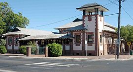
The town is also served by Bourke Airport and has NSW TrainLink bus service to other regional centres such as Dubbo. It was formerly the largest inland port in the world for exporting wool on the Darling River. The Bourke court house is unique in inland Australia in that it was originally a maritime court and to this day maintains that distinction. That distinction is evident in the crowns that sits above the finials of the flag poles atop the corner parapets of the building.
Prior to its closure, Bourke railway station was the terminus of the Main Western railway line. The railway extension from Byrock opened on 3 September 1885.[16] Passenger services on the line were cancelled in September 1975 with the line closing down entirely in 1986, leaving the station derelict.[17]
Cultural significance[]

Bourke is considered to represent the edge of the settled agricultural districts and the gateway to the outback that lies north and west of Bourke. This is reflected in a traditional east coast Australian expression "back o' Bourke" (from the poem by Scottish-Australian poet and bush balladeer Will H. Ogilvie.
The Tourist Information Centre is located on the Mitchell Highway at The Back 'O Bourke Exhibition Centre.[18]
In 1892 a young writer Henry Lawson was sent to Bourke by the Bulletin editor J.F. Archibald to get a taste of outback life and to try to curb his heavy drinking. In Lawson's own words "I got £5 and a railway ticket from the Bulletin and went to Bourke. Painted, picked up in a shearing shed and swagged it for six months". The experience was to have a profound effect on the 25-year-old and his encounter with the harsh realities of bush life inspired much of his subsequent work. Lawson would later write "if you know Bourke you know Australia". In 1992 eight poems, written under a pseudonym and published in the Western Herald, were discovered in the Bourke library archives and confirmed to be Lawson's work.[19]
Bush poets Harry 'Breaker' Morant (1864–1902)) and Will H. Ogilvie (1869–1963)) also spent time in the Bourke region and based much of their work on the experience.
Eye surgeon Fred Hollows was buried in Bourke after his death in 1993.[20] Fred Hollows had worked at Enngonia and around the Bourke area in the early 1970s and had asked to be buried there.
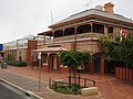
The Telegraph Hotel, established in 1888 beside the Darling River, has been restored and now operates as the Riverside Motel.[21]
Crime[]
In 2008, persistently high levels of criminal offending in Bourke led to a ban of the takeaway sales of beer in glass bottles, fortified wine larger than 750 mL and cask wine larger than two litres with only 3.5% or less alcohol non-glass bottles being sold midday.[22][23] A US-style justice reinvestment program was put in place to combat offending.[24]
Media[]

This section does not cite any sources. (September 2019) |
The town is served by seven FM and two AM radio stations, and five television channels.
The commercial radio stations are Rebel FM and The Breeze. Rebel FM broadcasts on 104.9 FM (MHz) and The Breeze broadcasts on 107.3 FM (MHz) from Mt Oxley, Bourke. Both stations are part of the Rebel Media group. ABC radio broadcasts on both the FM and AM bands and is pivotal to maintaining rural and community ties in the area.
There are two regional community radio stations based in Bourke. broadcasts with 10,000 watts on 585 AM. 2CUZ FM is the regional Indigenous radio station in Bourke. It broadcasts locally on 106.5 FM. Both station broadcast to a myriad of communities in the region. The local paper, The Western Herald, is published on a weekly basis (every Thursday) year-round, except during a short break at Christmas.
Gallery[]

Town sign, southern approach from Kidman Way (2021).

Levee bank on southern side of town (2021).
The Darling River from Bourke Wharf (2010).

Oxley Street scene (2021).
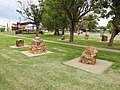
Poets Corner of Central Park (2021).

Oxley Street town centre (2021).
Australia Post office (2021).
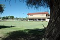
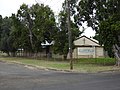
Bourke Bowls Club on a Sunday morning
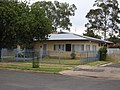
Country Women's Association rest room (2021).
M A Davidson Memorial Sports Ground (2021).

War memorial (2021).

Fire station (2021).

Bourke District Hospital, Tarcoon Street (2021).

NSW Police Force police station (2021).

NSW Police local area command (2021).
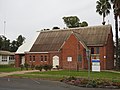
Anglican church (2021).
Bourke Christian Church (2021).
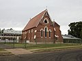
Catholic church (2021).

Mosque in Bourke cemetery. 19th-century Bourke was home to many Afghan camel keepers
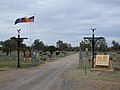
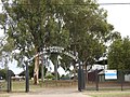
Town cemetery, Gorrell Avenue/Kidman Way (2021).

Headstones of the old section of the Bourke Cemetery, Gorrell Avenue (2021).

Old North Bourke Bridge, opened in 1883 (2014).

Lifting span of the old North Bourke Bridge.

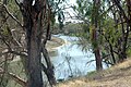
Old North Bourke bridge, in flood, northern side, North Bourke (2021).

Old North Bourke bridge, in flood, southern side, North Bourke (2021).
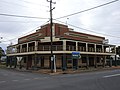
Bourke Cellars, the former Shakespeare Hotel, Mitchell and Glen Streets (2021).

Carriers Arms Hotel, then the Cobb and Co. Tavern, Mitchell and Wilson Streets (2021).
Central Australian Hotel, Anson Street (2021).

Oxford Hotel, Anson Street (2021).

Port Bourke Hotel, Mitchell Street (2021).

Post Office Hotel (2021).
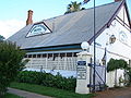
Telegraph Hotel established 1875, now Riverside Motel

Cotton fields between Toorale National Park and North Bourke (2021).


See also[]
- List of disasters in Australia by death toll for the 1895–1896 heat wave that killed 47 in Bourke
References[]
- ^ Jump up to: a b Australian Bureau of Statistics (27 June 2017). "Bourke (Urban Centre/Locality)". 2016 Census QuickStats. Retrieved 15 July 2018.

- ^ Bourke Shire Aboriginal Heritage Study (PDF) (Report). Dubbo, NSW: OzArk Environmental & Heritage Management. Bourke Shire Council. January 2019. p. 23.
- ^ Don Fraser for the Engineering Heritage Committee Engineers Australia, Sydney and the Bourke Shire Council (October 2004). "PLAQUING NOMINATION FOR THE 1883 LIFT BRIDGE AT BOURKE N.S.W. AS A NATIONAL ENGINEERING LANDMARK" (PDF).
- ^ "Archived copy". Archived from the original on 6 October 2013. Retrieved 15 January 2014.CS1 maint: archived copy as title (link)
- ^ "Archived copy" (PDF). Archived from the original (PDF) on 2 March 2011. Retrieved 16 December 2010.CS1 maint: archived copy as title (link)
- ^ "Archived copy" (PDF). Archived from the original (PDF) on 16 March 2011. Retrieved 19 December 2010.CS1 maint: archived copy as title (link)
- ^ "St. Ignatius Roman Catholic Church, Convent & Site". New South Wales State Heritage Register. Office of Environment and Heritage. H00603. Retrieved 18 May 2018.
- ^ "Towers Drug Company Building (former)". New South Wales State Heritage Register. Office of Environment and Heritage. H00383. Retrieved 18 May 2018.
- ^ "Bourke Post Office". New South Wales State Heritage Register. Office of Environment and Heritage. H01404. Retrieved 18 May 2018.
- ^ "Bourke Court House". New South Wales State Heritage Register. Office of Environment and Heritage. H00791. Retrieved 18 May 2018.
- ^ "Ardsilla". New South Wales State Heritage Register. Office of Environment and Heritage. H00198. Retrieved 18 May 2018.
- ^ "Old London Bank Building". New South Wales State Heritage Register. Office of Environment and Heritage. H00764. Retrieved 18 May 2018.
- ^ "North Bourke Bridge, Darling River, 1883 | www.engineersaustralia.org.au". portal.engineersaustralia.org.au. Retrieved 26 July 2020.
- ^ "Australia: Climate Extremes" (PDF). Bureau of Meteorology. Australian Government. January 2019. Retrieved 14 September 2019.
- ^ "Monthly climate statistics". Bureau of Meteorology.
- ^ "THE RAILWAY TO BOURKE". The Sydney Morning Herald. National Library of Australia. 29 August 1885. p. 10. Retrieved 9 February 2014.
- ^ "'I don't know how we come back from this': Australia's big dry sucks life from once-proud towns". The Guardian. 13 September 2019. Retrieved 14 September 2019.
- ^ Bourke station. NSWrail.net, accessed 8 September 2009.
- ^ "background_lawson". robynleeburrows.com. Archived from the original on 16 March 2012. Retrieved 15 July 2017.
- ^ "The Fred Hollows Foundation International : Fred in Bourke". hollows.org. Archived from the original on 17 February 2012. Retrieved 15 July 2017.
- ^ "(Bourke Riverside Motel – Australian Outback Accommodation)". bourkeriversidemotel.com. Archived from the original on 5 March 2016. Retrieved 15 July 2017.
- ^ "Bourke implements takeaway alcohol ban". Australian Broadcasting Corporation. 6 February 2009. Retrieved 15 February 2019.
- ^ Bourke bans the booze Archived 28 October 2009 at the Wayback Machine, The Land 8 December 2008.
- ^ "Backing Bourke". Four Corners. 19 September 2016.
External links[]
![]() Media related to Bourke, New South Wales at Wikimedia Commons
Media related to Bourke, New South Wales at Wikimedia Commons
| Wikisource has the text of the 1911 Encyclopædia Britannica article Bourke. |
- Bourke Shire Council website
- Bourke Tourism Information website
- Bourke and district tourist attractions
- 2WEB – "The Voice of the Outback" – community radio station
Coordinates: 30°6′0″S 145°56′0″E / 30.10000°S 145.93333°E

| show Authority control |
|---|
- Towns in New South Wales
- Bourke, New South Wales
- Populated places on the Darling River
- River ports of Australia
- Far West (New South Wales)
- Bourke Shire