Boxmeer
Boxmeer | |
|---|---|
Municipality | |
 Former Boxmeer city hall (until 2010) | |
 Flag Coat of arms | |
 Location in North Brabant | |
| Coordinates: 51°39′N 5°57′E / 51.650°N 5.950°ECoordinates: 51°39′N 5°57′E / 51.650°N 5.950°E | |
| Country | Netherlands |
| Province | North Brabant |
| Government | |
| • Body | Municipal council |
| • Mayor | (VVD) |
| Area | |
| • Total | 113.84 km2 (43.95 sq mi) |
| • Land | 111.44 km2 (43.03 sq mi) |
| • Water | 2.40 km2 (0.93 sq mi) |
| Elevation | 13 m (43 ft) |
| Population (January 2019)[4] | |
| • Total | 29,065 |
| • Density | 261/km2 (680/sq mi) |
| Demonym(s) | Boxmeerenaar |
| Time zone | UTC+1 (CET) |
| • Summer (DST) | UTC+2 (CEST) |
| Postcode | 5440–5441, 5447, 5820–5836 |
| Area code | 0478, 0485 |
| Website | www |


Station Boxmeer
Boxmeer (pronounced [bɔksˈmeːr] (![]() listen)) is a municipality and a town in upper southeastern Netherlands. It incorporates the former municipality of Beugen en Rijkevoort and that of Vierlingsbeek. In Overloon is the Overloon War Museum.
listen)) is a municipality and a town in upper southeastern Netherlands. It incorporates the former municipality of Beugen en Rijkevoort and that of Vierlingsbeek. In Overloon is the Overloon War Museum.
Topography[]

Population centres[]
- Beugen
- Boxmeer
- Groeningen
- Heikant
- Holthees
- Maashees
- Oeffelt
- Overloon
- Rijkevoort
- Sambeek
- Vierlingsbeek
- Vortum-Mullem
Transport[]
Notable people[]

Dionne Stax, 2017
Kika van Es, 2011
- Dr Anna Terruwe (1911 in Vierlingsbeek – 2004) a Catholic psychiatrist who discovered emotional deprivation disorder
- Joannes Gijsen (1932 in Oeffelt – 2013) a Dutch bishop of the Roman Catholic Church, Bishop of Roermond and Reykjavík
- Emile Roemer (born 1962 in Boxmeer) a Dutch politician
- Hugo van der Velden (born 1963 in Boxmeer) a Dutch art historian
- Charles Deenen (born 1970 in Holthees) a Dutch computer/video game audio director, music composer, sound designer and mixer
- Dionne Stax (born 1985 in Boxmeer) a Dutch journalist and newsreader
Sport[]
- Sjaak Lucassen (born 1961 in Maashees) a Dutch long-distance motorcycle rider
- Niels Fleuren (born 1986 in Boxmeer) a Dutch professional footballer with 420 club caps
- Sander de Wijn (born 1990 in Boxmeer) a Dutch field hockey player, silver medallist at the 2012 Summer Olympics
- Kika van Es (born 1991 in Boxmeer) a Dutch football defender
Gallery[]

Overzicht van de voorgevel - Boxmeer
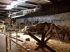
Diorama Invasion 1944, Overloon War Museum

Overloon - Dromedaris met tankkoepelbult van Marjolijn Mandersloot op de hoek van de Museumlaan en de Venraijseweg

Vierlingsbeek, Sint Laurentiuskerk

Canal boats, Groeningen


References[]
- ^ "Samenstelling College van B&W" [Members board of mayor and aldermen] (in Dutch). Gemeente Boxmeer. Archived from the original on 6 May 2014. Retrieved 6 May 2014.
- ^ "Kerncijfers wijken en buurten 2020" [Key figures for neighbourhoods 2020]. StatLine (in Dutch). CBS. 24 July 2020. Retrieved 19 September 2020.
- ^ "Postcodetool for 5831JX". Actueel Hoogtebestand Nederland (in Dutch). Het Waterschapshuis. Retrieved 6 May 2014.
- ^ "Bevolkingsontwikkeling; regio per maand" [Population growth; regions per month]. CBS Statline (in Dutch). CBS. 1 January 2019. Retrieved 1 January 2019.
External links[]
 Media related to Boxmeer at Wikimedia Commons
- Official website
| show Places adjacent to Boxmeer |
|---|
| show Municipalities of North Brabant |
|---|

| Authority control |
|
|---|
This North Brabant location article is a stub. You can help Wikipedia by . |
Categories:
- Boxmeer
- Municipalities of North Brabant
- Populated places in North Brabant
- North Brabant geography stubs