Brallo di Pregola
Brallo di Pregola | |
|---|---|
| Comune di Brallo di Pregola | |
 Village church of Pregola | |
 Brallo di Pregola within the Province of Pavia | |
Location of Brallo di Pregola  | |
 Brallo di Pregola Location of Brallo di Pregola in Italy | |
| Coordinates: 44°44′N 9°17′E / 44.733°N 9.283°ECoordinates: 44°44′N 9°17′E / 44.733°N 9.283°E | |
| Country | Italy |
| Region | Lombardy |
| Province | Pavia (PV) |
| Area | |
| • Total | 46.3 km2 (17.9 sq mi) |
| Elevation | 951 m (3,120 ft) |
| Population (Dec. 2004)[2] | |
| • Total | 832 |
| • Density | 18/km2 (47/sq mi) |
| Demonym(s) | Brallesi |
| Time zone | UTC+1 (CET) |
| • Summer (DST) | UTC+2 (CEST) |
| Postal code | 27050 |
| Dialing code | 0383 |


Brallo di Pregola is a comune (municipality) in the Province of Pavia in the Italian region Lombardy, located about 80 km south of Milan and about 50 km south of Pavia. As of 31 December 2004, it had a population of 832 and an area of 46.3 km².[3]
Geography[]
Located in the Oltrepò Pavese, at the borders of Lombardy with Emilia-Romagna, Brallo di Pregola borders the municipalities of Bobbio (PC), Cerignale (PC), Corte Brugnatella (PC), Santa Margherita di Staffora and Zerba (PC).
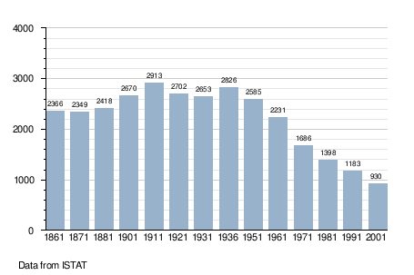
Demographics[]
References[]
- ^ "Superficie di Comuni Province e Regioni italiane al 9 ottobre 2011". Italian National Institute of Statistics. Retrieved 16 March 2019.
- ^ "Popolazione Residente al 1° Gennaio 2018". Italian National Institute of Statistics. Retrieved 16 March 2019.
- ^ All demographics and other statistics: Italian statistical institute Istat.
External links[]
![]() Media related to Brallo di Pregola at Wikimedia Commons
Media related to Brallo di Pregola at Wikimedia Commons
This article on a location in the Province of Pavia is a stub. You can help Wikipedia by . |
Categories:
- Cities and towns in Lombardy
- Municipalities of the Province of Pavia
- Province of Pavia geography stubs