Zavattarello
Zavattarello | |
|---|---|
| Comune di Zavattarello | |
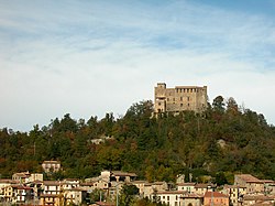 View of Zavattarello Castle | |
Location of Zavattarello  | |
 Zavattarello Location of Zavattarello in Italy | |
| Coordinates: 44°52′N 9°16′E / 44.867°N 9.267°ECoordinates: 44°52′N 9°16′E / 44.867°N 9.267°E | |
| Country | Italy |
| Region | Lombardy |
| Province | Pavia (PV) |
| Government | |
| • Mayor | Simone Tiglio |
| Area | |
| • Total | 28.4 km2 (11.0 sq mi) |
| Elevation | 600 m (2,000 ft) |
| Population (31 December 2015)[3] | |
| • Total | 991 |
| • Density | 35/km2 (90/sq mi) |
| Demonym(s) | Zavattarellesi |
| Time zone | UTC+1 (CET) |
| • Summer (DST) | UTC+2 (CEST) |
| Postal code | 27059 |
| Dialing code | 0383 |
| Website | Official website |


Zavattarello is a comune (municipality) in the Province of Pavia in the Italian region Lombardy, located about 70 km south of Milan and about 35 km south of Pavia.
Zavattarello borders the following municipalities: Alta Val Tidone, Menconico, Romagnese, Ruino, Valverde, Varzi.
The main sights is the castle, also known as Castello Del Verme, which overlooks the town. It once housed the war school of Italian Renaissance condottiero Jacopo Dal Verme.
References[]
- ^ "Superficie di Comuni Province e Regioni italiane al 9 ottobre 2011". Italian National Institute of Statistics. Retrieved 16 March 2019.
- ^ "Popolazione Residente al 1° Gennaio 2018". Italian National Institute of Statistics. Retrieved 16 March 2019.
- ^ All demographics and other statistics: Italian statistical institute Istat.
This article on a location in the Province of Pavia is a stub. You can help Wikipedia by . |
Categories:
- Cities and towns in Lombardy
- Municipalities of the Province of Pavia
- Province of Pavia geography stubs