Bridgeport, Ohio
Bridgeport, Ohio | |
|---|---|
| Nickname(s): "Gateway to the West" | |
 Location of Bridgeport, Ohio | |
 Location of Bridgeport in Belmont County | |
| Coordinates: 40°4′20″N 80°44′37″W / 40.07222°N 80.74361°WCoordinates: 40°4′20″N 80°44′37″W / 40.07222°N 80.74361°W | |
| Country | United States |
| State | Ohio |
| County | Belmont |
| Township | Pease |
| Government | |
| • Type | Statutory Village |
| • Mayor | David W. Smith |
| Area | |
| • Total | 1.38 sq mi (3.56 km2) |
| • Land | 1.37 sq mi (3.54 km2) |
| • Water | 0.01 sq mi (0.03 km2) |
| Elevation | 656 ft (200 m) |
| Population | |
| • Total | 1,831 |
| • Estimate (2019)[5] | 1,728 |
| • Density | 1,265.01/sq mi (488.27/km2) |
| Time zone | UTC-5 (Eastern (EST)) |
| • Summer (DST) | UTC-4 (EDT) |
| ZIP code | 43912 |
| Area code(s) | 740 |
| FIPS code | 39-08560[4] |
| GNIS feature ID | 1064487[2] |

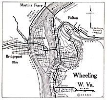
Bridgeport is a village in Belmont County, Ohio, United States. It lies across the Ohio River from Wheeling, West Virginia, and is connected by two bridges to Wheeling Island. The population was 1,831 at the 2010 census.
History[]
Bridgeport was originally known as Canton, and under the latter name was laid out in 1806 by Colonel Ebenezer Zane.[6] The present name is for a bridge constructed near the town site in the 1810s.[7]
Geography[]
Bridgeport is located at 40°4′20″N 80°44′37″W / 40.07222°N 80.74361°W (40.072092, −80.743542),[8] along the Ohio River at the mouth of Wheeling Creek.[9]
According to the United States Census Bureau, the village has a total area of 1.38 square miles (3.57 km2), of which 1.37 square miles (3.55 km2) is land and 0.01 square miles (0.03 km2) is water.[10]
Demographics[]
| Historical population | |||
|---|---|---|---|
| Census | Pop. | %± | |
| 1830 | 169 | — | |
| 1840 | 329 | 94.7% | |
| 1860 | 641 | — | |
| 1870 | 1,178 | 83.8% | |
| 1880 | 2,395 | 103.3% | |
| 1890 | 3,369 | 40.7% | |
| 1900 | 3,963 | 17.6% | |
| 1910 | 3,974 | 0.3% | |
| 1920 | 3,977 | 0.1% | |
| 1930 | 4,655 | 17.0% | |
| 1940 | 4,853 | 4.3% | |
| 1950 | 4,309 | −11.2% | |
| 1960 | 3,824 | −11.3% | |
| 1970 | 3,001 | −21.5% | |
| 1980 | 2,642 | −12.0% | |
| 1990 | 2,318 | −12.3% | |
| 2000 | 2,186 | −5.7% | |
| 2010 | 1,831 | −16.2% | |
| 2019 (est.) | 1,728 | [5] | −5.6% |
| U.S. Decennial Census[11] | |||
2000 census[]
As of the census[4] of 2000, there were 2,186 people, 973 households, and 586 families living in the village. The population density was 1,569.0 people per square mile (607.2/km2). There were 1,090 housing units at an average density of 782.3 per square mile (302.8/km2). The racial makeup of the village was 90.81% White, 7.55% African American, 0.14% Native American, 0.14% Asian, 0.55% from other races, and 0.82% from two or more races. Hispanic or Latino of any race were 0.50% of the population.

There were 973 households, out of which 26.9% had children under the age of 18 living with them, 42.0% were married couples living together, 13.7% had a female householder with no husband present, and 39.7% were non-families. 36.1% of all households were made up of individuals, and 15.8% had someone living alone who was 65 years of age or older. The average household size was 2.24 and the average family size was 2.89.
In the village, the population was spread out, with 23.2% under the age of 18, 6.2% from 18 to 24, 29.0% from 25 to 44, 24.5% from 45 to 64, and 17.1% who were 65 years of age or older. The median age was 40 years. For every 100 females, there were 88.9 males. For every 100 females age 18 and over, there were 85.4 males.
The median income for a household in the village was $25,685, and the median income for a family was $33,231. Males had a median income of $24,156 versus $18,333 for females. The per capita income for the village was $14,723. About 11.5% of families and 16.2% of the population were below the poverty line, including 19.1% of those under age 18 and 7.3% of those age 65 or over.
2010 census[]
As of the census[3] of 2010, there were 1,831 people, 810 households, and 472 families living in the village. The population density was 1,336.5 inhabitants per square mile (516.0/km2). There were 943 housing units at an average density of 688.3 per square mile (265.8/km2). The racial makeup of the village was 89.7% White, 6.9% African American, 0.2% Asian, 0.2% from other races, and 3.0% from two or more races. Hispanic or Latino of any race were 0.2% of the population.
There were 810 households, of which 25.4% had children under the age of 18 living with them, 40.2% were married couples living together, 13.3% had a female householder with no husband present, 4.7% had a male householder with no wife present, and 41.7% were non-families. 35.6% of all households were made up of individuals, and 14.9% had someone living alone who was 65 years of age or older. The average household size was 2.26 and the average family size was 2.91.
The median age in the village was 43.3 years. 19.5% of residents were under the age of 18; 9% were between the ages of 18 and 24; 23.5% were from 25 to 44; 30.7% were from 45 to 64; and 17.4% were 65 years of age or older. The gender makeup of the village was 48.8% male and 51.2% female.
Climate[]
| hideClimate data for Bridgeport, Ohio | |||||||||||||
|---|---|---|---|---|---|---|---|---|---|---|---|---|---|
| Month | Jan | Feb | Mar | Apr | May | Jun | Jul | Aug | Sep | Oct | Nov | Dec | Year |
| Record high °F (°C) | 73 (23) |
78 (26) |
84 (29) |
90 (32) |
92 (33) |
98 (37) |
103 (39) |
98 (37) |
95 (35) |
88 (31) |
81 (27) |
73 (23) |
103 (39) |
| Average high °F (°C) | 38 (3) |
42 (6) |
51 (11) |
63 (17) |
73 (23) |
82 (28) |
85 (29) |
84 (29) |
77 (25) |
66 (19) |
54 (12) |
42 (6) |
63 (17) |
| Average low °F (°C) | 21 (−6) |
23 (−5) |
31 (−1) |
39 (4) |
50 (10) |
59 (15) |
64 (18) |
63 (17) |
56 (13) |
43 (6) |
35 (2) |
27 (−3) |
43 (6) |
| Record low °F (°C) | −16 (−27) |
−3 (−19) |
5 (−15) |
20 (−7) |
33 (1) |
41 (5) |
49 (9) |
50 (10) |
37 (3) |
26 (−3) |
15 (−9) |
−10 (−23) |
−16 (−27) |
| Average precipitation inches (mm) | 2.71 (69) |
2.53 (64) |
3.46 (88) |
3.02 (77) |
4.35 (110) |
3.82 (97) |
4.92 (125) |
3.59 (91) |
3.31 (84) |
2.16 (55) |
3.32 (84) |
3.15 (80) |
40.34 (1,024) |
| Average snowfall inches (cm) | 7.2 (18) |
4.2 (11) |
3.8 (9.7) |
1.6 (4.1) |
0 (0) |
0 (0) |
0 (0) |
0 (0) |
0 (0) |
0.1 (0.25) |
0.9 (2.3) |
3.4 (8.6) |
21.2 (53.95) |
| Source: [12] | |||||||||||||
Education[]
Bridgeport has a public library, a branch of the Belmont County District Library.[13]
Notable people[]
- Johnny Blatnik, former professional baseball player
- Bobby Douglas, Olympic wrestler
- John Havlicek, Hall of Fame basketball player for Ohio State and Boston Celtics
- Bill Jobko, National Football League football player
- Joseph Henry Sharp, painter
- Thomas Clarke Theaker, Republican U.S. Representative from Ohio
- Bill White, Major League Baseball player
- John Todd Zimmer, leading ornithologist
See also[]
- List of cities and towns along the Ohio River
References[]
- ^ "2019 U.S. Gazetteer Files". United States Census Bureau. Retrieved July 27, 2020.
- ^ Jump up to: a b "US Board on Geographic Names". United States Geological Survey. 2007-10-25. Retrieved 2008-01-31.
- ^ Jump up to: a b "U.S. Census website". United States Census Bureau. Retrieved 6 January 2013.
- ^ Jump up to: a b "U.S. Census website". United States Census Bureau. Retrieved 2008-01-31.
- ^ Jump up to: a b "Population and Housing Unit Estimates". Retrieved May 21, 2020.
- ^ McKelvey, A. T. (1903). Centennial History of Belmont County, Ohio, and Representative Citizens. Biographical Publishing Company. pp. 203–204.
- ^ Overman, William Daniel (1958). Ohio Town Names. Akron, OH: Atlantic Press. p. 18.
- ^ "US Gazetteer files: 2010, 2000, and 1990". United States Census Bureau. 2011-02-12. Retrieved 2011-04-23.
- ^ Ohio Atlas & Gazetteer. Yarmouth, Me.: DeLorme. 1991. pp. 62–63. ISBN 0-89933-233-1.
- ^ "US Gazetteer files 2010". United States Census Bureau. Archived from the original on 24 January 2012. Retrieved 6 January 2013.
- ^ "Census of Population and Housing". Census.gov. Retrieved June 4, 2015.
- ^ [1]
- ^ "Locations & Hours". Belmont County District Library. Retrieved 25 February 2018.
External links[]
| show Municipalities and communities of Belmont County, Ohio, United States |
|---|

| show Authority control |
|---|
- Villages in Belmont County, Ohio
- Villages in Ohio
- Ohio populated places on the Ohio River
- 1806 establishments in Ohio