Burnt Oak tube station
| Burnt Oak | |
|---|---|
 | |
 Burnt Oak Location of Burnt Oak in Greater London | |
| Location | Burnt Oak |
| Local authority | London Borough of Barnet |
| Managed by | London Underground |
| Number of platforms | 2 |
| Fare zone | 4 |
| London Underground annual entry and exit | |
| 2015 | |
| 2016 | |
| 2017 | |
| 2018 | |
| 2019 | |
| Railway companies | |
| Original company | London Electric Railway |
| Key dates | |
| 27 October 1924 | Opened as Burnt Oak |
| c. 1928 | Renamed Burnt Oak (Watling) |
| c. 1950 | Renamed Burnt Oak |
| Other information | |
| External links | |
| WGS84 | 51°36′10″N 0°15′50″W / 51.60278°N 0.26389°WCoordinates: 51°36′10″N 0°15′50″W / 51.60278°N 0.26389°W |

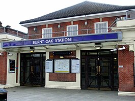
Burnt Oak is a London Underground station in Burnt Oak, north London, on Watling Avenue, off the A5 (the Edgware Road, originally a Roman Road known as Watling Street). The station is on the Edgware branch of the Northern line, between Edgware and Colindale stations, and in Travelcard Zone 4.
Location[]
Burnt Oak is on Watling Avenue, situated near the Burnt Oak Library, separated by the rail tracks. The station serves a moderate residential area. Rows of shops are along Watling Avenue. Barnfield Primary School, Burnt Oak Brook, Goldbeaters Primary School, Barnet Burnt Oak Leisure Center and Edgware Community Hospital are nearby.[4]
History[]
The station was designed by architect Stanley Heaps and opened as Burnt Oak (for Watling)[citation needed] on 27 October 1924, two months after the extension of the Hampstead & Highgate Line from Hendon Central to Edgware had opened. For a while, the station was going to be named "Sheves Hill", and this name appears on a version of the Underground map from 1924. On a later version "Sheves Hill" is crossed out with "Burnt Oak" printed on the side. The station was originally provided with a temporary structure before the final ticket office building was constructed in 1925. The suffix was dropped from the name about 1950.
In 2018, it was announced that the station would gain step free access by 2022, as part of a £200m investment to increase the number of accessible stations on the Tube.[5]
Services and connections[]
The station is on the London Underground Northern line, between Edgware and Colindale stations, in Zone 4. The typical off-peak service, in trains per hour (tph) is:[6]
- 10 tph northbound to Edgware
- 10 tph southbound to Morden via Bank or Kennington via Charing Cross
London Buses routes 32, 114, 142, 204, 251, 292, 302, 614 and 644, and night routes N5 and N16 serve the station.
Gallery[]

View SE, towards Golders Green and central London in 1961

Island platform looking north

Island platform looking south
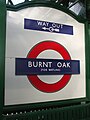
One of the larger roundels displaying the former suffix "for Watling"


References[]
- ^ Jump up to: a b c "Multi-year station entry-and-exit figures (2007–2017)" (XLSX). London Underground station passenger usage data. Transport for London. January 2018. Retrieved 22 July 2018.
- ^ "Station Usage Data" (CSV). Usage Statistics for London Stations, 2018. Transport for London. 21 August 2019. Retrieved 27 April 2020.
- ^ "Station Usage Data" (XLSX). Usage Statistics for London Stations, 2019. Transport for London. 23 September 2020. Retrieved 9 November 2020.
- ^ "Burnt Oak tube station" (Map). Google Maps. Retrieved 6 February 2019.
- ^ "Huge boost for accessibility as further 13 stations to go step-free". London City Hall. 19 January 2018. Retrieved 2 February 2018.
- ^ Feather, Clive (18 September 2018). "Northern line". Clive's Underground Line Guides. Archived from the original on 4 February 2019. Retrieved 4 February 2019.
External links[]
| Wikimedia Commons has media related to Burnt Oak tube station. |
- Rail transport stations in London fare zone 4
- Northern line stations
- Tube stations in the London Borough of Barnet
- Former London Electric Railway stations
- Railway stations in Great Britain opened in 1924
- London Underground Night Tube stations
- Stanley Heaps railway stations