California State Route 140
 | ||||
|---|---|---|---|---|
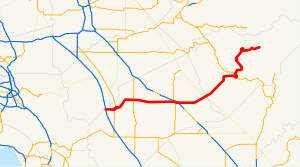 SR 140 highlighted in red | ||||
| Route information | ||||
| Maintained by Caltrans | ||||
| Length | 101.645 mi[1] (163.582 km) SR 140 is broken into pieces, and the length does not reflect the overlaps that would be required to make the route continuous. | |||
| Tourist routes | ||||
| Major junctions | ||||
| West end | ||||
| East end | Yosemite National Park | |||
| Location | ||||
| Counties | Merced, Mariposa | |||
| Highway system | ||||
| ||||
State Route 140 (SR 140) is a state highway in the U.S. state of California, 102 miles (164 km) in length. It begins in the San Joaquin Valley at Interstate 5 near Gustine, and runs east into Sierra Nevada, terminating in Yosemite National Park.
Route description[]


Heading east from I-5, the highway passes Gustine; it then jogs to cross the San Joaquin River. It roughly marks the southern edge of the farmable land around Livingston. It intersects with State Route 99 in Merced, which it overlaps for a few miles. Travelers coming from most regions of the San Francisco Bay Area or other parts of Northern California to Yosemite Valley and the southern portion of Yosemite would transfer from Highway 99 to Highway 140 at this point. For those coming from San Jose and the rest of the Silicon Valley, the most direct, fastest route is State Route 152 east; then the roads of Road 9, Bliss Road, Sandy Mush Road, and Plainsburg Road to reach Highway 140 in Planada. (Those going to the northern portion of Yosemite would have instead taken either I-580 and I-205 leaving the Bay Area, then State Route 120 east through Manteca, or State Route 132 east through Modesto.)
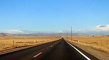
After exiting Highway 99, Highway 140 continues through Planada, after which the farmland gives way to grazing land. It is quite dry in the summer due to California's Mediterranean climate, and the dry grass gives the landscape a golden color. Western meadowlarks, American kestrels, red-tailed hawks and turkey vultures are frequently glimpsed. A few blue oaks can be seen as the highway leaves the valley and begins to climb through the foothills of the Sierra Nevada. They become more and more numerous as the elevation increases. As the highway passes through Catheys Valley the vegetation begins to diversify a little. California live oaks and ponderosa pines intermingle with the blue oaks as it nears Mariposa. In Mariposa, it briefly runs concurrently with State Route 49.
A ponderosa pine forest borders the highway on both sides as it passes through Midpines. As it approaches Briceburg, the roadway follows a steep, winding grade down to the Merced River valley. The highway then runs alongside the Merced River for 20 miles to the park entrance, after passing through El Portal before finally entering Yosemite Valley, where it ends. The upper stretch of the Merced River valley below the park, which the highway follows, is designated as Wild and Scenic River Area. The area separates Sierra National Forest (south) and Stanislaus National Forest (north).
SR 140 is part of the California Freeway and Expressway System,[3] and is part of the National Highway System,[4] a network of highways that are considered essential to the country's economy, defense, and mobility by the Federal Highway Administration.[5] SR 140 is eligible to be included in the State Scenic Highway System;[6] however, only the part of the road from Mariposa to El Portal is designated as a scenic highway.[7]
History[]
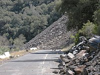
The "All-Weather Highway" (now State Route 140) opened in 1926, ensuring year-long visitation and delivery of supplies under normal conditions.[74] NPS 1989, p. 113. In June 2006, the road between El Portal and Mariposa was closed due to a rock slide. The Ferguson Slide buried about 600 feet (180 m) of SR140 between Cedar Lodge and Briceburg Visitor Center between SR-49 and SR-41.[8]
A small detour opened in August, 2006, with a traffic light system to allow drivers to circumvent the original slide damage area. Plans are underway for construction of a rock shed through the slide area to restore the original alignment.
The road was closed in 2018 due to the Ferguson Fire.
Major intersections[]
Except where prefixed with a letter, postmiles were measured on the road as it was in 1964, based on the alignment that existed at the time, and do not necessarily reflect current mileage. R reflects a realignment in the route since then, M indicates a second realignment, L refers an overlap due to a correction or change, and T indicates postmiles classified as temporary ().[1] Segments that remain unconstructed or have been relinquished to local control may be omitted. The numbers reset at county lines; the start and end postmiles in each county are given in the county column.
| County | Location | Postmile [1][9][10] | Exit [11] | Destinations | Notes |
|---|---|---|---|---|---|
| Merced | | 0.00 | Sullivan Road | Continuation beyond I-5 | |
| | 0.00 | Interchange; west end of SR 140 | |||
| Gustine | 4.35 | West end of SR 33 overlap | |||
| 6.06 | East end of SR 33 overlap | ||||
| | 16.22 | ||||
| | 23.43 | Lincoln Boulevard – Livingston | |||
| | 29.47 | Applegate Road – Atwater | |||
| Merced | 35.81 15.77[N 1] | Interchange; west end of SR 99 / SR 59 overlap | |||
| | West end of freeway on SR 99 | ||||
| 14.69[N 1] | 187B | East end of SR 59 overlap | |||
| 14.41[N 1] | 187A | G Street | Westbound exit and eastbound entrance | ||
| | East end of freeway on SR 99 | ||||
| 13.86[N 1] 35.82 | Interchange; east end of SR 99 overlap | ||||
| Planada | 43.70 | Plainsburg Road – Le Grand, Madera, Fresno | |||
| Mariposa | Catheys Valley | 9.50 | Hornitos Road – Hornitos | ||
| Mariposa | 21.22 | West end of SR 49 overlap | |||
| 22.00 | East end of SR 49 overlap | ||||
| | 51.80 | East end of state maintenance at Yosemite National Park west boundary | |||
| | | ||||
| | | Northside Drive | Entrance only | ||
| | | Eastbound access only | |||
| | | Southside Drive – Yosemite Valley Destinations | Continuation beyond SR 41; westbound entrance only accessible via Northside Drive | ||
1.000 mi = 1.609 km; 1.000 km = 0.621 mi
| |||||
See also[]
 California Roads portal
References[]
- ^ a b c California Department of Transportation. "State Truck Route List". Sacramento: California Department of Transportation. Archived from the original (XLS file) on June 30, 2015. Retrieved June 30, 2015.
- ^ California Department of Transportation (August 2019). "Officially Designated State Scenic Highways and Historic Parkways" (XLSX). Sacramento: California Department of Transportation. Retrieved March 27, 2019.
- ^ "Article 2 of Chapter 2 of Division 1". California Streets and Highways Code. Sacramento: California Office of Legislative Counsel. Retrieved February 6, 2019.
- ^ Federal Highway Administration (March 25, 2015). National Highway System: California (North) (PDF) (Map). Scale not given. Washington, DC: Federal Highway Administration. Retrieved September 27, 2017.
- ^ Natzke, Stefan; Neathery, Mike & Adderly, Kevin (June 20, 2012). "What is the National Highway System?". National Highway System. Washington, DC: Federal Highway Administration. Retrieved July 1, 2012.
- ^ "Article 2.5 of Chapter 2 of Division 1". California Streets & Highways Code. Sacramento: California Office of Legislative Counsel. Retrieved February 6, 2019.
- ^ California Department of Transportation (August 2019). "Officially Designated State Scenic Highways and Historic Parkways" (XLSX). Sacramento: California Department of Transportation. Retrieved September 27, 2017.
- ^ "Ferguson Rock Slide" (PDF). Archived from the original (PDF) on August 10, 2006.
- ^ California Department of Transportation (July 2007). "Log of Bridges on State Highways". Sacramento: California Department of Transportation.
- ^ California Department of Transportation, All Traffic Volumes on CSHS, 2005 and 2006
- ^ California Department of Transportation, California Numbered Exit Uniform System, State Route 99 Freeway Interchanges, Retrieved on 2009-02-14.
External links[]
| Wikimedia Commons has media related to California State Route 140. |
Route map:

| ( • help)
|
- Caltrans Route 140 Photos
- California Highways—State Route 140
- California @ AARoads.com - State Route 140
- Caltrans: Route 140 highway conditions
- Acrobat US Forest Service file containing a map of the slide, (June 2006).
- Current Conditions - Ferguson Rock Slide, Chronology of Events
| Attractions |
| |||||
|---|---|---|---|---|---|---|
| People |
| |||||
| Lodging & camping |
| |||||
| Natural disasters | ||||||
| Transportation | ||||||
| Nearby municipalities | ||||||
| Additional information |
| |||||

- State highways in California
- Roads in Merced County, California
- State Scenic Highway System (California)
- Roads in Mariposa County, California
- Merced, California