Camboulit
Camboulit | |
|---|---|
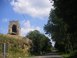 The ruins of the Chapelle St Martin in Camboulit | |
show Location of Camboulit | |
 Camboulit | |
| Coordinates: 44°36′03″N 1°57′02″E / 44.6008°N 1.9506°ECoordinates: 44°36′03″N 1°57′02″E / 44.6008°N 1.9506°E | |
| Country | France |
| Region | Occitanie |
| Department | Lot |
| Arrondissement | Figeac |
| Canton | Figeac-1 |
| Intercommunality | CC Grand-Figeac |
| Government | |
| • Mayor (2020–2026) | Jean-Claude Voynet[1] |
| Area 1 | 5.19 km2 (2.00 sq mi) |
| Population (Jan. 2018)[2] | 257 |
| • Density | 50/km2 (130/sq mi) |
| Time zone | UTC+01:00 (CET) |
| • Summer (DST) | UTC+02:00 (CEST) |
| INSEE/Postal code | 46052 /46100 |
| Elevation | 177–312 m (581–1,024 ft) (avg. 232 m or 761 ft) |
| 1 French Land Register data, which excludes lakes, ponds, glaciers > 1 km2 (0.386 sq mi or 247 acres) and river estuaries. | |


Camboulit is a commune in the Lot department in south-western France.
See also[]
- Communes of the Lot department
References[]
- ^ "Répertoire national des élus: les maires". data.gouv.fr, Plateforme ouverte des données publiques françaises (in French). 2 December 2020. Retrieved 7 December 2020.
- ^ "Populations légales 2018". INSEE. 28 December 2020.
| Wikimedia Commons has media related to Camboulit. |
| show Communes of the Lot department |
|---|
This Lot geographical article is a stub. You can help Wikipedia by . |
Categories:
- Communes of Lot (department)
- Lot (department) geography stubs