Campanian Ignimbrite eruption
| Campanian Ignimbrite eruption | |
|---|---|
 | |
| Volcano | Phlegraean Fields |
| Date | 37,330 BCE |
| Type | Ultra-Plinian |
| Location | Naples, Campania, Italy 40°49′37″N 14°08′20″E / 40.827°N 14.139°ECoordinates: 40°49′37″N 14°08′20″E / 40.827°N 14.139°E |
| VEI | 7 |
 Phlegraean Fields Location of eruption | |
The Campanian Ignimbrite eruption (CI, also CI Super-eruption) was a major volcanic eruption in the Mediterranean during the late Quaternary, classified 7 on the Volcanic Explosivity Index (VEI).[1][2] The event has been attributed to the Archiflegreo volcano, the 13-kilometre-wide (8.1 mi) caldera of the Phlegraean Fields, located 20 km (12 mi) west of Mount Vesuvius under the western outskirts of the city of Naples and the Gulf of Pozzuoli, Italy.[3] Estimates of the date and magnitude of the eruption(s), and the amount of ejected material have varied considerably during several centuries the site has been studied. This applies to most significant volcanic events that originated in the Campanian Plain, as it is one of the most complex volcanic structures in the world. However, continued research, advancing methods, and accumulation of volcanological, geochronological, and geochemical data have improved the dates' accuracy.[4]
The most recent dating determines the eruption event at 39280±110 years BP[5] and results of 3‑D ash dispersion modelling published in 2012[6] concluded a dense-rock equivalent (DRE) of 181–265 km3 (43–64 cu mi)[1] and emissions dispersed over an area of around 3,700,000 km2 (1,400,000 sq mi). The accuracy of these numbers is of significance for marine geologists, climatologists, palaeontologists, paleo-anthropologists and researchers of related fields as the event coincides with a number of global and local phenomena, such as widespread discontinuities in archaeological sequences, climatic oscillations and biocultural modifications.[7]
Etymology[]
The term Campanian refers to the Campanian volcanic arc located mostly but not exclusively in the region of Campania in southern Italy that stretches over a subduction zone created by the convergence of the African and Eurasian plates.[8] It should not be confused with the Late Cretaceous stage Campanian.
The word ignimbrite was coined by New Zealand geologist Patrick Marshall from Latin ignis (fire) and imber (shower)) and -ite. It means the deposits that form as a result of a pyroclastic eruption.[9]
Background[]

The Phlegraean Fields (Italian: Campi Flegrei "burning fields"[a])[10] caldera is a nested structure with a diameter of around 13 km (8.1 mi).[11] It is composed of the older Campanian Ignimbrite caldera, the younger Neapolitan Yellow Tuff caldera and widely scattered sub-aerial and submarine vents from which the most recent eruptions have originated. The Fields sit upon a Pliocene – Quaternary Extensional domain with faults, that run North-East to South-West and North-West to South-East from the margin of the Apennine thrust belt. The sequence of deformation has been subdivided into three periods.[12]
Phlegraean Periods[]
- The First Period, which includes the Campanian Ignimbrite Eruption, was the most decisive era in the Phlegraean Fields' geologic history. Beginning more than 40,000 years ago as the external caldera formed, subsequent caldera collapses and repeated volcanic activity took place within a limited area.[13]
- During the Second Period, the smaller Neapolitan Yellow Tuff eruption (Neapolitan Yellow Tuff or NYT) took place around 15,000 years ago.
- Eruptions of the Third Period occurred during three intervals between 15,000–9,500 years ago, 8,600–8,200 years ago and from 4,800 to 3,800 years ago.[14]
The structure's magma chamber remains active as there apparently are solfataras, hot springs, gas emissions and frequent episodes of large-scale up- and downlift ground deformation (Bradyseism) do occur.[15][16]
In 2008 it was discovered that the Phlegraean Fields and Mount Vesuvius have a common magma chamber at a depth of 10 km (6.2 mi).[17]
The region's volcanic nature has been recognized since Antiquity, investigated and studied for many centuries. Methodical scientific research began in the late 19th century. The yellow tuff stone was extensively quarried for centuries, which left large underground cavities that served as aqueducts and cisterns for the collection of rain water.[18]
In 2016 Italian Volcanologists announced plans to drill a probe 3 km (1.9 mi) deep into the Phlegraean Fields several years after the 2008 Campi Flegrei Deep Drilling Project which had aimed to drill a 3.5 km (2.2 mi) diagonal borehole in order to bring up rock samples and install seismic equipment. The project was suspended in 2010 due to safety problems.[19]
Eruptive sequence[]
The CI eruption has been interpreted as the largest volcanic eruption of the past 200,000 years in Europe.[20] Tephra deposits indicate two distinct plume forming phases, a Plinian and a co-ignimbrite, characterized by multiple caldera-forming eruptions.[21]
Plinian phase[]
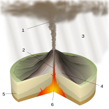
Evidence shows that the eruption was a single event lasting 2 to 4 days.[22] It was triggered by abrupt changes in composition, properties and physical state in the melt or overpressure in the magma chamber. The eruption started with phreatomagmatic explosions, followed by a Plinian eruption column, fed by simultaneous extraction of two magma layers. The resulting ash plume is estimated to have been 70 km (43 mi) high. As gradually an unstable pulsating column formed, fed only by the most evolved magma due to upward migration of the fragmentation surface, reduced magma eruption rate, and/or activation of fractures, the Plinian phase ended. Emissions consisted of pumice and dark colored volcanic rock (scoria). The mafic minerals cover smaller areas than the more acidic members, also indicating a decrease of explosivity over the course of the eruption. The eruption column caused a large pumice-fall deposit to the east of the source area.[23]
Pyroclastic density currents[]
The initial eruption was followed by a caldera collapse and a large pyroclastic flow, fed by the upper magma layer, a single flow unit with lateral variations in both pumice and lithic fragments, that covered an area of 30,000 km2 (12,000 sq mi). Currents that moved toward the North and the South overflowed 1,000-metre-high (3,300 ft) mountain ranges and crossed the Gulf of Naples over the sea, extinguishing all life within a radius of about 100 km (62 mi).[24][25] Textural and morphological features of the deposits, and areal distribution suggests that the eruption was of the type of highly expanded low-temperature pyroclastic cloud.
The pyroclastic sequence from base to top:
- densely welded ignimbrite and lithic-rich breccias
- sintered ignimbrite, low-grade ignimbrite and lithic-rich breccia
- lithic-rich breccia and spatter agglutinate (see Volcanic cone)
- low-grade ignimbrite[26][27]
Ignimbrite deposit[]

The ignimbrite is a gray, poorly to moderately welded, nearly saturated potassic trachyte, similar to many other trachytes of the Quaternary volcanic province of Campania. It consists of pumice and lithic fragments in a devitrified matrix that contains sanidine, lesser plagioclase rimmed by sanidine, two clinopyroxenes, biotite, and magnetite. The column collapse that generated the widespread ignimbrite deposit most likely occurred due to an increase of the Mass Eruption Rate (MER), (see Eruption column).[28]
The immediate area was completely buried by thick layers of pyroclastic fragments, volcanic blocks, lapilli and ash. Two thirds of Campania sank under a layer of tuff as much as 100 m (330 ft) thick. The greater ignimbrite deposit, mostly trachytic ash and pumice, covered an area of at least 6,095 km2 (2,353 sq mi),[1] encompassing most of the southern Italian peninsula and the eastern Mediterranean region.[29][30]
Calculations of ash thickness measurements collected at 115 sites and a three dimensional ash dispersal model add up to a total amount of fallout material of 300 km3 of tephra across an area of 3,700,000 km2 (1,400,000 sq mi). Considering volume estimations of up to 300 km3 (72 cu mi) for the proximal pyroclastic density current deposits, the total bulk volume of the CI eruption is 680 km3 (160 cu mi) covering most of the eastern Mediterranean and ash clouds reaching as far as central Russia.[31][32] A most recent work calculated the volume of the ignimbrite and updated the total eruptive volume to 457–660 km3 (181–265 km3 Dense Rock Equivalent). This volume corresponds to a mass of 4.7–6.9×10¹⁴ kg, to a Richter magnitude of 7.7–7.8 and to a VEI 7.[1]
Global impact[]

The event's recent dating at 39,280±110 years ago draws considerable scholarly attention as it marks a time interval characterized by biocultural modifications in western Eurasia and widespread discontinuities in archaeological sequences, such as the Middle to Upper Palaeolithic transition. At several archaeological sites of South-eastern Europe, the ash separates the cultural layers containing Middle Palaeolithic and/or Earliest Upper Palaeolithic assemblages from the layers in which Upper Palaeolithic industries occur. At some sites the CI tephra deposit coincides with a long interruption of paleo-human occupation.
Effect on climate[]
The climatic importance of the eruption was tested in a three-dimensional sectional aerosol model that simulated the global aerosol cloud under glacial conditions. Black et al. (2015)[33] calculate that up to 450 million kilograms (990 million pounds) of sulphur dioxide would have been accumulated into the atmosphere, driving down temperatures at least by 1–2 degrees Celsius (1.8–3.6 degrees Fahrenheit) for a period of 2–3 years.[33]
Archaeology[]
Many archaeological sites in south-eastern Europe keep evidence of eruption. Kostyonki–Borshchyovo archaeological complex which is about 40,000 years old was found to have a layer of sediment ash.
Effect on living organisms[]
Sulphur dioxide and chloride emissions caused acidic rains, fluorine-laden particles become incorporated into plant matter, potentially inducing dental fluorosis, replete with eye, lung and organ damage in animal populations.[34]
Neanderthal demise[]
The eruption coincided also with the final decline of the Neanderthal in Europe. The environmental stress associated with the CI may have contributed to the extinction of the Neanderthals in combination with societal upheaval in the Paleolithic era. The notion remains contested; nonetheless, sources admit that although the CI would have affected both modern humans and Neanderthals equally, the assumed capacity of modern humans for resilience and ingenuity over and above that of Neanderthals could have allowed modern humans to recover more quickly at Neanderthals' expense.[35][36]
See also[]
Footnotes[]
- ^ The term Campi Flegrei is mixed Latin and ancient Greek, indicating that the volcanic nature of the area has been well known in antiquity.
References[]
- ^ a b c d Silleni, Aurora; Giordano, Guido; Isaia, Roberto; Ort, Michael H. (2020). "The magnitude of the 39.8 ka Campanian Ignimbrite eruption, Italy: Method, uncertainties, and errors". Frontiers in Earth Science. 8. doi:10.3389/feart.2020.543399. ISSN 2296-6463. S2CID 224274557.
- ^ Mastrolorenzo, Giuseppe; Palladino, Danilo M.; Pappalardo, Lucia; Rossano, Sergio (5 March 2016). "Probabilistic-Numerical assessment of pyroclastic current hazard at Campi Flegrei and Naples city: Multi-VEI scenarios as a tool for full-scale risk management – VEI 7 Campanian Ignimbrite extreme event". PLOS ONE. 12 (10): e0185756. arXiv:1603.01747. Bibcode:2017PLoSO..1285756M. doi:10.1371/journal.pone.0185756. PMC 5636126. PMID 29020018.
- ^ "Campi Flegrei (Phlegrean Fields) volcano". Volcano Discovery. Retrieved 5 September 2016.
- ^ de Vivo, B. (2001). "New constraints on the pyroclastic eruptive history of the Campanian volcanic plain (Italy)". Mineralogy and Petrology. 73 (1–3): 47–65. Bibcode:2001MinPe..73...47D. doi:10.1007/s007100170010. S2CID 129762185.
- ^ Fedele, Francesco G.; Giaccio, Biagio; Isaia, Roberto; Orsi, Giovanni (2003). Volcanism and the Earth's atmosphere. Geophysical Monograph Series. Vol. 139. pp. 301–325. doi:10.1029/139GM20. ISBN 978-0-87590-998-1. Retrieved 5 September 2016.
- ^ Costa, A. (28 May 2012). "Quantifying volcanic ash dispersal and impact of the Campanian Ignimbrite super-eruption" (PDF). Geophysical Research Letters. 39 (10): n/a. Bibcode:2012GeoRL..3910310C. doi:10.1029/2012GL051605.
- ^ "Campanian Ignimbrite volcanism, climate, and the final decline of the Neanderthals" (PDF). University of California – Berkeley. Retrieved 20 September 2016.
- ^ "Plate tectonic setting". Geology. Mount Vesuvius. Retrieved 5 September 2016.
- ^ "Marshall, Patrick". Te Ara – the Encyclopedia of New Zealand. New Zealand biography. 30 October 2012. p. 1. Retrieved 23 September 2016.
- ^ "flegreo". Garzanti Linguistica. Retrieved 20 September 2016.
- ^ "Campi Flegrei volcano, Campania". SRV. Retrieved 20 September 2016.
- ^ "Phlegrean Fields, Italy". Volcano World. Oregon State University. Retrieved 20 September 2016.
- ^ "Volcanic risk in Campi Flegrei: Past, present, future". Science on the Net [Scienza in rete]. 3 October 2012. Retrieved 20 September 2016.
- ^ Rybar, J.; Stemberk, J.; Wagner, P., eds. (24–26 June 2002) [1 January 2002]. Landslides. First European Conference on Landslides. Prague, Czech Republic: Routledge (published 2 May 2008). p. 129. ISBN 9789058093936. Retrieved 5 September 2016 – via Google Books.
- ^ "Phlegrean Fields volcano". VolcanoTrek. Retrieved 20 September 2016.
- ^ "Bradyseism in the Flegrea area". UNESCO. Retrieved 20 September 2016.
- ^ "Der unsichtbare Supervulkan". Stuttgarter Zeitung. 19 January 2013. Retrieved 5 September 2016.
- ^ MalKo (21 August 2013). "Naples, the Vesuvius and the Phlegraean Fields". Rivista Hyde Park. Archived from the original on 23 September 2016. Retrieved 20 September 2016.
- ^ "Italian scientists to drill into active supervolcano". Mysterious Universe. 5 September 2016. Retrieved 20 September 2016.
- ^ "Ancient Super-Eruption Larger Than Thought ... about 39,000 years ago, it experienced the largest volcanic eruption that Europe has seen in the last 200,000 years". Live Science. 21 June 2012. Retrieved 24 September 2016.
- ^ Marti, Alejandro; Folch, Arnau; Costa, Antonio; Engwell, Samantha (17 February 2016). "Reconstructing the plinian and co-ignimbrite sources of large volcanic eruptions: A novel approach for the Campanian Ignimbrite". Scientific Reports. Springer Nature. 6: 21220. Bibcode:2016NatSR...621220M. doi:10.1038/srep21220. PMC 4756320. PMID 26883449. Retrieved 20 September 2016.
- ^ "Campi Flegrei". University Roma. Archived from the original on 25 December 2016. Retrieved 20 September 2016.
- ^ Scarpati, Claudio; Perrotta, Annamaria (2016). "Stratigraphy and physical parameters of the Plinian phase of the Campanian Ignimbrite eruption" (PDF). Geological Society of America Bulletin. 128 (7–8): 1147. Bibcode:2016GSAB..128.1147S. doi:10.1130/B31331.1. Retrieved 20 September 2016.[permanent dead link]
- ^ Hoffecker; et al. "From the Bay of Naples to the River Don: the Campanian Ignimbrite eruption and the Middle to Upper Paleolithic transition in Eastern Europe" (PDF). archeo.ru (Press release). Journal of Human Evolution. Retrieved 20 September 2016.[full citation needed]
- ^ Fedele, Francesco G.; Giaccio, Biagio; Isaia, Roberto; Orsi, Giovanni (2002). "Ecosystem impact of the Campanian Ignimbrite eruption in Late Pleistocene Europe". Quaternary Research. 57 (3): 420–424. Bibcode:2002QuRes..57..420F. doi:10.1006/qres.2002.2331. S2CID 129476314. Retrieved 5 September 2016.
- ^ Barberi, F.; Innocenti, F.; Lirer, L.; Munno, R.; Pescatore, T.; Santacroce, R. (1978). "The Campanian Ignimbrite: A major prehistoric eruption in the Neapolitan area (Italy)". Bulletin Volcanologique. 41 (1): 10. Bibcode:1978BVol...41...10B. doi:10.1007/BF02597680. S2CID 129252851.
- ^ Rosi, M.; Vezzoli, L.; Aleotti, P.; de Censi, M. (1996). "Interaction between caldera collapse and eruptive dynamics during the Campanian Ignimbrite eruption, Phlegraean Fields, Italy". Bulletin of Volcanology. 57 (7): 541. Bibcode:1996BVol...57..541R. doi:10.1007/BF00304438. S2CID 128796526.
- ^ "Mobility of a large-volume pyroclastic flow – emplacement of the Campanian Ignimbrite, Italy". Geology / Vulcanology. Santa Barbara, CA: University of California. Retrieved 22 September 2016.[full citation needed]
- ^ Rosi, M.; Vezzoli, L.; Aleotti, P.; de Censi, M. (1996). "Interaction between caldera collapse and eruptive dynamics during the Campanian Ignimbrite eruption, Phlegraean Fields, Italy". Bulletin of Volcanology. 57 (7): 541. Bibcode:1996BVol...57..541R. doi:10.1007/BF00304438. S2CID 128796526.
- ^ "Eine extrem kurze Umpolung des Erdmagnetfeldes, Klimaschwankungen und ein Supervulkan ... vor 39400 Jahren, in den untersuchten Sedimenten dokumentiert. Die Asche dieses Ausbruchs, bei dem etwa 350 Kubik-Kilometer Gestein und Lava ausgeworfen wurden ..." Informationsdienst Wissenschaft e. V. Archaeology and Prehistory (in German). 16 October 2012. Retrieved 5 September 2016.
- ^ Engwell, S.L.; Sparks, R.S.; Carey, S.; Aspinall, W. (2011). "The Campanian Ignimbrite eruption: Inferring eruption characteristics from distal submarine deposits". AGU Fall Meeting Abstracts. 51. American Geophysical Union: V51F–2565. Bibcode:2011AGUFM.V51F2565E.
{{cite journal}}: Cite journal requires|journal=(help) - ^ "Campanian Ignimbrite: Possibly more devastating than previously thought". München, DE: Max Planck Gesellschaft. 20 June 2013. Retrieved 24 September 2016.
- ^ a b Black, Benjamin A.; Neely, Ryan R.; Manga, Michael (11 February 2015). "Campanian Ignimbrite volcanism, climate, and the final decline of the Neanderthals". Geology. 43 (5): 411–414. Bibcode:2015Geo....43..411B. doi:10.1130/G36514.1. OSTI 1512181.
- ^ Schultz, Colin (18 June 2012). "Italian super-eruption larger than thought". Eos Transactions. phys org. 93 (30): 298–299. Bibcode:2012EOSTr..93X.298S. doi:10.1029/2012EO300025. Retrieved 5 September 2016.
- ^ "What are those darned Neanderthals up to now?". Anthropology in Practice. 11 October 2010. Retrieved 20 September 2016.
- ^ "Did a volcanic eruption kill off the Neanderthals?". Science for Writers. 25 March 2015. Retrieved 20 September 2016.
External links[]
- "Supercomputing super eruptions at BSC". Inside HPC. February 2016.
- Fitzsimmons, Kathryn E.; Hambach, Ulrich; Veres, Daniel; Iovita, Radu (17 June 2013). "New data on volcanic ash dispersal and its potential impact ..." PLOS ONE. 8 (6): e65839. doi:10.1371/journal.pone.0065839. PMC 3684589. PMID 23799050.
- Pre-Holocene volcanism
- Campanian volcanic arc
- Pleistocene volcanism
- Pleistocene Europe
- Prehistoric Italy
- History of Campania
- VEI-7 eruptions
- Events that forced the climate
- Volcanic eruptions in Italy
- Plinian eruptions