Cape Fear River
| Cape Fear River Tributary to Atlantic Ocean | |
|---|---|
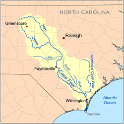 Map of the Cape Fear River drainage basin | |
| Location | |
| Country | United States |
| State | North Carolina |
| County | Bladen Brunswick Chatham Columbus Cumberland Harnett Lee New Hanover Pender |
| City | Lillington Erwin Fayetteville Elizabethtown Wilmington Southport |
| Physical characteristics | |
| Source | confluence of Deep River and Haw River |
| • location | about 1 mile southeast of Moncure, North Carolina |
| • coordinates | 35°35′48″N 079°03′07″W / 35.59667°N 79.05194°W[1] |
| • elevation | 154 ft (47 m)[2] |
| Mouth | Atlantic Ocean |
• location | between Oak Island and Bald Head Island |
• coordinates | 33°53′08″N 078°00′46″W / 33.88556°N 78.01278°WCoordinates: 33°53′08″N 078°00′46″W / 33.88556°N 78.01278°W[1] |
• elevation | 0 ft (0 m)[2] |
| Length | 191.08 mi (307.51 km)[3] |
| Basin size | 9,120.61 square miles (23,622.3 km2)[4] |
| Discharge | |
| • location | Atlantic Ocean |
| • average | 9,959.87 cu ft/s (282.032 m3/s) at mouth with Atlantic Ocean[4] |
| Basin features | |
| Progression | generally southeast |
| River system | Cape Fear River |
| Tributaries | |
| • left | Gulf Creek, Buckhorn Creek, Parkers Creek, Avents Creek, Hector Creek, Neills Creek, Dry Creek, Buies Creek, Thorntons Creek, Juniper Creek, Cedar Creek, Phillips Creek, Harrison Creek, Ellis Creek, Turnbull Creek, Mulford Creek, Bandeau Creek, Frenchs Creek, Black River, Northeast Cape Fear River, Barnards Creek, Mott Creek, Telfairs Creek |
| • right | Wombles Creek, Little Shaddox Creek, Lick Creek, Bush Creek, Fall Creek, Daniels Creek, Cedar Creek, Camels Creek, Little Creek, Fish Creek, Poorhouse Creek, Upper Little River, Little River, Carvers Creek, Cross Creek, Rockfish Creek, Grays Creek, Willis Creek, Georgia Branch, Hucklebrry Swamp, Black Swamp, Bakers Creek, Browns Creek, Pemberton Creek, Hammonds Creek, Drunken Run, Donoho Creek, Carvers Creek, Plummers Run, Steep Run, Weyman Creek, Double Branch, Livingston Creek, Bryant Mill Creek, Grist Mill Branch, Bay Branch, Indian Creek, Cartwheel Branch, Alligator Creek, Brunswick River, Mallory Creek, Little Mallory Creek, Town Creek, Sand Hill Creek, Liliput Creek, Orton Creek, Walden Creek, Price Creek |
| Bridges | Avents Ferry Road, US 401-NC 210, NC 217, I-295, I-95, NC 24-210, I-95, Tarheel Ferry Road, US 701, General Howe Highway (NC 11), US 17-74, US 17 |

The Cape Fear River is a 191.08-mile (307.51 km) long[5] blackwater river in east central North Carolina. It flows into the Atlantic Ocean near Cape Fear, from which it takes its name. The river also has several pollutants, ranging from suspended solids and runoff to manmade chemicals like GenX.
Variant names[]
According to the Geographic Names Information System, it has also been known historically as:[6]
- Cape Fair River
- Cape-Feare River
- Charle River
- Charles River
- Clarendon River
- North East Cape Fear River
- North West Branch
- Rio Jorda
Course[]

It is formed at Haywood, near the county line between Lee and Chatham counties, by the confluence of the Deep and Haw rivers just below Jordan Lake. It flows southeast past Lillington, Fayetteville, and Elizabethtown, then receives the Black River approximately 10 miles (16 km) northwest of Wilmington. At Wilmington, it receives the Northeast Cape Fear River and Brunswick River, turns south, widening as an estuary and entering the Atlantic approximately 3 miles (5 km) west of Cape Fear.
During the colonial era, the river provided a principal transportation route to the interior of North Carolina.[7] Today the river is navigable as far as Fayetteville through a series of locks and dams. The estuary of the river furnishes a segment of the route of the Intracoastal Waterway.
The East Coast Greenway runs along the river.
Bridges[]
- Cape Fear Memorial Bridge (US 17/US 76/US 421)
- S. Thomas Rhodes Bridge (US 421/NC 133/US 74)
- Trooper Harry T. Long Bridge
- L. Bobby Brown Bridge (I-140)
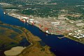
The port in Wilmington on the Cape Fear River estuary
Lock and Dam No. 1 on the Cape Fear River in Bladen County

U.S. Coast Guard vessel on the Cape Fear, photographed from the USS North Carolina

A cargo ship navigating the mouth of the Cape Fear River at Southport

Sunset over the Cape Fear River flowing under the S. Thomas Rhodes Bridge.

Cape Fear Memorial Bridge in Wilmington is the highest in North Carolina.


Pollution[]
Of all the rivers within North Carolina, The Cape Fear River has the largest river basin. It covers 9,149 square miles and, with a basin of this size, there is a large amount of land from which runoff can be produced.[8] Cities and farmland that surround the river and its tributaries have the ability to impact the water quality of the Cape Fear River.[9] The Cape Fear River is negatively impacted by point source and nonpoint sources of pollution. Some examples of nonpoint sources within the Cape Fear River include farms, city runoff, and erosion of the river's banks, which input pollution such as harmful chemicals, and fertilizers, and larger sediments like suspended solids.[8][9][10] As with any river, the water quality varies in different regions and is dependent on specific abiotic and biotic factors within the region.[8]
Suspended Solids[]
Suspended solids refers to any particle (living or nonliving) discharged into an aquatic system that remains in suspension. These particles often find their way into river systems via nonpoint source pollution as well as through larger point source pollution events such as Hurricane Florence In 2018. The stress of this storm led to a dam failure causing a mass leakage of coal ash into the Cape Fear River about five miles northwest of Wilmington, North Carolina.
GenX Chemicals[]
GenX is a chemical in the group of man made per- and polyfluoroalkyl substances, or PFAs. These substances are used for non-stick, water and stain repellent items. GenX is a replacement PFA, since older and more toxic PFAs are being phased out.[11] GenX is made at the Chemours plant in Fayetteville, NC and has gotten into the Cape Fear River from the plant's wastewater.[12] Like other PFAs, GenX does not easily break down and can accumulate in the environment.[11] Because of this quality, GenX can cause problems for both people and wildlife.
Since Chemours’ wastewater was being put into the Cape Fear River, this poses a drinking water issue for residents of the Fayetteville area as well as people further down the river. Several groundwater wells in Fayetteville had detections of GenX.[13] At the mouth of the river, the city of Wilmington uses the Cape Fear as a drinking water source. Blood samples of a group of Wilmington residents showed detections of GenX.[14]
In several studies, GenX has been shown to affect wildlife. PFAs were detected in striped bass caught from the Cape Fear, and the chemical affected the liver and immune system.[15] In plants, GenX reduced the biomass and bioaccumulated in the organism. This bioaccumulation did differ between species.[16]
In a study done to test the ability of retention and how could the GenX chemical be transported in porous materials, results showed that for different forms of the GenX chemical the absorption rate was higher. This research is important to help future researchers understand the tendencies of this chemical. Contaminated sites should be inspected from the water to the soil due to the ability of GenX to travel/transport through porous material such as soil.[17]
The lack of information on the GenX chemical in North Carolina has led to the gap of knowledge about ways in which people may be exposed to these chemicals other than drinking water. Information is also limited on the health effects caused by the GenX chemical, little experiments on animals show liver damage, pancreas damage, etc. There are no federal guidelines regarding the GenX chemical. However, the North Carolina Department of Health and Human Services has set a “health goal”, a non-regulated, and non-enforceable low contamination level where no side effects, over time, would be expected.[18]
There is little known information about the effectiveness of GenX and PFEA removal from contaminated waters, methods like, ozonation and bio-filtration. Carbon in various forms can be used to treat water that has been contaminated. Experiments done with this technique showed that shorter PFAs did not absorb.[19]
See also[]
- List of North Carolina rivers
- USS North Carolina
- Cape Fear Museum
- South Atlantic-Gulf Water Resource Region
References[]
- ^ Jump up to: a b U.S. Geological Survey Geographic Names Information System: Cape Fear River
- ^ Jump up to: a b "Cape Fear River Topo Map, Brunswick County NC (Southport Area)". TopoZone. Locality, LLC. Retrieved 24 November 2019.
- ^ "ArcGIS Web Application". epa.maps.arcgis.com. US EPA. Retrieved 24 November 2019.
- ^ Jump up to: a b "Cape Fear River Watershed Report". Waters Geoviewer. US EPA. Retrieved 24 November 2019.
- ^ Cape Fear River Archived April 1, 2005, at the Wayback Machine, The Columbia Gazetteer of North America. Note that despite the gazetteer's claim of the river being the longest entirely within North Carolina, the Neuse River Archived 2009-06-09 at the Wayback Machine is longer
- ^ "GNIS Detail - Cape Fear River". geonames.usgs.gov. Retrieved 2021-03-10.
- ^ "Cape Fear River | NCpedia". dev.ncpedia.org. Retrieved 2021-03-10.
- ^ Jump up to: a b c "Basin wide Assessment Report Cape Fear River Basin" (PDF). August 2004 – via NCDENR. Cite journal requires
|journal=(help) - ^ Jump up to: a b US EPA, OW (2015-09-15). "Basic Information about Nonpoint Source (NPS) Pollution". US EPA. Retrieved 2020-11-16.
- ^ US Department of Commerce, National Oceanic and Atmospheric Administration. "Nonpoint Source Pollution, NOS Education Offering". oceanservice.noaa.gov. Retrieved 2020-11-16.
- ^ Jump up to: a b US EPA, OA (2016-03-30). "Basic Information on PFAS". US EPA. Retrieved 2020-10-30.
- ^ "NC DEQ: GenX Investigation". deq.nc.gov. Retrieved 2020-10-30.
- ^ "NC DEQ: Groundwater". deq.nc.gov. Retrieved 2020-11-04.
- ^ Kotlarz Nadine; McCord James; Collier David; Lea C. Suzanne; Strynar Mark; Lindstrom Andrew B.; Wilkie Adrien A.; Islam Jessica Y.; Matney Katelyn; Tarte Phillip; Polera M.E. "Measurement of Novel, Drinking Water-Associated PFAS in Blood from Adults and Children in Wilmington, North Carolina". Environmental Health Perspectives. 128 (7): 077005. doi:10.1289/EHP6837. PMC 7375159. PMID 32697103.
- ^ "Elevated levels of per- and polyfluoroalkyl substances in Cape Fear River Striped Bass (Morone saxatilis) are associated with biomarkers of altered immune and liver function". Environment International. 136: 105358. 2020-03-01. doi:10.1016/j.envint.2019.105358. ISSN 0160-4120.
- ^ Chen, Chih-Hung; Yang, Shih-Hung; Liu, Yina; Jamieson, Pierce; Shan, Libo; Chu, Kung-Hui (2020-04-01). "Accumulation and phytotoxicity of perfluorooctanoic acid and 2,3,3,3-tetrafluoro-2-(heptafluoropropoxy)propanoate in Arabidopsis thaliana and Nicotiana benthamiana". Environmental Pollution. 259: 113817. doi:10.1016/j.envpol.2019.113817. ISSN 0269-7491. PMC 7307574.
- ^ Yan, Ni; Ji, Yifan; Zhang, Bohan; Zheng, Xilai; Brusseau, Mark L. (2020-10-06). "Transport of GenX in Saturated and Unsaturated Porous Media". Environmental Science & Technology. 54 (19): 11876–11885. doi:10.1021/acs.est.9b07790. ISSN 0013-936X.
- ^ North Carolina Department of Health and Human Services (2017). "GenX Health Information" (PDF). NC DHHS.
- ^ Hopkins, Zachary R.; Sun, Mei; DeWitt, Jamie C.; Knappe, Detlef R.U. (2018-06-14). "Recently Detected Drinking Water Contaminants: GenX and Other Per- and Polyfluoroalkyl Ether Acids: JOURNAL AWWA". Journal - American Water Works Association. 110 (7): 13–28. doi:10.1002/awwa.1073.
Featured in Season 4 of the [TV series] "Outlander". Season 4 of Outlander, on IMDB
Sources and external links[]
- Cape Fear River discharge data
- U.S. Geological Survey Geographic Names Information System: Cape Fear River
| hide Authority control | |
|---|---|
| General | |
| National libraries | |
| Other | |
- Cape Fear River
- Rivers of Bladen County, North Carolina
- Rivers of Chatham County, North Carolina
- Rivers of Cumberland County, North Carolina
- Rivers of Harnett County, North Carolina
- Rivers of Lee County, North Carolina
- Rivers of New Hanover County, North Carolina
- Rivers of Brunswick County, North Carolina