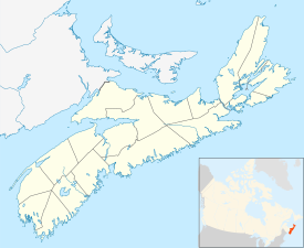
Cape Negro, Nova Scotia
Cape Negro | |
|---|---|
 Location of Cape Negro, Nova Scotia | |
| Coordinates: 43°33′09″N 65°26′33″W / 43.5525°N 65.4425°W[1] | |
| Country | |
| Province | |
| County | Shelburne |
| Municipal district | Barrington |
| Time zone | UTC-4 (AST) |
| • Summer (DST) | UTC-3 (ADT) |
| Postal code(s) | B0W 1K0 |
| Area code(s) | 902 |
| Access Routes | |
Cape Negro is a community in the Canadian province of Nova Scotia, located in the Municipality of the District of Barrington of Shelburne County.[3] Cape Sable, Nova Scotia By one account, Cape Negro was first settled by the French who migrated from Port Royal, Nova Scotia in 1720.[4] However other records indicate the habitation and garden of a French Priest at the Hawl Over (or Haulover) in Cape Negro as early as 1635, and the 1671 French census records the family of Amand and Elizabeth Lalloue living in Cape Negro.[5]
History[]
The cape was named by Samuel de Champlain, who wrote in 1604: "There is a harbour very good for vessels, and the head of it has a little river, which runs from a distance inland, which I named the port Cape Negro, on account of a rock which at a distance resembles one, four leagues from it and four from Port Mouton. The cape is very dangerous on account of the rocks."[6]
The first mention of permanent European habitation was that of a French Priest in 1635. What remains of the 1671 French census indicates a family of seven (Amand Lalloue) living in Cape Negro, with a farm which included grain, peas and other vegetables as well as sizeable herds of goats and pigs. Several Mi'kmaq families with children lived in Cape Negro, at least during the summer.[7]
Practically all of the Acadians were expelled by the English / New England military forces by 1758, and the New England Planters began to settle the formerly Acadian farmland by 1760-1761. The earliest New England Planters in Cape Negro were: Peleg Coffin, Sacco Barnes, Timothy Bryant, Samuel Knowles.[8]
Although there was at one time a Cape Negro school and community hall, all that remains today are the Cape Negro Church (current building built 1853) and adjacent cemeteries (Seaview Cemetery, 1770. Hillside Cemetery, 1958). The remnants of the canal built at the Hawl Over also remain.[9] The Cape Negro Church has the distinction of having Freeborn Garrettson as one of its first ministers.
Name change[]
- Late 2016, application made to Nova Scotia Geographic Information Service to rename Cape Negro (and Cape Negro Island, Negro Harbour, Squaw Island). Awaiting Indigenous and community support.[10]
See also[]
References[]
- ^ Nova Scotia Geographical Names: Cape Negro[permanent dead link]
- ^ a b 2006 Statistics Canada Community Profile: Barrington Municipal District, Nova Scotia
- ^ Government of Nova Scotia website: Community Counts
- ^ M. A. MacDonald. Fortune and La Tour. Methuen Press. 1983.p.14
- ^ Joseph R. Ross. History of Cape Negro and Blanche. Passage Print and Litho Ltd, Barrington Passage, NS. 1987. p. 7-8
- ^ Joseph R. Ross. History of Cape Negro and Blanche. Passage Print and Litho Ltd, Barrington Passage, NS. 1987. p. 4
- ^ Joseph R. Ross. History of Cape Negro and Blanche. Passage Print and Litho Ltd, Barrington Passage, NS. 1987. p.6-8
- ^ Joseph R. Ross. History of Cape Negro and Blanche. Passage Print and Litho Ltd, Barrington Passage, NS. 1987. p. 9-11
- ^ Joseph R. Ross. History of Cape Negro and Blanche. Passage Print and Litho Ltd, Barrington Passage, NS. 1987.
- ^ Pam, Berman (17 June 2020). "2 years after complaint, review for Barrington communities with offensive names pending | CBC News". CBC News.
Coordinates: 43°33′09″N 65°26′33″W / 43.55250°N 65.44250°W
- Communities in Shelburne County, Nova Scotia
- General Service Areas in Nova Scotia
- Populated coastal places in Canada
- 1635 establishments in the French colonial empire
