Caribbean Terrane
| Caribbean Terrane Stratigraphic range: Late Cretaceous (emplaced) ~ | |
|---|---|
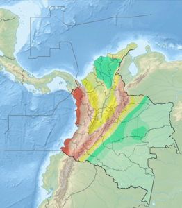
 The Caribbean Terrane is enclosed by the Bucaramanga-Santa Marta Fault (orange), Romeral Fault System (violet) and plate boundaries with Coiba (red) and Malpelo Plates (purple) | |
| Type | Terrane |
| Unit of | North Andes Plate |
| Sub-units | Subunits |
| Overlies | , Tahamí & |
| Lithology | |
| Primary | Complexes, basins |
| Other | Volcanoes |
| Location | |
| Coordinates | 6°28′00″N 77°00′00″W / 6.46667°N 77.00000°WCoordinates: 6°28′00″N 77°00′00″W / 6.46667°N 77.00000°W |
| Region | Caribbean, Pacific/Chocó |
| Country | |
| Extent | Central, Western, Darién, Baudó, Montes de María |
| Type section | |
| Named for | Caribbean |
 Caribbean Terrane (Colombia) | |


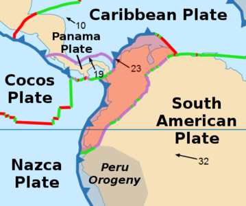
The Caribbean Terrane (Spanish: Terreno del Caribe, TC) is one of the geological provinces (terranes) of Colombia. The terrane, dating to the Late Cretaceous, is situated on the North Andes Plate and borders the La Guajira, Chibcha and underlying Tahamí Terrane along the regional Bucaramanga-Santa Marta Fault.[1] The terrane overlies the Tahamí, and along the Romeral Fault System.[2][3]
Reinterpretation[]
A study performed by Mora Bohórquez et al. in 2017 showed no basement variation between the Chibcha Terrane San Lucas basement underlying the (VIM) and the SNSM basement to the east of the Santa Marta Fault. The authors redefined the contacts between the different terranes, using the names for the coastal portion of the Caribbean Terrane ( and ) and Tahamí-Panzenú Terrane for the Tahamí Terrane.[4]
Subdivision[]
Domains[]
The terrane was subdivided by Fuck et al. (2008) into:[5][6]
- Oceanic crust
Complexes[]
- Batholiths
Volcanoes[]
Ranges[]
- Central
- Western
- Nudo de los Pastos
- Darién
- Baudó
- Montes de María
Basins[]
Faults[]
Gallery[]
North Andes Plate
Seismic activity map

Geologic map (Codazzi, 1890)

Paleogeography of the Late Cretaceous (Blakey)


See also[]
- List of earthquakes in Colombia
- List of fossiliferous stratigraphic units in Colombia
- List of mining areas in Colombia
- Geology of the Eastern Hills of Bogotá
- Cesar-Ranchería Basin
- Cocinetas Basin
- Middle Magdalena Valley (VMM)
References[]
- ^ a b Paris et al., 2000, p.10
- ^ a b Paris et al., 2000, pp.20–26
- ^ Gómez Tapias et al., 2015, p.209
- ^ Mora Bohórquez et al., 2017, p.20
- ^ Fuck et al., 2008, p.112
- ^ Guiral Vega et al., 2015, p.42
- ^ a b c d e Vallejo Hincapié et al., 2011, p.48
- ^ Vallejo Hincapié et al., 2011, p.56
- ^ Vallejo Hincapié et al., 2011, p.55
- ^ a b Paris et al., 2000, p.18
- ^ a b Paris et al., 2000, p.51
- ^ a b Paris et al., 2000, p.17
- ^ Paris et al., 2000, p.52
- ^ a b Paris et al., 2000, p.14
- ^ Paris et al., 2000, p.12
- ^ Paris et al., 2000, p.54
- ^ a b Paris et al., 2000, p.55
- ^ Paris et al., 2000, p.26
- ^ Paris et al., 2000, p.53
- ^ Paris et al., 2000, p.13
- ^ Paris et al., 2000, p.15
Bibliography[]
Terranes[]
- ; ; ; ; , and . 2015. Geological Map of Colombia, 1–212. Servicio Geológico Colombiano. Accessed 2019-10-29.
- ; ; , and . 2009. Terrenos, complejos y provincias en la Cordillera Central de Colombia (Terrains, complexes and provinces in the central cordillera of Colombia). 9. 49-56. Accessed 2019-10-31.
- ; ; ; , and . 2003. Geochronology of Proterozoic basement from the Colombian Andes: Tectonic history of remnants from a fragmented Grenville Belt, 1-10. 10o Congreso Geológico Chileno.
- , and . 1988. Terranes and continental accretion in the Colombian Andes. Episodes 11. 189-193. Accessed 2019-10-31.
Caribbean Terrane[]
- ; ; ; ; ; , and . 2017. Structure and age of the Lower Magdalena Valley basin basement, northern Colombia: New reflection-seismic and U-Pb-Hf insights into the termination of the central andes against the Caribbean basin. Journal of South American Earth Sciences 74. 1-26. Accessed 2019-10-29.
- ; , and . 2011. Petrografía y geoquímica de las rocas intrusivas aflorantes entre los municipios de Mistrató y Belén de Umbría (Departamento de Risaralda, Cordillera Occidental Colombiana). Boletín de Geología 33. 47-57. Accessed 2019-10-29.
- ; , and . 2008. Rodinia descendants in South America. Precambrian Research 160. 108–126. Accessed 2019-10-29.
- ; ; , and . 2000. Map and Database of Quaternary Faults and Folds in Colombia and its Offshore Regions, 1–66. USGS. Accessed 2017-06-20.
- ; ; , and . 2000b. Map of Quaternary Faults and Folds of Colombia and Its Offshore Regions, 1. USGS. Accessed 2017-09-18.
Reports[]
- . 2001. Mapa Geológico del Departamento de Antioquia - 1:400,000 - Memoria explicativa, 1–120. INGEOMINAS.
- , and . 2000. Mapa geológico generalizado del Departamento de Bolívar - 1:400,000 - Memoria explicativa, 1–99. INGEOMINAS. Accessed 2017-08-31.
Maps[]
- ; ; ; , and . 2010. Plancha 58 - Sapzurro - 1:100,000, 1. INGEOMINAS. Accessed 2017-06-06.
- , and . 1999. Plancha 93 - Cáceres - 1:100,000, 1. INGEOMINAS. Accessed 2017-06-06.
- ; ; ; , and . 1975. Plancha 104 - Ituango - 1:100,000, 1. INGEOMINAS. Accessed 2018-06-01.
- ; , and . 2013. Plancha 114 - Dabeiba - 1:100,000, 1. Servicio Geológico Colombiano. Accessed 2018-06-01.
- , and . 2002. Plancha 128 - Murrí - 1:100,000, 1. INGEOMINAS. Accessed 2017-06-06.
- , and . 2005. Plancha 165 - Carmen de Atrato - 1:100,000, 1. INGEOMINAS. Accessed 2018-06-01.
- , and . 1994. Plancha 204 - Pueblo Rico - 1:100,000, 1. INGEOMINAS. Accessed 2017-06-06.
- , and . 1985. Plancha 300 - Cali - 1:100,000, 1. INGEOMINAS. Accessed 2017-06-06.
| Tectonic plates |    | ||||||||||
|---|---|---|---|---|---|---|---|---|---|---|---|
| Terranes |
| ||||||||||
| Terrane-bounding fault systems | |||||||||||
| Intraterrane faults |
| ||||||||||
| Major earthquakes | |||||||||||
| Orogenies | |||||||||||
| Other topics | |||||||||||
| Sources |
| ||||||||||
- Terranes
- Geology of Colombia
- Cretaceous Colombia
- Late Cretaceous South America
- Geography of Antioquia Department
- Geography of Atlántico Department
- Geography of Caldas Department
- Geography of Cauca Department
- Geography of Chocó Department
- Geography of Córdoba Department
- Geography of Magdalena Department
- Geography of Nariño Department
- Geography of Quindío Department
- Geography of Risaralda Department
- Geography of Sucre Department
- Geography of Valle del Cauca Department
- Geology of the Andes