Chibcha Terrane
| Chibcha Terrane Stratigraphic range: Meso-Neoproterozoic ~ | |
|---|---|
 Chibcha Terrane is enclosed by the Bucaramanga-Santa Marta Fault (orange), northernmost Oca Fault (white), Eastern Frontal Fault System (yellow) and Romeral Fault System (violet) | |
| Type | Terrane |
| Unit of | North Andes Plate |
| Sub-units | Subunits |
| Underlies | Tahamí & La Guajira Terranes |
| Overlies | |
| Lithology | |
| Primary | Complexes, basins |
| Other | Volcanoes |
| Location | |
| Coordinates | 4°43′22.4″N 74°04′23.7″W / 4.722889°N 74.073250°WCoordinates: 4°43′22.4″N 74°04′23.7″W / 4.722889°N 74.073250°W |
| Region | Andean |
| Country | |
| Extent | Central, Eastern, Perijá, SNSM, San Lucas, La Macarena |
| Type section | |
| Named for | Chibcha |
 Chibcha Terrane (Colombia) | |

The Chibcha Terrane (Spanish: Terreno Chibcha, TCH), named after Chibcha, is the largest of the geological provinces (terranes) of Colombia. The terrane, the oldest explored domains of which date to the Meso- to Neoproterozoic, is situated on the North Andes Plate. The megaregional Romeral Fault System forms the contact of the terrane with the Tahamí Terrane.[1] The contact with the Caribbean and La Guajira Terranes is formed by the regional Bucaramanga-Santa Marta Fault.[2] The northeastern boundary is formed by the regional Oca Fault, bounding the La Guajira Terrane.[3] The terrane is emplaced over the of the Amazonian Craton along the megaregional Eastern Frontal Fault System.[4][5]
Reinterpretation[]
A study performed by Mora Bohórquez et al. in 2017 showed no basement variation between the San Lucas basement underlying the (VIM) and the SNSM basement to the east of the Santa Marta Fault. The authors redefined the contacts between the different terranes, using the names for the coastal portion of the Caribbean Terrane ( and ) and Tahamí-Panzenú Terrane for the Tahamí Terrane.[6]
Subdivision[]


Some authors consider the Garzón Complex a separate terrane; the Andaquí Terrane.[7][8][9]
Complexes[]
- SNSM - Early Eocene
- SNSM Paleozoic
- - Lopingian[10]
- - Carboniferous (~Moscovian) to Permian (Guadalupian)[10]
- - basement[10]
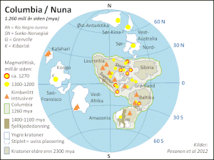
- - Mesoproterozoic (1000 Ma)[11]
- Sierra Nevada de Santa Marta (La Guajira Terrane)
- - Cisuralian-Guadalupian[12]
- - Moscovian-Gzhelian[12]
- Río Cachirí
- [13] or - Silurian (Ludlow)[10]
- - Neoproterozoic basement[10]
- - Neoproterozoic-Ordovician
- - Lopingian[10]
- - Artinskian-Guadalupian[12]
- - Givetian[10]
- (formerly 'Silgará Formation')[14]
- (idem)[14]
- - basement[10][15]
- - Cambro-Ordovician
- - Carboniferous-Devonian[18]
- , - Silurian (Ludlow)[10]
- - Cambro-Ordovician[10]
- Neoproterozoic unnamed basement[10]
- La Macarena - Mesoproterozoic
- San Lucas - Cambrian
- Southwestern Chibcha
Andaquí Terrane[]
- - Neoproterozoic
Volcanoes[]
Ranges[]
Basins[]
- Cesar-Ranchería[22][23]
- Middle Magdalena (VMM)[24][25]
- (VSM)
Faults[]
bounding faults in bold
- Bucaramanga-Santa Marta (BSF)[2]
- Eastern Frontal (EFS)[4]
- Oca[3]
- Otú Norte[26]
- La Palestina (LPF)[27]
- Romeral (RFS)[1]
- Bagre Norte[26]
- Bogotá[28]
- Caño Tomás[29]
- Chitagá-Pamplona[30]
- Cimitarra[31]
- Cucuana[32]
- La Dina[33]
- Honda[34]
- Ibagué[35]
- Irlanda[36]
- La Macarena[28]
- La Plata[36]
- Suárez[37]
- Tarra[38]
- Usme[39]
- Vianí[39]
Gallery[]

North Andes Plate
Seismic activity map

Map of Chibcha-speaking peoples

Extent of the Chibcha
Paleogeography of the Mesoproterozoic


See also[]
- List of earthquakes in Colombia
- List of fossiliferous stratigraphic units in Colombia
- List of mining areas in Colombia
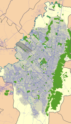
- Geology of the Eastern Hills of Bogotá
- List of Muisca toponyms
- Cocinetas Basin
References[]
- ^ a b Paris et al., 2000, pp.20–26
- ^ a b Paris et al., 2000, p.10
- ^ a b Paris et al., 2000, p.9
- ^ a b Paris et al., 2000, pp.36-46
- ^ Gómez Tapias et al., 2015, p.209
- ^ Mora Bohórquez et al., 2017, p.20
- ^ Cordani et al., 2003, p.9
- ^ Restrepo et al., 2009, p.50
- ^ Guiral Vega et al., 2015, p.42
- ^ a b c d e f g h i j k l m n Pastor Chacón et al., 2013, p.7
- ^ Cordani et al., 2003, p.4
- ^ a b c Pastor Chacón et al., 2013, p.17
- ^ Plancha 42, 2015, p.24
- ^ a b Mantilla Figueroa et al., 2015, p.42
- ^ Mantilla Figueroa et al., 2015, p.43
- ^ a b c d Manosalva Sánchez et al., 2017, p.84
- ^ Renzoni, 1968
- ^ Moreno Sánchez et al., 2009, p.53
- ^ Toro Toro et al., 2014, p.22
- ^ Monsalve et al., 2011
- ^ Vesga & Jaramillo, 2009
- ^ Barrero et al., 2007, p.35
- ^ García González et al., 2007, p.83
- ^ Barrero et al., 2007, p.78
- ^ Garcia González et al., 2009, p.80
- ^ a b Paris et al., 2000a, p.29
- ^ Paris et al., 2000a, p.30
- ^ a b Paris et al., 2000a, p.47
- ^ Paris et al., 2000a, p.11
- ^ Paris et al., 2000a, pp.38-39
- ^ Paris et al., 2000a, pp.30-31
- ^ Paris et al., 2000a, p.49
- ^ Paris et al., 2000a, p.58
- ^ Paris et al., 2000a, p.32
- ^ Paris et al., 2000a, p.50
- ^ a b Paris et al., 2000a, p.57
- ^ Paris et al., 2000a, p.34
- ^ Paris et al., 2000a, p.12
- ^ a b Paris et al., 2000a, p.48
Bibliography[]
Terranes[]
- ; ; ; ; , and . 2015. Geological Map of Colombia, 1–212. Servicio Geológico Colombiano. Accessed 2019-10-29.
- ; ; , and . 2009. Terrenos, complejos y provincias en la Cordillera Central de Colombia (Terrains, complexes and provinces in the central cordillera of Colombia). 9. 49–56. Accessed 2019-10-31.
- ; ; ; , and . 2003. Geochronology of Proterozoic basement from the Colombian Andes: Tectonic history of remnants from a fragmented Grenville Belt, 1–10. 10o Congreso Geológico Chileno.
- , and . 1988. Terranes and continental accretion in the Colombian Andes. Episodes 11. 189–193. Accessed 2019-10-31.
Chibcha Terrane[]
- ; ; ; , and . 2017. Estudio petrogenetico de las rocas metamorficas del Macizo de Floresta, Cordillera Oriental, Andes Colombianos. Boletín de Geología 39. 83–103. Accessed 2019-10-26.
- ; ; ; ; ; , and . 2017. Structure and age of the Lower Magdalena Valley basin basement, northern Colombia: New reflection-seismic and U-Pb-Hf insights into the termination of the central andes against the Caribbean basin. Journal of South American Earth Sciences 74. 1–26. Accessed 2019-10-29.
- ; , and . 2016. Propuesta de escisión de la denominada 'Formación Silgará' (Macizo de Santander, Colombia), a partir de edades U-Pb en circones detríticos. Boletín de Geología 38. 33–50. Accessed 2019-10-26.
- ; , and . 2014. Metagabro del Ariari, Plutonismo MORB, Cordillera Oriental de Colombia. Boletín de Geología 36. 15–24. Accessed 2019-10-26.
- , and . 2013. Petrografía, petrología y análisis de procedencia de unidades paleógenas en las cuencas Cesar - Ranchería y Catatumbo. Boletín de Geología 35. 67–80. Accessed 2017-06-14.
- ; ; ; , and . 2013. Análisis estratigráfico de la sucesión del Devónico-Pérmico al oriente de Manaure y San José de Oriente (Serranía del Perijá, Colombia). 38. 5–24. Accessed 2019-10-31.
- ; ; , and . 2012. Análisis estructural del segmento Bucaramanga del Sistema de Fallas de Bucaramanga (sfb) entre los municipios de Pailitas y Curumaní, Cesar - Colombia. Boletín de Geología 34. 73–101. Accessed 2017-06-09.
- ; ; ; ; ; ; ; , and . 2011. Early-subduction-related orogeny in the northern Andes: Turonian to Eocene magmatic and provenance record in the Santa Marta Massif and Rancheria Basin, northern Colombia. Terra Nova 23. 26–34. Accessed 2018-05-12.
- ; ; ; , and . 2011. Caracterización geológica del cuerpo volcánico de Iza, Boyacá - Colombia. Boletín de Geología 33. 117–130. Accessed 2017-02-25.
- ; ; ; , and . 2011. Reactivación Neógena de estructuras de rift del Cretácico Temprano asociadas con la Falla de Chámeza, Pajarito, Boyacá (Colombia): evidencias tectónicas y bioestratigráficas. 36. 197–216. Accessed 2017-08-04.
- . 2009. Análisis tectonoestratigráfico y de procedencia en la Subcuenca de Cesar: Relación con los sistemas petroleros (MSc.), 1–255. Universidad Simón Bolívar. Accessed 2017-06-14.
- ; ; , and . 2009. Informe Ejecutivo - evaluación del potencial hidrocarburífero de las cuencas colombianas, 1–219. Universidad Industrial de Santander.
- ; ; ; ; , and . 2009. Reconstrucción de la historia termal en el piedemonte occidental de la Serranía del Perijá entre Codazzi y La Jagua de Ibirico - Cuenca de Cesar-Ranchería, 1–85. Universidad Nacional de Colombia & . Accessed 2017-06-14.
- ; , and . 2009. Geología del cinturón esmeraldífero oriental (CEOR). Boletín de Geología 31. 51–67. Accessed 2019-10-31.
- , and . 2009. Geoquímica del domo volcánico en el municipio de Iza, Departamento de Boyacá; interpretación geodinámica y comparación con el vulcanismo neógeno de la Cordillera Oriental. Boletín de Geología 31. 97–108. Accessed 2017-02-25.
- ; , and . 2008. Rodinia descendants in South America. Precambrian Research 160. 108–126. Accessed 2019-10-29.
- ; ; , and . 2007. Colombian Sedimentary Basins: Nomenclature, Boundaries and Petroleum Geology, a New Proposal, 1–92. .
- ; ; ; ; , and . 2007. Procesos orogénicos del Paleoceno para la cuenca de Ranchería (Guajira, Colombia) y áreas adyacentes definidos por análisis de procedencia. 32. 21–46. Accessed 2017-06-14.
- ; ; ; , and . 2003. Geochronology of Proterozoic basement from the Colombian Andes: Tectonic history of remnants from a fragmented Grenville Belt, 1–10. 10o Congreso Geológico Chileno.
- ; ; , and . 2000. Map and Database of Quaternary Faults and Folds in Colombia and its Offshore Regions, 1–66. USGS. Accessed 2017-06-20.
- ; ; , and . 2000b. Map of Quaternary Faults and Folds of Colombia and Its Offshore Regions, 1. USGS. Accessed 2017-09-18.
- . 1968. Geología del Macizo de Quetame. 5. 75–128. Accessed 2019-10-31.
Reports[]
- . 2001. Mapa Geológico del Departamento de Antioquia - 1:400,000 - Memoria explicativa, 1–120. INGEOMINAS.
- , and . 2005. Geología de la Sabana de Bogotá, 1–104. INGEOMINAS.
- , and . 2000. Mapa geológico generalizado del Departamento de Bolívar - 1:400,000 - Memoria explicativa, 1–99. INGEOMINAS. Accessed 2017-08-31.[permanent dead link]
- , and . 2000. Mapa Geológico del Departamento de Boyacá - 1:250,000 - Memoria explicativa, 1–120. INGEOMINAS. Accessed 2019-03-10.
- , and . 2002. Mapa geológico del Departamento de Cundinamarca 1:250,000 - Memoria Explicativa, 1–108. INGEOMINAS.
- , and . 2002. Mapa geológico del Departamento de La Guajira - 1:250,000, 1–259. INGEOMINAS. Accessed 2017-08-08.
- , and . 2001. Mapa geológico del Departamento de Santander 1:400,000 - Memoria Explicativa, 1–92. INGEOMINAS.
- ; ; ; ; ; ; ; , and . 2007. Geología de las Planchas 11, 12, 13, 14, 18, 19, 20, 21, 25, 26, 27, 33, 34, y 40 - Sierra Nevada de Santa Marta, 1–401. INGEOMINAS, -Ecopetrol, INVEMAR, GeoSearch.
- . 2015. Geología de la Plancha 42 - Serranía de Perijá - 1:100,000, 1–39. Servicio Geológico Colombiano.
- , and . 2001. Geología de la Plancha 208 Villeta - 1:100,000, 1–84. INGEOMINAS. Accessed 2017-04-04.
- ; ; ; ; ; , and . 2008. Geología del cinturón esmeraldífero oriental Planchas 210, 228, 229, 1−126. INGEOMINAS.
- , and . 2001. Geología de la Plancha 227 - La Mesa - 1:100,000, 1–80. INGEOMINAS.
- ; ; ; ; ; ; ; , and . 2013. Geología de la Plancha 229 - Gachalá - 1:100,000, 1–296. Servicio Geológico Colombiano. Accessed 2018-06-01.
- ; ; ; ; ; ; ; , and . 2011. Cartografía geológica de la Plancha 247 - Cáqueza - 1:100,000, 1–100. INGEOMINAS. Accessed 2017-08-04.
- , and . 2001. Geología de la Plancha 266 - Villavicencio - 1:100,000, 1–52. INGEOMINAS.
- , and . 2002. Geología de la Plancha 303 - Colombia - 1:100,000, 1–88. INGEOMINAS.
- . 2015. Geología de la Plancha 348 - Serranía de la Macarena - 1:100,000, 1–101. Servicio Geológico Colombiano.
- . 2002. Geología de las Planchas 367 Gigante, 368 San Vicente del Caguán, 389 Timaná, 390 Puerto Rico, 391 Lusitania (parte noroccidental) y 414 El Doncello, 1–164. INGEOMINAS.
- . 2003. Cartografía geológica de las zonas Andina Sur y Garzón-Quetame (Colombia) - Memoria explicativa de las planchas 411 La Cruz, 412 San Juan de Villalobos, 430 Mocoa, 431 Piamonte, 448 Monopamba, 449 Orito y 465 Churuyaco, 1–298. INGEOMINAS.
Maps[]
- , and . 1999. Plancha 18 - Ciénaga - 1:100,000, 1. INGEOMINAS. Accessed 2017-06-06.
- ; ; ; ; ; ; ; , and . 2007. Plancha 19 - Sierra Nevada de Santa Marta - 1:100,000, 1. INGEOMINAS. Accessed 2017-06-06.
- ; ; ; ; ; ; ; , and . 2007. Plancha 26 - Pueblobello - 1:100,000, 1. INGEOMINAS. Accessed 2017-06-06.
- ; ; ; ; ; ; ; , and . 2007. Plancha 33 - El Copey - 1:100,000, 1. INGEOMINAS. Accessed 2017-06-06.
- ; ; ; ; , and . 2010. Plancha 120 - Bucaramanga - 1:100,000, 1. INGEOMINAS. Accessed 2017-06-06.
- ; ; ; ; ; ; ; , and . 2008. Plancha 149 - Puerto Serviez - 1:100,000, 1. INGEOMINAS. Accessed 2017-06-06.
- ; , and . 1998. Plancha 172 - Paz de Río - 1:100,000, 1. INGEOMINAS. Accessed 2017-06-06.
- , and . 2009. Plancha 188 - La Dorada - 1:100,000, 1. INGEOMINAS. Accessed 2017-06-06.
- , and . 2010. Plancha 207 - Honda - 1:100,000, 1. INGEOMINAS. Accessed 2017-06-06.
- , and . 2010. Plancha 226 - Líbano - 1:100,000, 1. INGEOMINAS. Accessed 2017-06-06.
- ; ; , and . 1999. Plancha 245 - Girardot - 1:100,000, 1. INGEOMINAS. Accessed 2017-06-06.
- ; , and . 1993. Plancha 282 - Chaparral - 1:100,000, 1. INGEOMINAS. Accessed 2017-06-06.
- ; , and . 1995. Plancha 283 - Purificación - 1:100,000, 1. INGEOMINAS. Accessed 2017-06-06.
- ; ; , and . 1993. Plancha 302 - Aipe - 1:100,000, 1. INGEOMINAS. Accessed 2017-06-06.
- ; , and . 1998. Plancha 323 - Neiva - 1:100,000, 1. INGEOMINAS. Accessed 2017-06-06.
- . 2015. Plancha 326 - Vista Hermosa - 1:100,000, 1. Servicio Geológico Colombiano. Accessed 2018-06-01.
- ; , and . 1999. Plancha 344 - Tesalia - 1:100,000, 1. INGEOMINAS. Accessed 2017-06-06.
- ; ; , and . 1998. Plancha 366 - Garzón - 1:100,000, 1. INGEOMINAS. Accessed 2017-06-06.
- . 2015. Plancha 348 - Serranía de la Macarena - 1:100,000, 1. Servicio Geológico Colombiano. Accessed 2018-06-01.
- ; , and . 2003. Plancha 367 - Gigante - 1:100,000, 1. INGEOMINAS. Accessed 2017-06-06.
- ; , and . 20002. Plancha 388 - Pitalito - 1:100,000, 1. INGEOMINAS. Accessed 2017-06-06.
- ; , and . 2003. Plancha 389 - Timaná - 1:100,000, 1. INGEOMINAS. Accessed 2017-06-06.
- ; , and . 2003. Plancha 390 - Puerto Rico - 1:100,000, 1. INGEOMINAS. Accessed 2017-06-06.
- ; , and . 2003. Plancha 391 - Lusitania - 1:100,000, 1. INGEOMINAS. Accessed 2017-06-06.
- , and . 2002. Plancha 412 - San Juan de Villalobos - 1:100,000, 1. INGEOMINAS. Accessed 2017-06-06.
- ; , and . 2003. Plancha 414 - El Doncello - 1:100,000, 1. INGEOMINAS. Accessed 2017-06-06.
- , and . 2002. Plancha 430 - Mocoa - 1:100,000, 1. INGEOMINAS. Accessed 2017-06-06.
- , and . 2002. Plancha 431 - Piamonte - 1:100,000, 1. INGEOMINAS. Accessed 2017-06-06.
- , and . 2002. Plancha 448 - Monopamba - 1:100,000, 1. INGEOMINAS. Accessed 2017-06-06.
- , and . 2002. Plancha 449 - Orito - 1:100,000, 1. INGEOMINAS. Accessed 2017-06-06.
- , and . 2002. Plancha 465 - Churiyaco - 1:100,000, 1. INGEOMINAS. Accessed 2017-06-06.
| Tectonic plates |    | ||||||||||
|---|---|---|---|---|---|---|---|---|---|---|---|
| Terranes |
| ||||||||||
| Terrane-bounding fault systems | |||||||||||
| Intraterrane faults |
| ||||||||||
| Major earthquakes | |||||||||||
| Orogenies | |||||||||||
| Other topics | |||||||||||
| Sources |
| ||||||||||
- Terranes
- Geology of Colombia
- Neoproterozoic South America
- Precambrian South America
- Mesoproterozoic geology
- Geography of Antioquia Department
- Geography of Arauca Department
- Geography of Bogotá
- Geography of Bolívar Department
- Geography of Boyacá Department
- Geography of Caquetá Department
- Geography of Casanare Department
- Geography of Cesar Department
- Geography of Cundinamarca Department
- Geography of Huila Department
- Geography of Magdalena Department
- Geography of Meta Department
- Geography of Putumayo Department
- Geography of Norte de Santander Department
- Geography of Santander Department
- Geography of Tolima Department
- Sierra Nevada de Santa Marta
- Geology of the Andes
- Muysccubun