Cerhenice
Cerhenice | |
|---|---|
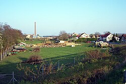 View on Cerhenice | |
 Flag  Coat of arms | |
 Cerhenice Location in the Czech Republic | |
| Coordinates: 50°4′17″N 15°4′20″E / 50.07139°N 15.07222°ECoordinates: 50°4′17″N 15°4′20″E / 50.07139°N 15.07222°E | |
| Country | |
| Region | Central Bohemian |
| District | Kolín |
| First mentioned | 1295 |
| Area | |
| • Total | 10.64 km2 (4.11 sq mi) |
| Elevation | 209 m (686 ft) |
| Population (2021-01-01)[1] | |
| • Total | 1,783 |
| • Density | 170/km2 (430/sq mi) |
| Time zone | UTC+1 (CET) |
| • Summer (DST) | UTC+2 (CEST) |
| Postal codes | 280 02, 281 02 |
| Website | www |

Cerhenice is a market town in Kolín District in the Central Bohemian Region of the Czech Republic. It has about 1,800 inhabitants.
Administrative parts[]
The village of Cerhýnky is an administrative part of Cerhenice.
References[]
| Wikimedia Commons has media related to Cerhenice. |
| Authority control: National libraries |
|---|
Categories:
- Populated places in Kolín District
- Market towns in the Czech Republic
- Kolín geography stubs