Cerro de la Viga
| Cerro de la Viga | |
|---|---|
| Sierra de la Viga Cerro San Rafael | |
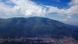 Cerro de la Viga seen from the | |
| Highest point | |
| Elevation | 3,712 m (12,178 ft) |
| Prominence | 1,395 m (4,577 ft) |
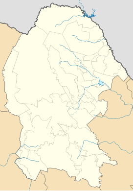
| Coordinates | 25°21′49″N 100°33′26″W / 25.3637°N 100.5571°WCoordinates: 25°21′49″N 100°33′26″W / 25.3637°N 100.5571°W |
| Geography | |
 Cerro de la Viga | |
| Parent range | Sierra Madre Oriental |
The Cerro de la Viga is a mountain located in the municipalities of Arteaga, Coahuila and Santiago, Nuevo León in northeastern Mexico. Its peak named Cerro San Rafael culminates at 3,712 m above the sea level and has a prominence of 1,395 m. It is the highest point in Coahuila and the second highest point in the Sierra Madre Oriental and in northern Mexico.[1][2] The mountain is surrounded by the , , Sierra San Isidro, , Sierra El Muerto (Santiago), El Coahuilón, and Cerro La Mina.
Its 40-km-long ridge is the border between Coahuila and Nuevo León over 22 km.
In June 2011, a fire affected the southern side of the mountain.[3]
See also[]
References[]
- ^ "Cerro San Rafael". peakbagger.com. November 1, 2004. Retrieved December 30, 2018.
- ^ "Cerro San Rafael". bivouac.com. Retrieved December 30, 2018.
- ^ "Incontrolable el incendio". El Diario de Coahuila (in Spanish). Archived from the original on April 11, 2019. Retrieved April 11, 2019.
This article about a location in the Mexican state of Coahuila is a stub. You can help Wikipedia by . |
This North America mountain, mountain range, or peak related article is a stub. You can help Wikipedia by . |
- Sierra Madre Oriental
- Mountains of Mexico
- North American 3000 m summits
- Landforms of Coahuila
- Landforms of Nuevo León
- Coahuila geography stubs
- North America mountain stubs