Châtel-Montagne
show This article may be expanded with text translated from the corresponding article in French. (December 2008) Click [show] for important translation instructions. |
Châtel-Montagne | |
|---|---|
Commune | |
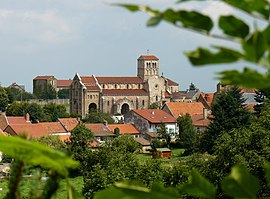 The church and surrounding buildings in Châtel-Montagne | |
 Coat of arms | |
show Location of Châtel-Montagne | |
 Châtel-Montagne | |
| Coordinates: 46°06′50″N 3°41′01″E / 46.1139°N 3.6836°ECoordinates: 46°06′50″N 3°41′01″E / 46.1139°N 3.6836°E | |
| Country | France |
| Region | Auvergne-Rhône-Alpes |
| Department | Allier |
| Arrondissement | Vichy |
| Canton | Lapalisse |
| Intercommunality | Vichy Communauté |
| Government | |
| • Mayor (2020–2026) | Jean-Claude Brat[1] |
| Area 1 | 36.81 km2 (14.21 sq mi) |
| Population (Jan. 2018)[2] | 336 |
| • Density | 9.1/km2 (24/sq mi) |
| Time zone | UTC+01:00 (CET) |
| • Summer (DST) | UTC+02:00 (CEST) |
| INSEE/Postal code | 03066 /03250 |
| Elevation | 331–972 m (1,086–3,189 ft) (avg. 530 m or 1,740 ft) |
| 1 French Land Register data, which excludes lakes, ponds, glaciers > 1 km2 (0.386 sq mi or 247 acres) and river estuaries. | |


Châtel-Montagne (French pronunciation: [ʃatɛl mɔ̃taɲ]; Occitan: Chastèlmontanha) is a commune in the Allier department in central France.
Population[]
| Year | Pop. | ±% |
|---|---|---|
| 1962 | 420 | — |
| 1968 | 572 | +36.2% |
| 1975 | 501 | −12.4% |
| 1982 | 426 | −15.0% |
| 1990 | 400 | −6.1% |
| 1999 | 373 | −6.8% |
| 2008 | 419 | +12.3% |
| 2012 | 395 | −5.7% |
See also[]
- Communes of the Allier department
References[]
- ^ "Liste nominative des communes de l'Allier" [Nominative list of communes of Allier] (PDF) (in French). Association of Mayors and Presidents of Communities of Allier. 8 July 2020. Retrieved 6 December 2020.
- ^ "Populations légales 2018". INSEE. 28 December 2020.
| Wikimedia Commons has media related to Châtel-Montagne. |
| show Communes of the Allier department |
|---|
| Authority control |
|
|---|
This Allier geographical article is a stub. You can help Wikipedia by . |
Categories:
- Communes of Allier
- Allier geography stubs