Saint-Bonnet-de-Rochefort
show This article may be expanded with text translated from the corresponding article in French. (December 2008) Click [show] for important translation instructions. |
Saint-Bonnet-de-Rochefort | |
|---|---|
Commune | |
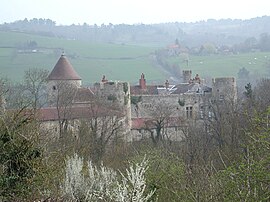 Chateau of Rochefort | |
 Coat of arms | |
show Location of Saint-Bonnet-de-Rochefort | |
 Saint-Bonnet-de-Rochefort | |
| Coordinates: 46°08′50″N 3°08′21″E / 46.1472°N 3.1392°ECoordinates: 46°08′50″N 3°08′21″E / 46.1472°N 3.1392°E | |
| Country | France |
| Region | Auvergne-Rhône-Alpes |
| Department | Allier |
| Arrondissement | Vichy |
| Canton | Gannat |
| Intercommunality | Saint-Pourçain Sioule Limagne |
| Government | |
| • Mayor (2020–2026) | Henri Giraud[1] |
| Area 1 | 16.36 km2 (6.32 sq mi) |
| Population (Jan. 2018)[2] | 704 |
| • Density | 43/km2 (110/sq mi) |
| Time zone | UTC+01:00 (CET) |
| • Summer (DST) | UTC+02:00 (CEST) |
| INSEE/Postal code | 03220 /03800 |
| Elevation | 290–412 m (951–1,352 ft) (avg. 334 m or 1,096 ft) |
| 1 French Land Register data, which excludes lakes, ponds, glaciers > 1 km2 (0.386 sq mi or 247 acres) and river estuaries. | |


Saint-Bonnet-de-Rochefort (Auvergnat: Sant Bonet de Ròchafòrt) is a commune in the Allier department in Auvergne-Rhône-Alpes in central France.
Geography[]
Saint-Bonnet-de-Rochefort is located in the south of the Allier department, 9 kilometres (5.6 mi) of Gannat, 3 kilometres (1.9 mi) of Vicq by departmental road 37; 5 kilometres (3.1 mi) of Ébreuil and Charroux by D35.
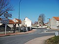
Departmental road 35 passing town centre.

Population[]
| Year | Pop. | ±% |
|---|---|---|
| 1962 | 700 | — |
| 1968 | 701 | +0.1% |
| 1975 | 669 | −4.6% |
| 1982 | 715 | +6.9% |
| 1990 | 712 | −0.4% |
| 1999 | 656 | −7.9% |
| 2008 | 647 | −1.4% |
| 2013 | 663 | +2.5% |
| Source: INSEE (1968–2013) | ||
See also[]
References[]
- ^ "Liste nominative des communes de l'Allier" [Nominative List of Communes of Allier] (PDF) (in French). Association of Mayors and Presidents of Communities of Allier. 8 July 2020. Retrieved 18 November 2020.
- ^ "Populations légales 2018". INSEE. 28 December 2020.
| Wikimedia Commons has media related to Saint-Bonnet-de-Rochefort. |
This Allier geographical article is a stub. You can help Wikipedia by . |
Categories:
- Communes of Allier
- Allier geography stubs