Verneuil-en-Bourbonnais
show This article may be expanded with text translated from the corresponding article in French. (December 2008) Click [show] for important translation instructions. |
Verneuil-en-Bourbonnais | |
|---|---|
Commune | |
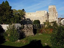 Ruins of the chateau | |
 Coat of arms | |
show Location of Verneuil-en-Bourbonnais | |
 Verneuil-en-Bourbonnais | |
| Coordinates: 46°20′51″N 3°15′09″E / 46.3475°N 3.2525°ECoordinates: 46°20′51″N 3°15′09″E / 46.3475°N 3.2525°E | |
| Country | France |
| Region | Auvergne-Rhône-Alpes |
| Department | Allier |
| Arrondissement | Moulins |
| Canton | Souvigny |
| Intercommunality | Saint-Pourçain Sioule Limagne |
| Government | |
| • Mayor (2020–2026) | Daniel Leger[1] |
| Area 1 | 14.14 km2 (5.46 sq mi) |
| Population (Jan. 2018)[2] | 238 |
| • Density | 17/km2 (44/sq mi) |
| Time zone | UTC+01:00 (CET) |
| • Summer (DST) | UTC+02:00 (CEST) |
| INSEE/Postal code | 03307 /03500 |
| Elevation | 234–356 m (768–1,168 ft) |
| 1 French Land Register data, which excludes lakes, ponds, glaciers > 1 km2 (0.386 sq mi or 247 acres) and river estuaries. | |


Verneuil-en-Bourbonnais (French pronunciation: [vɛʁnœj ɑ̃ buʁbɔnɛ]; Occitan: Vernuelh en Borbonés) is a commune in the Allier department in Auvergne-Rhône-Alpes in central France.
Population[]
| Year | Pop. | ±% |
|---|---|---|
| 1962 | 259 | — |
| 1968 | 329 | +27.0% |
| 1975 | 290 | −11.9% |
| 1982 | 250 | −13.8% |
| 1990 | 280 | +12.0% |
| 1999 | 283 | +1.1% |
| 2008 | 245 | −13.4% |
| 2013 | 254 | +3.7% |
| Source: INSEE (1968–2013) | ||
See also[]
References[]
- ^ "Liste nominative des communes de l'Allier" [Nominative list of communes of Allier] (PDF) (in French). Association of Mayors and Presidents of Communities of Allier. 8 July 2020. Retrieved 22 November 2020.
- ^ "Populations légales 2018". INSEE. 28 December 2020.
| Wikimedia Commons has media related to Verneuil-en-Bourbonnais. |
This Allier geographical article is a stub. You can help Wikipedia by . |
Categories:
- Communes of Allier
- Allier geography stubs