Chandragiri River
| Chandragiri River | |
|---|---|
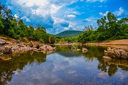 A view of the Chandragiri river from Kanathur, Kasaragod | |
| Etymology | Chandragupta Maurya[4] |
| Location | |
| Country | India |
| State | Kerala, Karnataka |
| District | Kasaragod, Kodagu |
| Cities | Sullia, Jalsoor, Chengala , Kasaragod |
| Physical characteristics | |
| Source | Talakaveri Wildlife Sanctuary, Karnataka |
| • location | Kodagu District, India |
| Mouth | Arabian Sea |
• location | Near Thalangara, Kasaragod, India |
• coordinates | 12°28′25″N 74°59′04″E / 12.4737°N 74.9845°ECoordinates: 12°28′25″N 74°59′04″E / 12.4737°N 74.9845°E |
• elevation | 0 m (0 ft) |
| Length | 105 km (65 mi) |
| Discharge | |
| • location | mouth |
| Basin features | |
| Tributaries | |
| • left | Kudumbur River |

The Chandragiri River also known as Perumpuzha River[1][2][3] is the longest river in Kasaragod district, Kerala, India. It was named after the Mauryan emperor Chandragupta Maurya.[5][6][7]
The 17th century Chandragiri Fort is located on the river.
Perumpuzha river is considered the traditional boundary between the Tulu Nadu and Malayalam regions of Kerala from the fourteenth century AD onwards; before that it was north of Kumbala. [8] The river originates in the Talakaveri Wildlife Sanctuary in the Western Ghats of Kodagu district, Karnataka. It flows through towns including Sullia, Jalsoor, Parappa,Adoor, Chengala, and Kasaragod, where it flows into the Arabian Sea. In Sullia taluk, it is the major water source for domestic and agricultural purposes.
Course[]
The Chandragiri River originates from the northern slopes of the Greater Talacauvery National Park in the Western Ghats at the Kodagu district, Karnataka. Initially the river flows through the Malenadu region of Karnataka passing the Pushpagiri Wildlife Sanctuary and flowing through several hilly towns in Kodagu and Dakshina Kannada like Adyadka, Biliyar, Parivarkana, Paladka, Sullia, Pilikodi and Kanyana. Chandragiri then enters Kerala and flows through several hilly towns in the eastern part of the Kasaragod district, namely Panjikkal, Kottyadi, Adhur, Poovadka, Kottamkuzhy, Bethurpuzha, Kundamkuzhy, Kolathur, Muliyar and Bovikanam. At Bovikanam it's major tributary, Kudumbur River merges with Perumpuzha. Then the river enters into the Malabar plains where it flows through Thekkil, Chengala, Chattanchal, Perumbala, Chemnad and Kasaragod. The Chandragiri River empties into the Arabian Sea at Thalangara in Kasaragod town.
Tributaries[]
The River Chandragiri's largest tributary is the Kudumbur River, which joins the Payaswini on its left bank east of Chattanchal.[9]
See also[]
- Kanhangad
- Kasaragod
- Mangalore
References[]
- ^ a b S. Jayashanker (2001). Temples of Kasaragod District. Controller of Publications. p. 4.
- ^ a b Adoor K. K. Ramachandran Nair (1986). Kerala State Gazetteer. State Editor, Kerala Gazetteers. p. 9.
- ^ a b "Namboothiri Rulers (Naaduvaazhikal)". www.namboothiri.com. Retrieved 12 July 2021.
- ^ "Kasaragod Rivers". www.keralatourism.org. Retrieved 23 January 2021.
- ^ "District Census Handbook - Kodagu District 2011" (PDF). Directorate of Census Operations-Karnataka. 1 October 2011. Retrieved 22 January 2021.
- ^ "District Census Handbook - Dakshina Kannada District 2011" (PDF). Directorate of Census Operations-Karnataka. 1 October 2011. Retrieved 22 January 2021.
- ^ "District Census Handbook - Kasaragod District 2011" (PDF). Directorate of Census Operations-Kerala. 1 October 2011. Retrieved 22 January 2021.
- ^ Bhatt, P. Gururaja (1969). Antiquities of South Kanara. Prabhakara Press. p. 2.
- ^ "Draft Map" (PDF). keralaczma.gov.in. 2012. Retrieved 22 January 2021.
| Wikimedia Commons has media related to Chandragiri River. |
Capital: Thiruvananthapuram | |||||||
| Districts |
| ||||||
| Topics | |||||||
| Symbols |
| ||||||
| Taluks |
| ||||||
| Municipal Corporations | |||||||
| Municipalities |
| ||||||
| Other towns |
| ||||||
| Historical regions |
| ||||||
This article related to a location in Kasaragod district, Kerala, India is a stub. You can help Wikipedia by . |
- Rivers of Kasaragod district
- Tourist attractions in Kasaragod district
- Kasaragod district geography stubs
- India river stubs