Chautauqua County, New York
Chautauqua County | |
|---|---|
 Chautauqua County Courthouse in Mayville | |
 Seal | |
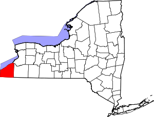 Location within the U.S. state of New York | |
 New York's location within the U.S. | |
| Coordinates: 42°18′N 79°25′W / 42.3°N 79.41°W | |
| Country | |
| State | |
| Founded | February 9, 1811 |
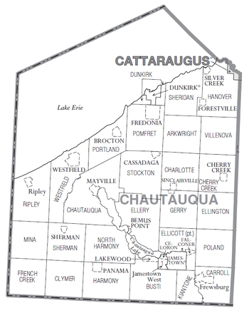
| Seat | Mayville |
| Largest city | Jamestown |
| Area | |
| • Total | 1,500 sq mi (4,000 km2) |
| • Land | 1,060 sq mi (2,700 km2) |
| • Water | 440 sq mi (1,100 km2) 29% |
| Population (2010) | |
| • Total | 134,905 |
| • Density | 127/sq mi (49/km2) |
| Time zone | UTC−5 (Eastern) |
| • Summer (DST) | UTC−4 (EDT) |
| Congressional district | 23rd |
| Website | www |

Chautauqua County is the westernmost county in the U.S. state of New York. As of the 2020 census, the population was 127,657.[1] Its county seat is Mayville,[2] and its largest city is Jamestown. Its name is believed to be the lone surviving remnant of the Erie language, a tongue lost in the 17th century Beaver Wars; its meaning is unknown and a subject of speculation. The county was created in 1808 and organized in 1811.[3]
Chautauqua County comprises the Jamestown–Dunkirk–Fredonia, NY Micropolitan Statistical Area. It is located south of Lake Erie and includes a small portion of the Cattaraugus Reservation of the Seneca.
History[]
Most of Chautauqua County was held by the Erie people prior to the Beaver Wars in the 1650s. French forces traversed the territory beginning in 1615. The Seneca Nation conquered the territory during the Beaver Wars and held it through the next century until siding with the British crown, their allies for most of the 18th century, against the American revolutionaries in the American Revolutionary War.
Chautauqua County was organized by the state legislature during the development of western New York after the American Revolutionary War. It was officially separated from Genesee County on March 11, 1808.[4] This partition was performed under the same terms that produced Cattaraugus and Niagara counties. The partition was done for political purposes, but the counties were not properly organized for self-government, so they were all administered as part of Niagara County.
On February 9, 1811, Chautauqua was completely organized, and its separate government was launched.[5] This established Chautauqua as a county of 1,100 square miles (2,850 square km) of land. Chautauqua has not been altered since.
The first New York Chautauqua Assembly, was organized in 1874 by Methodist minister John Heyl Vincent and businessman Lewis Miller in the county at a campsite on the shores of Chautauqua Lake.[6]
Geography[]
According to the U.S. Census Bureau, the county has a total area of 1,500 square miles (3,900 km2), of which 1,060 square miles (2,700 km2) is land and 440 square miles (1,100 km2) (29%) is water.[7]
Chautauqua County, in the southwestern corner of New York State, along the New York-Pennsylvania border, is the westernmost of New York's counties. Chautauqua Lake is located in the center of the county, and Lake Erie is its northern border.
Part of the Eastern Continental Divide runs through Chautauqua County. The area that drains into the Conewango Creek (including Chautauqua Lake) eventually empties into the Gulf of Mexico; the rest of the county's watershed empties into Lake Erie and via Lake Ontario and the St. Lawrence Seaway into the North Atlantic Ocean. This divide, known as the Chautauqua Ridge, can be used to mark the border between the Southern Tier and the Niagara Frontier. It is also a significant dividing point in the county's geopolitics, with the "North County" being centered on Dunkirk and the "South County" centered on Jamestown each having their own interests.[8]
The county is generally composed of rolling hills and valleys, with elevations ranging anywhere between 1100 and 2100 feet, although the land within a few miles of Lake Erie is generally flat and at an elevation of 1000 feet or lower.[9] The lowest point in the county is Lake Erie, at 571 feet (174 meters), and the highest point is Gurnsey Benchmark at 2180 feet (664 meters).[10]
Adjacent counties[]
- Erie County - northeast
- Cattaraugus County - east
- Warren County, Pennsylvania - southeast
- Erie County, Pennsylvania - southwest
Major highways[]


 I-86 / NY 17 / Southern Tier Expressway

 I-90 / New York Thruway
 US 20
US 20 US 62
US 62 NY 5
NY 5 NY 39
NY 39 NY 60
NY 60 NY 83
NY 83 NY 394
 NY 426
 NY 430
 NY 474
Demographics[]
| Historical population | |||
|---|---|---|---|
| Census | Pop. | %± | |
| 1820 | 12,568 | — | |
| 1830 | 34,671 | 175.9% | |
| 1840 | 47,975 | 38.4% | |
| 1850 | 50,493 | 5.2% | |
| 1860 | 58,422 | 15.7% | |
| 1870 | 59,327 | 1.5% | |
| 1880 | 65,342 | 10.1% | |
| 1890 | 75,202 | 15.1% | |
| 1900 | 88,314 | 17.4% | |
| 1910 | 105,126 | 19.0% | |
| 1920 | 115,348 | 9.7% | |
| 1930 | 126,457 | 9.6% | |
| 1940 | 123,580 | −2.3% | |
| 1950 | 135,189 | 9.4% | |
| 1960 | 145,377 | 7.5% | |
| 1970 | 147,305 | 1.3% | |
| 1980 | 146,925 | −0.3% | |
| 1990 | 141,895 | −3.4% | |
| 2000 | 139,750 | −1.5% | |
| 2010 | 134,905 | −3.5% | |
| 2019 (est.) | 126,903 | [11] | −5.9% |
| U.S. Decennial Census[12] 1790-1960[13] 1900-1990[14] 1990-2000[15] 2010-2019[1] | |||
As of the 2000 Census,[16] there were 139,750 people, 54,515 households, and 35,979 families in the county. The population density was 132 people per square mile (51/km2). There were 64,900 housing units at an average density of 61 per square mile (24/km2). The racial makeup of the county was 94.04% White, 2.18% Black or African American, 0.43% Native American, 0.36% Asian, 0.03% Pacific Islander, 1.73% from other races, and 1.23% from two or more races. 4.22% of the population were Hispanic or Latino of any race. In terms of ancestry, 17.3% were German, 15.1% were Italian, 11.6% were Swedish, 10.9% were English, 9.3% were Polish, 9.2% were Irish and 5.6% were of American ancestry according to Census 2000. 93.0% spoke English and 3.8% Spanish as their first language.
Of the 54,515 households 30.50% had children under the age of 18 living with them, 50.90% were married couples living together, 10.80% had a female householder with no husband present, and 34.00% were non-families. 28.10% of households were one person and 12.60% were one person aged 65 or older. The average household size was 2.45 and the average family size was 2.99.
The age distribution was 24.50% under the age of 18, 10.30% from 18 to 24, 26.30% from 25 to 44, 23.00% from 45 to 64, and 16.00% 65 or older. The median age was 38 years. For every 100 females there were 95.20 males. For every 100 females age 18 and over, there were 92.20 males.
The median household income was $33,458 and the median family income was $41,054. Males had a median income of $32,114 versus $22,214 for females. The per capita income for the county was $16,840. About 9.70% of families and 13.80% of the population were below the poverty line, including 19.30% of those under age 18 and 8.20% of those age 65 or over.
As of the 2010 Census, there were 134,905 people in the county. The population density was 127 people per square mile (49/km2). The racial makeup of the county was 92.57% (124,875 people) white, 2.37% (3,197 people) African-American, 0.51% (688 people) Asian, 0.51% (689 people) Native American/Alaskan, 0.03% (34 people) Native Hawaiian/Pacific Islander, 1.98% (2,669 people) other, and 2.04% (2,751 people) two or more races. The Hispanic/Latino population of any race was 6.11% (8,241 people). In terms of ancestry, 25% were German, 16% were Italian, 12.8% were Swedish, 16% were English, 10.6% were Polish, 14.9% were Irish and 3.2% were of American ancestry according to the 2010 Census. 92.9% spoke English and 4.1% Spanish as their first language.
The age distribution was 21.83% of the population under the age of 18, 3.82% (5,155 people) ages 18 and 19, 7.50% (10,113 people) ages 20–24, 10.37% (13,985 people) ages 25–34, 18.83% (25,406 people) ages 35–49, 21.07% (28,419 people) ages 50–64, and 16.59% (22,381 people) over the age of 65. Of the population, 49.3% (66,509 people) were male and 50.7% (68,396 people) were female.[17]
Government and politics[]
All of the county is in the 150th New York State Assembly district, represented by Andy Goodell, and the New York State Senate 57th district (served by George Borrello). The entire county is within the bounds of New York's 23rd congressional district (served by Tom Reed). Prior to 2013, the county was part of New York's 27th congressional district. Prior to 2003, the county was part of New York's 31st congressional district (now the 29th), but was controversially redistricted out of that district and into what was the 27th, and was replaced in the 29th district by Rochester suburbs that had never before been part of the district. Chautauqua County, at the same time, joined southern Erie County and portions of the City of Buffalo in the 27th, areas that had also never been in the same district with each other. In both cases, the suburban additions were significantly more Democratic populations than the rural 31st was, leading to Democrats winning both portions of the divided territory and accusations of cracking-based gerrymandering. The 2012 redistricting process moved all of Chautauqua County into Goodell's assembly district, while the county also rejoined the former 31st (renumbered the 23rd) congressional district along with Cattaraugus and Allegany Counties.
There are an even number of registered Democrats and Republicans in Chautauqua County.[18]
Chautauqua County is one of nineteen “charter counties” in New York, which grants the county greater leeway in conducting its own affairs.
Chautauqua County was governed by a board of supervisors until 1975, when a new county charter went into effect with provisions for a county executive and a 13-seat county legislature.[20] The county council currently consists of 19 members, down from 25,[21] each elected from single member districts. PJ Wendel is the current Chairman.
| Name | Party | Term |
|---|---|---|
| Joseph Gerace | Democratic | January 1, 1975 – May 10, 1983 |
| David Dawson (acting) | Democratic | May 10, 1983 – November 25, 1983 |
| John A. Glenzer | Republican | November 25, 1983 – December 31, 1989 |
| Andrew W. Goodell | Republican | January 1, 1990 – December 31, 1997 |
| Mark W. Thomas | Democratic | January 1, 1998 – December 31, 2005 |
| Gregory J. Edwards | Republican | January 1, 2006 – November 15, 2013 |
| Stephen M. Abdella (acting) | November 15, 2013 – December 31, 2013 | |
| Vincent W. Horrigan | Republican | January 1, 2014 – December 31, 2017 |
| George M. Borrello | Republican | January 1, 2018 – November 26, 2019 |
| Stephen M. Abdella (acting) | November 26, 2019 – 2020 | |
| Paul J. Wendel | Republican | 2020 – present |
| District | Legislator | Party |
|---|---|---|
| 1 | Kevin Muldowney | Republican |
| 2 | Robert Bankoski | Democratic |
| 3 | Bob Scudder | Republican |
| 4 | Christine Starks | Democratic |
| 5 | Terry Niebel | Republican |
| 6 | Thomas R. Harmon | Republican |
| 7 | Mark Odell | Republican |
| 8 | Pierre Chagnon Chairman | Republican |
| 9 | Chuck Nazzaro | Democratic |
| 10 | Ken Lawton | Republican |
| 11 | Robert Whitney | Democratic |
| 12 | Elisabeth Rankin | Republican |
| 13 | Paul Whitford | Democratic |
| 14 | Daniel Pavlock | Republican |
| 15 | Lisa Vanstrom | Republican |
| 16 | John Davis | Republican |
| 17 | Frank[22] Jay Gould | Republican |
| 18 | Bill Ward | Republican |
| 19 | John Hemmer | Republican |
Though the Republican Party has historically been dominant in Chautauqua County politics, the county had been a perfect bellwether county from 1980 to 2008, correctly voting for the winner of each presidential election in all eight elections in that time frame. Its 2012 vote (in which it voted for Republican Mitt Romney instead of incumbent Democrat Barack Obama) was its first miss since 1976. In 2016, Donald Trump won the county by the largest margin since Ronald Reagan in 1984.
Education[]
Jamestown Community College has two campuses in the county at Jamestown and Dunkirk. The State University of New York at Fredonia is located in the northern part of the county. Jamestown Business College offers two year degrees, certificates, and a four-year degree in Jamestown.
Communities[]
| # | Location | Population | Type | Area |
|---|---|---|---|---|
| 1 | Jamestown | 31,146 | City | Southeast |
| 2 | Dunkirk | 12,563 | City | Lake Shore |
| 3 | Fredonia | 11,230 | Village | Lake Shore |
| 4 | Westfield | 3,224 | Village | Lake Shore |
| 5 | Lakewood | 3,002 | Village | Southeast |
| 6 | Silver Creek | 2,656 | Village | Lake Shore |
| 7 | Falconer | 2,420 | Village | Southeast |
| 8 | Ripley | 2,415 | CDP | Lake Shore |
| 9 | Jamestown West | 2,408 | CDP | Southeast |
| 10 | Frewsburg | 1,906 | CDP | Southeast |
| 11 | †Mayville | 1,711 | Village | Southwest |
| 12 | Brocton | 1,486 | Village | Lake Shore |
| 13 | Celoron | 1,112 | Village | Southeast |
| 14 | Sherman | 730 | Village | Southwest |
| 15 | ††Forestville | 697 | Hamlet/CDP | Lake Shore |
| 16 | Sunset Bay | 660 | CDP | Lake Shore |
| 17 | Cassadaga | 634 | Village | Southeast |
| 18 | Sinclairville | 588 | Village | Center-East |
| 19 | Panama | 479 | Village | Southwest |
| 20 | Kennedy | 465 | CDP | Southeast |
| 21 | ††Cherry Creek | 461 | Hamlet/CDP | Center-East |
| 22 | Busti | 391 | CDP | Southeast |
| 23 | Bemus Point | 364 | Village | Southeast |
| 24 | Chautauqua | 191 | CDP | Southwest |
† - County Seat
†† - Former Village
Towns[]
Other hamlets[]
Indian reservation[]
Unorganized territory[]
In literature[]
Joyce Carol Oates' 1996 novel, We Were the Mulvaneys is set in rural Chautauqua County, near the fictional town of Mt. Ephraim.
See also[]
- List of counties in New York
- National Register of Historic Places listings in Chautauqua County, New York
- Chautauqua County, Kansas
Notes[]
- ^ There were only 6,577 votes for the leading "other" candidate, Progressive Theodore Roosevelt, plus 1,354 for Socialist Eugene Debs, 947 for the Prohibition Party's Eugene Chafin, and 113 for Socialist Labor candidate Arthur Reimer.
Citations[]
- ^ Jump up to: a b "State & County QuickFacts". United States Census Bureau. Archived from the original on June 6, 2011. Retrieved October 11, 2013.
- ^ "Find a County". National Association of Counties. Archived from the original on 2011-05-31. Retrieved 2011-06-07.
- ^ "New York: Individual County Chronologies". New York Atlas of Historical County Boundaries. The Newberry Library. 2008. Archived from the original on April 10, 2015. Retrieved January 9, 2015.
- ^ New York. Laws of New York.;31st Session; Chapter 40; Sections1—2; Page 266.
- ^ Doty, William J., et al. ;Historic Annals of Southwestern New York.; 3 Volumes; New York: Lewis Historical Publishing Company; 1940; Volume 1; Page 360.
- ^ Feinman, Peter (May 2010). "Chautauqua America". The American Interest. Vol. 5 no. 5. pp. 83–88.
- ^ "2010 Census Gazetteer Files". United States Census Bureau. August 22, 2012. Archived from the original on May 19, 2014. Retrieved January 3, 2015.
- ^ Dean, Nicholas (2009-08-30). "Legislators Cite North-South Discrepancies" Archived September 3, 2009, at the Wayback Machine, The Post-Journal, Retrieved 2009-08-30.
- ^ "U.S. Board on Geographic Names". www.usgs.gov.
- ^ "New York County High Points". Archived from the original on 2013-08-08.
- ^ "Population and Housing Unit Estimates". Retrieved May 21, 2020.
- ^ "U.S. Decennial Census". United States Census Bureau. Retrieved January 3, 2015.
- ^ "Historical Census Browser". University of Virginia Library. Archived from the original on August 11, 2012. Retrieved January 3, 2015.
- ^ "Population of Counties by Decennial Census: 1900 to 1990". United States Census Bureau. Archived from the original on February 19, 2015. Retrieved January 3, 2015.
- ^ "Census 2000 PHC-T-4. Ranking Tables for Counties: 1990 and 2000" (PDF). United States Census Bureau. Archived (PDF) from the original on December 18, 2014. Retrieved January 3, 2015.
- ^ "U.S. Census website". United States Census Bureau. Retrieved 2008-01-31.
- ^ "2010 US Census". Archived from the original on 8 January 2012. Retrieved 13 September 2012.
- ^ McCarthy, Robert (11 April 2017). "Democrats, Republicans are a 50-50 split in Chautauqua County". The Buffalo News. Archived from the original on 12 April 2017. Retrieved 11 April 2017.
- ^ Leip, David. "Dave Leip's Atlas of U.S. Presidential Elections". uselectionatlas.org. Archived from the original on 23 March 2018. Retrieved 1 May 2018.
- ^ "3 MORE COUNTIES ADOPT CHARTERS", The New York Times, New York, New York, p. 59, 1973-11-25
- ^ Post Journal
- ^ "Legislature - Chautauqua County, NY - Official Website". chautauqua.ny.us.
- ^ "Unorganized Territory of Chautauqua Lake". Geographic Names Information System. United States Geological Survey. 19 February 2008. Retrieved 17 February 2021.
Further reading[]
- Downs, John Phillips (1921). History of Chautauqua County, New York, and its people. Volume II. Boston: American Historical Society. Retrieved 2014-04-20.
|volume=has extra text (help)
External links[]
| show Places adjacent to Chautauqua County, New York |
|---|
| show Municipalities and communities of Chautauqua County, New York, United States |
|---|


Coordinates: 42°18′N 79°25′W / 42.30°N 79.41°W
| show Authority control |
|---|
- New York (state) counties
- Chautauqua County, New York
- 1811 establishments in New York (state)
- Populated places established in 1811
- Counties of Appalachia