Cheb
Cheb | |
|---|---|
 Jiřího z Poděbrad Square | |
 Flag  Coat of arms | |
 Cheb Location in the Czech Republic | |
| Coordinates: 50°4′46″N 12°22′14″E / 50.07944°N 12.37056°ECoordinates: 50°4′46″N 12°22′14″E / 50.07944°N 12.37056°E | |
| Country | |
| Region | Karlovy Vary |
| District | Cheb |
| First mentioned | 1061 |
| Town status | 1179 |
| Government | |
| • Mayor | Antonín Jalovec (STAN) |
| Area | |
| • Total | 96.36 km2 (37.20 sq mi) |
| Elevation | 459 m (1,506 ft) |
| Population (2021-01-01)[1] | |
| • Total | 31,920 |
| • Density | 330/km2 (860/sq mi) |
| Time zone | UTC+1 (CET) |
| • Summer (DST) | UTC+2 (CEST) |
| Postal code | 350 02 |
| Website | www |

Cheb ([ˈxɛp] (![]() listen); German: Eger) is a town in the Karlovy Vary Region of the Czech Republic. It has about 32,000 inhabitants. It lies on the river Ohře, at the foot of the Fichtel Mountains near the border with Germany. Before the 1945 expulsion of the German-speaking population, the town was the centre of the German-speaking region known as Egerland, part of the Northern Austro-Bavarian dialect area. The town centre is well preserved and is protected by law as an urban monument reservation.
listen); German: Eger) is a town in the Karlovy Vary Region of the Czech Republic. It has about 32,000 inhabitants. It lies on the river Ohře, at the foot of the Fichtel Mountains near the border with Germany. Before the 1945 expulsion of the German-speaking population, the town was the centre of the German-speaking region known as Egerland, part of the Northern Austro-Bavarian dialect area. The town centre is well preserved and is protected by law as an urban monument reservation.
Administrative parts[]
Cheb is divided into the following parts:
- Bříza
- Cetnov
- Dolní Dvory
- Dřenice
- Háje
- Horní Dvory
- Hradiště
- Hrozňatov
- Cheb
- Chvoječná
- Jindřichov
- Klest
- Loužek
- Pelhřimov
- Podhoří
- Podhrad
- Skalka
- Střížov
- Tršnice
Name and etymology[]
The name of the town was in 1061 recorded as Egire; in 1179 it was known as Egra; from 1322 as Eger and the surrounding territory as Regio Egere and Provincia Egrensis; after the 14th century also as Cheb or Chba. From 1850 it was given the twin official names of Eger and Cheb.
The name of Cheb is derived from the old-Czech word heb (modern-Czech oheb, ohyb), which means "bend". It is related to bends of the river Ohře.[2]
History[]

The earliest settlement in the area was a Slavic stronghold at what is now known as the Cheb Castle complex,[3] north of the town-centre. In 807 the district of today's Cheb was included in the new margraviate of East Franconia, which belonged at first to the Babenbergs, but from 906 to the margraves (marquis) of Vohburg. Depold II of Vohburg built the castle about which the town then grew. In 1179 town status was achieved. In 1149, by the marriage of Adelheid of Vohburg to the emperor Frederick I, Eger (Cheb) came into the possession of the House of Swabia, and remained in the hands of the emperors until the early 13th century, during which time it became an Imperial Free City.
In 1265, it was taken by the king Ottokar II of Bohemia, who retained it for eleven years. After being repeatedly transferred from the one power to the other, according to the preponderance of Bohemia or the empire, the town and territory were finally incorporated into Bohemia in 1322, under John of Bohemia. Several imperial privileges, however, continued to be enjoyed by the town until 1849.
On 5 May 1389, during a Reichstag between King Wenceslaus and a group of Imperial Free Cities of south-west Germany, the Peace of Eger was agreed upon, after Wenceslaus had failed to secure his interests in the city.
It suffered severely during the Hussite Wars, during the Swedish invasion in 1631 and 1647, and in the War of the Austrian Succession in 1742. In 1634, during the Thirty Years' War, Albrecht von Wallenstein was killed here. George of Podebrady died 1471? (the main square is named after him) gave away his daughter in marriage and fathered two sons in the city. From the Middle Ages until 1945, the lands around the town were known by the German name Egerland.
In 1723, Cheb became a free royal town. The northern quarter of the town was devastated by a large fire in 1809, and many middle-age buildings were irreplaceably destroyed. Until 1851, the renowned spa-town of Františkovy Lázně belonged to the Magistrate of Cheb. The carbonated mineral water coming from these springs was delivered to spa visitors residing in Cheb.
Geographers of the Austro-Hungarian monarchy proclaimed the nearby 939m high Tillen (Dileň in Czech) as the geographical centre of Europe. This claim was documented on a copper plaque mounted at the summit.
Austrian National Socialism and hence German National Socialism can trace its origins to Cheb when transferred a small newspaper (Der Hammer) from Vienna to Cheb in 1897. There he organized a German workers congress called the Deutschvölkischer Arbeitertag, which published the 25-point program.
The terms of the 1919 Treaty of St. Germain triggered civil unrest between the Sudeten German population and the new Czechoslovak administration, just as in the rest of the Sudetenland. As elsewhere, protests in the town – now officially named Cheb – were eventually suppressed by force.
On 3 October 1938, the town was visited by Adolf Hitler; shortly afterward German troops marched into the Sudetenland and seized control. From 1938 until 1945, the town was annexed to Germany and it was one of the municipalities in Sudetenland. On 1 May 1939, the town split away from the surrounding district to form its own municipal district together with the settlement of Matzelbach, and gave its name to the most westerly of the three administrative regions of the Sudetenland. The administrative seat of the Regierungspräsident lay in Karlsbad, however.
Cheb was liberated by the 97th Infantry Division of the US Army on 25 April 1945.[4]
After the end of World War II the region was returned to Czechoslovakia. Under the Beneš decrees of the same year, the German-speaking majority of the town was dispossessed of their homes and property, and was forcibly expelled from the country. In 1954, the town of Amberg in Germany adopted the expelled Sudeten German population from Cheb and the surrounding districts.
Demography[]
In 15th century, Cheb was one of the larger towns of Bohemia with inhabitants 7,300 and about 400 houses, plus 200 in suburbs.[5] In 1910, only 0.5% of the population were Czech.[6] In 1930, 11% were Czech.[citation needed] After the World War II, due to the expulsion of ethnic Germans and resettlement of Czechs, the population significantly dropped.
|
|
| ||||||||||||||||||||||||||||||||||||||||||||||||||||||
| Source: Historical lexicon of municipalities of the Czech Republic[7] | ||||||||||||||||||||||||||||||||||||||||||||||||||||||||
The current population includes a large group of Vietnamese, whose families were invited to the country as guest workers during the Communist era, and Romani, who were resettled after the World War II.
Geography[]
There are two reservoirs in the municipal area: Skalka (north-east of the town and fed by the Ohře) and Jesenice (south-east of the town).
Climate[]
| hideClimate data for Cheb | |||||||||||||
|---|---|---|---|---|---|---|---|---|---|---|---|---|---|
| Month | Jan | Feb | Mar | Apr | May | Jun | Jul | Aug | Sep | Oct | Nov | Dec | Year |
| Record high °C (°F) | 11.7 (53.1) |
16.6 (61.9) |
22.6 (72.7) |
28.8 (83.8) |
30.9 (87.6) |
32.2 (90.0) |
37.0 (98.6) |
34.1 (93.4) |
31.2 (88.2) |
26.1 (79.0) |
16.0 (60.8) |
14.1 (57.4) |
37.0 (98.6) |
| Average high °C (°F) | 0.0 (32.0) |
2.3 (36.1) |
7.0 (44.6) |
12.2 (54.0) |
17.4 (63.3) |
20.6 (69.1) |
22.4 (72.3) |
22.2 (72.0) |
18.5 (65.3) |
12.8 (55.0) |
5.2 (41.4) |
1.3 (34.3) |
11.8 (53.2) |
| Daily mean °C (°F) | −2.5 (27.5) |
−1.2 (29.8) |
2.4 (36.3) |
6.7 (44.1) |
11.7 (53.1) |
15.0 (59.0) |
16.5 (61.7) |
15.8 (60.4) |
12.5 (54.5) |
7.8 (46.0) |
2.4 (36.3) |
−1 (30) |
7.2 (45.0) |
| Average low °C (°F) | −5 (23) |
−4.1 (24.6) |
−1.2 (29.8) |
2.1 (35.8) |
6.3 (43.3) |
9.6 (49.3) |
11.0 (51.8) |
10.6 (51.1) |
8.0 (46.4) |
4.1 (39.4) |
0.0 (32.0) |
−3.3 (26.1) |
3.2 (37.8) |
| Record low °C (°F) | −24.6 (−12.3) |
−22.1 (−7.8) |
−21.5 (−6.7) |
−7.5 (18.5) |
−2.8 (27.0) |
−0.6 (30.9) |
2.2 (36.0) |
0.7 (33.3) |
−1.8 (28.8) |
−5.7 (21.7) |
−13.6 (7.5) |
−25.6 (−14.1) |
−25.6 (−14.1) |
| Average precipitation mm (inches) | 36.1 (1.42) |
29.5 (1.16) |
36.3 (1.43) |
38.3 (1.51) |
56.0 (2.20) |
66.9 (2.63) |
59.2 (2.33) |
66.5 (2.62) |
48.4 (1.91) |
37.5 (1.48) |
41.1 (1.62) |
43.9 (1.73) |
559.7 (22.04) |
| Average snowfall cm (inches) | 26.6 (10.5) |
20.5 (8.1) |
11.1 (4.4) |
2.8 (1.1) |
0.0 (0.0) |
0.0 (0.0) |
0.0 (0.0) |
0.0 (0.0) |
0.0 (0.0) |
0.3 (0.1) |
9.2 (3.6) |
19.3 (7.6) |
89.8 (35.4) |
| Average precipitation days (≥ 1.0 mm) | 9.1 | 7.0 | 8.3 | 8.5 | 10.0 | 11.0 | 10.0 | 9.4 | 8.7 | 7.1 | 9.3 | 10.1 | 108.5 |
| Average relative humidity (%) | 86 | 82 | 77 | 72 | 70 | 71 | 71 | 74 | 78 | 82 | 86 | 87 | 78 |
| Mean monthly sunshine hours | 39.2 | 65.5 | 107.2 | 141.9 | 186.7 | 188.2 | 195.9 | 185.4 | 139.0 | 103.7 | 40.0 | 31.0 | 1,423.7 |
| Source: NOAA[8] | |||||||||||||
Economy[]
After the Velvet Revolution many goods were cheaper in Cheb than in nearby Germany, and it became common for Germans to shop and spend time in Cheb. Because of this the town developed bilingual signage and currency exchange points.[9]
Transport[]
Cheb Airport is located 4,5 km to the south-east. It is the second-oldest airport in the country and the oldest still existing.[10]
Education[]
Cheb is known for its Cheb Violin Making School.
Sights[]

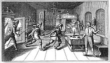
On the rock to the north-west lies Cheb castle, built in the 12th century and now mostly in ruins. The main attractions are the Chapel of Saints Erhard and Ursula, the Black Tower and the ruins of a palace; all from around 1180. The chapel has two storeys; the lower storey is in Romanesque style, while the upper storey is Gothic. An eight-cornered opening connects the two storeys. The upper-storey contains a ribbed vault supported on four polygonal columns with statues depicting sins, including a statue of a prostitute and Onan. In the banquet room of this castle, Wallenstein's officers Terzky, Kinsky, Illo and Neumann were assassinated on 25 February 1634. Wallenstein himself was murdered few hours later by Captain Devereux in the burgomaster's house at the main square. The house, a 15th-century gothic town hall (Pachelbel House), was transformed in 1872, it contains many historical relics and antiquities of the town of Cheb.

On the Market Place dating from the 13th century are a group of houses originating from the late-Gothic period known as Špalíček. This distinctive feature of the market place is a bizarre complex of eleven houses. The outline of the two blocks can still be seen on the oldest existing records of 1472.
The Green House on the market place belonged to the well-known Wrendl dynasty, whose family crest lies above the entrance. Johann Wolfgang von Goethe frequently spent time here.

The Church of St. Nicholas was established in the 13th century as a three-naved basilica, of which the western portal and the lower part of the tower remain in place. The three-part nave, presbytery and sacristy stem from the Gothic era. After the fire of 1742, the tower was rebuilt with a baroque cupola, after the design of the indigenous architect Balthasar Neumann. The top of the twin steeples were destroyed by German artillery fire during World War II and restored in summer 2008.
The Franciscan Church is located in the town centre. The Church of St. Clara was built between 1708 and 1711 according to a design of Christoph Dientzenhofer.
The early-baroque Pilgrimage area Maria Loreto is located in a local part of Starý Hrozňatov. The annex, which had lain in ruins since 1990 has since been renovated through the initiative of an inhabitant of the neighbouring town Waldsassen.

In popular culture[]
In Arthur Conan Doyle's Sherlock Holmes story "A Scandal in Bohemia", it is referred to by Holmes as 'Egria'.
Notable people[]
- Johannes Widmann (c. 1460 – after 1498), German mathematician
- Johann Habermann (1516–1590), German Lutheran theologian
- Albrecht von Wallenstein (1583–1634), military leader and statesman
- Johann Georg Macasius (1617–1653), German physician
- Pavel Klein (1652–1717), Jesuit missionary, botanist, writer
- Johann Balthasar Neumann (1687–1753), German architect and military artillery engineer
- Hugo Zuckermann (1881–1914), Jewish-Austrian poet
- Rudolf Serkin (1903–1991), Czech-American pianist
- Erich Riedl (1933–2018), German politician
- Peter Glotz (1939–2005), German politician and social scientist
- Norbert Singer (born 1939), German automotive engineer
- Pavel Nedvěd (born 1972), footballer, 2004 Ballon d'Or winner
Twin towns – sister cities[]
 Bắc Ninh, Vietnam
 Hof, Germany
 Nizhny Tagil, Russia
Since the fall of the Iron Curtain, Cheb has also had cordial relationships with the neighbouring German towns of Waldsassen and Marktredwitz.
Gallery[]

Church of St. Nicolas

Church of St. Nicolas and Elisabeth – reconstruction in 2008 with new tops of the towers (copies like 1869)

Sand gate near the Ohře river
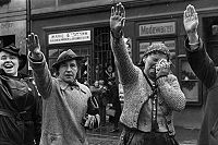
People of Eger greeting German soldiers with the Hitler salute in October 1938


References[]
- ^ "Population of Municipalities – 1 January 2021". Czech Statistical Office. 2021-04-30.
- ^ "O původu názvů západočeských měst I" (in Czech). Český rozhlas Plzeň. Retrieved 2020-11-23.
- ^ "Slavic Hill Fort and Castle in Cheb". cestovani.kr-karlovarsky.cz.
- ^ "Welcome to the 97th Infantry Division". www.97thdivision.com.
- ^ "Město Cheb". 29 June 2012. Archived from the original on 29 June 2012.
- ^ Ernst Pfohl: Ortslexikon Sudetenland. Seite 124. Helmut Preußler Verlag-Nürnberg.1987. ISBN 3-925362-47-9
- ^ "Historický lexikon obcí České republiky 1869–2011 – Okres Cheb" (in Czech). Czech Statistical Office. 2015-12-21. pp. 3–4.
- ^ "Cheb Climate Normals 1961–1990". National Oceanic and Atmospheric Administration. Retrieved 29 March 2015.
- ^ Miller, Marjorie. "Ethnic Discord: Back to Sudetenland? : The pressure is building on Czechs to return homes and property they seized from Germans after World War II or to at least compensate the victims." Los Angeles Times. July 19, 1994. p. 2. Retrieved on 15 June 2016.
- ^ "Chebské letiště je nejstarší v České republice" (in Czech). Chebský deník. 2007-05-12. Retrieved 2020-11-23.
- ^ "Partnerská města: Cheb" (in Czech). Město Cheb. Retrieved 2019-08-22.
Further reading[]
- Chisholm, Hugh, ed. (1911). . Encyclopædia Britannica (11th ed.). Cambridge University Press.
External links[]
| Wikimedia Commons has media related to Cheb. |
| Wikivoyage has a travel guide for Cheb. |
- Official website
- Cheb Castle site
- Church of Maria Loreto (in German)
- Hardeck Castle (in German)
- Euregio Egrensis (in German)
| show Authority control |
|---|
- Populated places in Cheb District
- Cheb
- Cities and towns in the Czech Republic