Cheffois
Cheffois | |
|---|---|
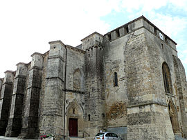 The church of Saint-Pierre, in Cheffois | |
show Location of Cheffois | |
 Cheffois | |
| Coordinates: 46°40′10″N 0°47′24″W / 46.6694°N 0.79°WCoordinates: 46°40′10″N 0°47′24″W / 46.6694°N 0.79°W | |
| Country | France |
| Region | Pays de la Loire |
| Department | Vendée |
| Arrondissement | Fontenay-le-Comte |
| Canton | La Châtaigneraie |
| Intercommunality | Pays de la Châtaigneraie |
| Government | |
| • Mayor (2020–2026) | Jean-Marie Giraud |
| Area 1 | 18.63 km2 (7.19 sq mi) |
| Population (Jan. 2018)[1] | 985 |
| • Density | 53/km2 (140/sq mi) |
| Time zone | UTC+01:00 (CET) |
| • Summer (DST) | UTC+02:00 (CEST) |
| INSEE/Postal code | 85067 /85390 |
| Elevation | 75–199 m (246–653 ft) |
| 1 French Land Register data, which excludes lakes, ponds, glaciers > 1 km2 (0.386 sq mi or 247 acres) and river estuaries. | |


Cheffois (French pronunciation: [ʃɛfwa]) is a commune of the Vendée department in the Pays de la Loire region in western France.
See also[]
References[]
- ^ "Populations légales 2018". INSEE. 28 December 2020.
| Wikimedia Commons has media related to Cheffois. |
This Vendée geographical article is a stub. You can help Wikipedia by . |
Categories:
- Communes of Vendée
- Vendée geography stubs