Le Girouard
Le Girouard | |
|---|---|
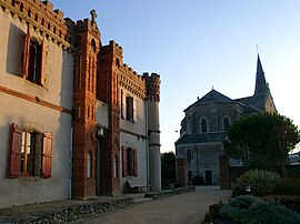 The church and the Château Gaillard, in the village | |
show Location of Le Girouard | |
 Le Girouard | |
| Coordinates: 46°34′08″N 1°35′54″W / 46.5689°N 1.5983°WCoordinates: 46°34′08″N 1°35′54″W / 46.5689°N 1.5983°W | |
| Country | France |
| Region | Pays de la Loire |
| Department | Vendée |
| Arrondissement | Les Sables-d'Olonne |
| Canton | Talmont-Saint-Hilaire |
| Intercommunality | Pays des Achards |
| Government | |
| • Mayor (2008–2014) | Auguste Grit |
| Area 1 | 25.10 km2 (9.69 sq mi) |
| Population (Jan. 2018)[1] | 1,073 |
| • Density | 43/km2 (110/sq mi) |
| Time zone | UTC+01:00 (CET) |
| • Summer (DST) | UTC+02:00 (CEST) |
| INSEE/Postal code | 85099 /85150 |
| Elevation | 14–72 m (46–236 ft) |
| 1 French Land Register data, which excludes lakes, ponds, glaciers > 1 km2 (0.386 sq mi or 247 acres) and river estuaries. | |


Le Girouard is a commune in the Vendée department in the Pays de la Loire region in western France.
Demography[]
| Year | 1968 | 1975 | 1982 | 1990 | 1999 | 2007 | 2012 | 2017 |
|---|---|---|---|---|---|---|---|---|
| Population | 749 | 616 | 489 | 466 | 533 | 761 | 951 | 1050 |
See also[]
References[]
- ^ "Populations légales 2018". INSEE. 28 December 2020.
- ^ Population en historique depuis 1968, INSEE
| Wikimedia Commons has media related to Le Girouard. |
This Vendée geographical article is a stub. You can help Wikipedia by . |
Categories:
- Communes of Vendée
- Vendée geography stubs